Puketutu Island
| Puketutu Island | |
|---|---|
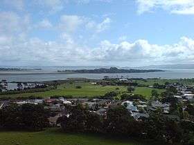 The island today, from Mangere Mountain | |
| Highest point | |
| Elevation | 65 m (213 ft) |
| Coordinates | 36°57′55″S 174°44′50″E / 36.965186°S 174.747248°ECoordinates: 36°57′55″S 174°44′50″E / 36.965186°S 174.747248°E |
| Geography | |
| Location | North Island, New Zealand |
| Geology | |
| Volcanic arc/belt | Auckland volcanic field |
Puketutu Island is a volcanic island in the Manukau Harbour, New Zealand, and is part of the Auckland volcanic field. European settlers called it Weekes' Island, but this was eventually abandoned in favour of the historical Māori name.
In the 1950s, several of its scoria cones were heavily quarried for fill to extend Auckland Airport nearby. The island's highest point, 65 m high Pinnacle Hill, was retained. The charitable trust now owning the forested island has proposed a scheme whereby biosolids from the nearby Mangere wastewater treatment plant (which surrounds the island, covering 600 ha on the landward sides, and served around 600,000 people in the 1990s)[1] could be used to reshape the older form of the island. While the process could take up to 35 years, the final goal is envisaged as becoming a park for the Auckland Region. [2]
The island was also used as the site for several pā (Māori earth fortifications usually guarding a settlement or important site) throughout the last centuries, though these were deserted by the time of the arrival of European colonists in the area.[3]
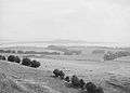 Puketutu Island (then called 'Weekes' Island') in the 1910s, before it lost most of its cones to quarrying.
 Puketutu Island's Pinnacle Hill, with a waka or canoe in the foreground.
See also
References
- City of Volcanoes: A geology of Auckland - Searle, Ernest J.; revised by Mayhill, R.D.; Longman Paul, 1981. First published 1964. ISBN 0-582-71784-1.
- ↑ Engineering to 1990 - IPENZ, Engineering Publications Co Ltd, Page 9
- ↑ Redemption near for Puketutu - City of Fire, insert magazine in the The New Zealand Herald, Friday 15 February 2008
- ↑ Ancient history (from the Sir Henry J Kelliher Charitable Trust website. Accessed 2008-06-21.)
External links
- Photographs of Puketutu Island held in Auckland Libraries' heritage collections.