Quabbin Reservoir
| Quabbin Reservoir | |
|---|---|
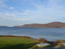 November 2005 | |
| Location | Massachusetts |
| Coordinates | 42°21′33″N 72°18′00″W / 42.35917°N 72.30000°WCoordinates: 42°21′33″N 72°18′00″W / 42.35917°N 72.30000°W |
| Lake type | Reservoir |
| Primary inflows | New Hampshire |
| Primary outflows | Atlantic ocean |
| Basin countries | United States |
| Max. length | 18 miles (28.9 km) |
| Surface area | 38.6 mi² (99.97 km²) |
| Average depth | 51 ft (16 m) |
| Max. depth | 150 ft (46 m) |
| Water volume | 412,000,000,000 US gal (1.56 km3) |
| Shore length1 | 181 mi (291 km) |
| Surface elevation | 522 ft (159 m) |
| Settlements | Belchertown Petersham Hardwick Ware New Salem Shutesbury |
| 1 Shore length is not a well-defined measure. | |
The Quabbin Reservoir is the largest inland body of water in the Commonwealth of Massachusetts and was built between 1930 and 1939. Today along with the Wachusett Reservoir, it is the primary water supply for Boston, some 65 miles (105 km) to the east, as well as 40 other communities in Greater Boston. It also supplies water to three towns west of the reservoir and acts as backup supply for three others.[1] It has an aggregate capacity of 412 billion US gallons (1,560 GL) and an area of 38.6 square miles (99.9 km²).
Structures and water flow
Quabbin Reservoir water flows to the Wachusett Reservoir using the Quabbin Aqueduct. The Quabbin watershed is managed by the Massachusetts Department of Conservation and Recreation, while the water supply system is operated by the Massachusetts Water Resources Authority. The Winsor Dam and the Goodnough Dike form the reservoir from impoundments of the three branches of the Swift River. The Quabbin Reservoir is part of the Chicopee River Watershed, which in turn feeds the Connecticut River.
The Quabbin Spillway (which follows part of Quabbin Hill Road in Belchertown), allows water to bypass the Winsor Dam and join the Swift River when the reservoir is full.
In 1947, the Massachusetts Legislature authorized the construction of the Chicopee Valley Aqueduct to deliver Quabbin water to three communities in Western Massachusetts: Chicopee, South Hadley, and Wilbraham. In 1951, with the Quabbin-Wachusett system sufficient to meet foreseeable needs, the Cochituate Aqueduct was abandoned, and the Framingham Reservoir system was placed on emergency stand-by. The present Lake Cochituate is the so-called Framingham Reservoir and now serves as a major swimming and boating resource but is no longer part of the potable water supply.
History
Demand for water exceeds local supplies
Metropolitan Boston's demands for fresh water began to outstrip its local supplies in the early part of the nineteenth century. Many possible sources of water were explored, including groundwater and rivers, but none were considered adequate in quantity and cleanliness to meet the needs of the rapidly growing city. After several years of controversy, the Massachusetts General Court (the official name of the state legislature) authorized the construction of the Cochituate Aqueduct to bring water to Boston from Lake Cochituate in Wayland and Natick.
This established three important policies, which remain in force today:
- Public, rather than private, ownership of the public water supply system.
- Use of upland reservoirs, with gravity-fed rather than pumped supply systems.
- Watershed protection, rather than filtration, as the primary mechanism of ensuring wholesome supplies.
By 1875, with demand again on the verge of exceeding supply, the Boston Water Board was established to take over the operations of the Cochituate Water Board, construct five new reservoirs on the Sudbury River in Framingham, Massachusetts, and a new Sudbury Aqueduct to deliver that water to the city.
Recommendation for establishment and related construction
In 1895, the Massachusetts Board of Health issued a report analyzing population and water-use trends, and recommended the creation of a Metropolitan Water District, serving several suburban communities in addition to Boston, and the construction of two new reservoirs: one on the Nashua River northeast of Worcester, and one in the Swift River Valley.
The General Court acted to establish the Metropolitan Water District, including 26 communities within ten miles (16 km) of the Massachusetts State House, later in 1895. The Wachusett Reservoir was completed in 1908. The Board of Health study had anticipated that Swift River water would be required by 1915, but this prediction had proven overly pessimistic. The introduction of mandatory water metering in Water District communities, and other efforts to reduce waste and inefficient uses, made it possible to delay construction of new water sources until the 1930s.
Frank E. Winsor was chief engineer for the Metropolitan Water District from 1926 until his death in 1939. He was closely involved in the design and construction of Winsor Dam, Goodnough Dike and the Quabbin Reservoir. Winsor Dam is named for him.[2] He had previously been chief engineer for the building of the Scituate Reservoir in Rhode Island.
A 1922 study officially endorsed the Swift River Valley as the next extension of the water system and created the Metropolitan District Commission (MDC), now the Massachusetts Water Resource Authority (MWRA), to oversee the construction and maintain the system after its completion. In 1926, construction began on the first stage of the project, a tunnel connecting Wachusett Reservoir with the Ware River. This is called the Ware River Diversion. During the 1930s, this tunnel was extended to the Swift River. The complete tunnel is now known as the Quabbin Aqueduct.
Opposition
Although the project was enthusiastically supported by lawmakers in the Boston area, it was opposed by residents of the affected towns. The state of Connecticut sued Massachusetts, claiming waters that were rightfully meant to flow into the Connecticut River, and subsequently through their state, were being illegally diverted. The lawsuit was unsuccessful, but Massachusetts was still bound by discharge minimums set under the regulatory authority of the Secretary of War over navigable waters.[3]
Reservoir formed
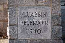
Before the reservoir’s construction, there was a hill in Enfield called Quabbin Hill and a lake in Greenwich called Quabbin Lake. Named for a Native American chief called Nani-Quaben, meaning place of many waters, these became the basis for naming the new reservoir. The Quabbin was formed by inundating the Swift River Valley, a drainage basin lying entirely within the state, by damming the river and a col, through which Beaver Brook would have otherwise provided another outlet for its water. When construction began in 1936, the Swift River was redirected from its riverbed through a diversion tunnel. On August 14, 1939, that tunnel was sealed with rock. Over the next seven years, the waters of the Quabbin Reservoir slowly rose behind the newly completed Winsor Dam, an earth-filled structure 2,640 feet (800 m) long, rising 170 feet (52 m) above the riverbed, and the slightly smaller Goodnough Dike. The water gradually submerged the roads that had linked the towns. It swallowed all but the peaks of about sixty hills and mountains, transforming Prescott Ridge into Prescott Peninsula. They ended the forming of the Quabbin Reservoir around the 1940s.
During the time in which the reservoir was forming, the eventual bed of the reservoir was used as the Quabbin Reservoir Precision Bombing and Gunnery Range. The range was used by planes from both Hanscom Army Air Field and Westover Army Air Field.
Towns disincorporated
The Quabbin's creation required the flooding, and thus the disincorporation, in April 1938, of four towns: Dana (located in Worcester County), Enfield, Greenwich, and Prescott (all located in Hampshire County). The land remaining from the disincorporated towns was added to surrounding municipalities, including Belchertown, Pelham, New Salem, Petersham, Hardwick and Ware. One additional town on the reservoir is Shutesbury, in Franklin County. Because of New Salem's annexation of the Prescott Peninsula, a large wedge of land shifted from Hampshire County to Franklin County. Today, the majority of the reservoir lies in either New Salem or Petersham.
In addition, thirty-six miles of the Boston and Albany Railroad's Athol Branch were abandoned (originally the Springfield, Athol and Northeastern Railroad). Route 21, formerly reaching Athol, was truncated to the south side of the reservoir, and new roads—now US 202 and Route 32A—were built, respectively, on the western and eastern side of the reservoir.
When the buildings in the towns flooded by the reservoir were destroyed, the cellars were left intact. Old roads that once led to the flooded towns can be followed to the water's edge. Not all elements of the towns were flooded, however. Town memorials and cemeteries in the four towns were moved to Quabbin Park Cemetery, located on Route 9 in Ware, just off the Quabbin's lands. Many other public buildings were moved to other locations. For example, the Prescott First Congregational Church was moved to South Hadley.[4]
Three student housing facilities at Hampshire College in Amherst are named after the discontinued towns of Greenwich, Prescott, and Enfield. In addition, Hampshire College named another facility on its campus Dana House, after the other discontinued town of Dana.
Four residence halls at the nearby Eagle Hill School are also named for the four towns - Greenwich, Prescott, Dana and Enfield.
Watershed land use and recreation
Because of state restrictions, most areas around the reservoir are accessible only by foot, through fifty-five surrounding gates. Few people ever go into the deep woods, and it has become a wildlife area. Bald eagles, moose, deer, coyotes, black bears, foxes, and bobcats share the habitat, among others. Large portions of Dana are on higher ground, and its remains, predominantly cellar holes, as well as the former town green (where a historic stone marker was placed) can be visited.
Much of Prescott is also above water, on what is now known as the Prescott Peninsula, but it cannot be visited because of state restrictions, although there is an annual tour of the town conducted by the Swift River Valley Historical Society. A few houses and roads exist which were once part of North Prescott (now New Salem), and there is a town line marker just north of the gates, indicating the former town line for Prescott. Cellar holes have been filled near the center of what was once Prescott to accommodate the former Five College Radio Astronomy Observatory, once operated by the University of Massachusetts Amherst.
On August 23, 2016, a small airplane made an emergency landing on a sandbar in the reservoir.[5]
Commercial timber extraction
While Prescott Peninsula is off limits for hikers and visitors, the state has authorized commercial timber harvesting on the Prescott Peninsula and other portions of the Quabbin Forest.[6]
The state placed a moratorium on commercial logging at the Quabbin while it studied controversial clearcuts. The moratorium has been lifted and commercial logging resumed in 2014.[7]
Fishing
Fishing is allowed in designated areas in the northern portions of the reservoir. There is a visitor center south of the reservoir, as well as an observation tower, and Enfield Lookout. This area is accessible by car from the south using State Route 9. The reservation is a popular spot for hiking and other outdoor activities. This area was formerly part of the town of Enfield, which was annexed by Belchertown.
Popular culture
- H.P. Lovecraft's stories "The Dunwich Horror" and "The Color Out of Space" are set in the valley before it was flooded for the reservoir.[8]
- Both the film Dreamcatcher and the Stephen King novel upon which it was based have scenes set at the Quabbin Reservoir.
See also
Notes
- ↑ MWRA Online
- ↑ Water for Greater Boston
- ↑ U.S. Supreme Court, Connecticut v. Massachusetts, 282 U.S. 660 (1931)
- ↑ The Collection | Mount Holyoke College
- ↑ Rosen, Andy (August 24, 2016). "No known environmental threats after Quabbin plane landing". The Boston Globe. Retrieved August 24, 2016.
- ↑
- ↑
- ↑ Charles P. Mitchell, The Complete H.P. Lovecraft Filmography p.9 (2001).
Further reading
- Conuel, Thomas. Quabbin: The Accidental Wilderness. Amherst, Massachusetts: University of Massachusetts Press, 1990.
- Tougias, Michael. Quabbin: A History and Explorer's Guide. Yarmouth Port, Massachusetts: On Cape Publications, 2002. OCLC 50812740.
- Under Quabbin: The Search for the Lost Towns, A WGBY Production. 2001. Ed Kelkowski, UMASS Amherst Biology professor, Massachusetts State Police. DVD 974.423
- J. R. Greene. "The Creation of Quabbin Reservoir; The Death of the Swift River Valley." The Transcript Press, 32 Freedom Street, Athol, MA 01331, 1978. ISBN 0-9609404-0-5
External links
- Quabbin Reservoir Levels
- Massachusetts Department of Conservation and Recreation, Quabbin Reservoir
- Court order and statement of facts about MWRA facilities, addresses conditions far from Quabbin source 1999-5-13
History
- Map showing the towns buried under Quabbin as they looked in 1903 with original house locations and current reservoir water level
- Interactive Map Interactive version of the 1903 map above (showing the towns buried under Quabbin as they looked in 1903 with original house locations and current reservoir water level)
- The Quabbin, a WBUR documentary about the creation of the Quabbin Reservoir and the people who were displaced.
- Massachusetts Water Resources Authority, Water System History
- A History of the Development of the Metropolitan District Commission Water Supply System
- Technical Information on Winsor Dam
- History of providing water for Greater Boston
- The Swift River Valley Historical Society
| |||||||||||||||||||||||||
| |||||||||||||||||||||||||
| |||||||||||||||||||||||||
| |||||||||||||||||||||||||
| |||||||||||||||||||||||||
| |||||||||||||||||||||||||
| |||||||||||||||||||||||||