Quebrada Limón
| Barrio Quebrada Limón | |
|---|---|
|
Scene in Barrio Quebrada Limon at PR-502 near Km 2.0 | |
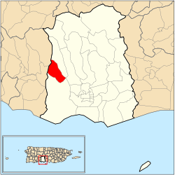 Location of barrio Quebrada Limón within the municipality of Ponce shown in red | |
| Country |
|
| Territory |
|
| Municipality |
|
| Area | |
| • Total | 2.67 sq mi (6.9 km2) |
| • Land | 2.67 sq mi (6.9 km2) |
| • Water | 0.00 sq mi (0.0 km2) |
| Population (2000) | |
| • Total | 804 |
| • Density | 301/sq mi (116/km2) |
| Source: 2000 Census | |
%2C_Ponce%2C_PR_(DSC02305A).jpg)
Quebrada Limón is one of the 31 barrios of the municipality of Ponce, Puerto Rico. Along with Anón, Coto Laurel, Guaraguao, Marueño, Real, and San Patricio, and the coastal barrios of Canas and Capitanejo, Quebrada Limón is one of the municipality's nine bordering barrios. It borders the municipality of Peñuelas. It was founded in 1878.[1]
Location
Quebrada Limón is a rural barrio located in the western section of the municipality, northwest of the center of the city at Plaza Las Delicias, and at latitude 18.054552 N, and longitude -66.671163 W.[2] The toponomy, or origin of the name, alludes to the narrow path between mountains oftentimes producing a stream or creek that runs down a glen.[3]
Boundaries
Quebrada Limón is bounded on the North by the hills south of El Pecho Road and the hills north of Marungueyes Road, on the South by the hills north of Bello Road, and Clavel Street, on the West by hills east of PR-520, and on the East by the hills west of PR-502.[4][5]
In terms of barrio-to-barrio boundaries, Quebrada Limón is bounded in the North by Marueño, in the South by Canas, in the West by barrios Tallaboa Alta and Rucio of the municipality of Peñuelas, and in the East by Marueño and Canas.
Features and demographics
Quebrada Limón is home to the communities of Pastillo Canas and Hacienda Josefa. Pastillo Canas is located in the southern section of the barrio, near barrio Canas' Pastillo community. The rest of Quebrada Limón is strictly rural.
Quebrada Limón has 2.67 square miles (6.9 km2) of land area and no water area.[6] In 2000, the population of Quebrada Limón was 804 persons, and it had a density of 301 persons per square mile.[6]
The main road serving barrio Quebrada Limon is PR-502.[7]
The highest point in barrio Quebrada Limón stands at 984 feet over sea level and is located at the extreme northern end of the barrio.[8]
Notable Landmarks
Several streams make their way through this rural barrio, including the brook from which the barrio draws its name: Quebrada Limón (English: Limón Brook). A section of Rio Pastillo also winds its way through the barrio. In fact, Limon Brook feeds into Río Pastillo. [4]
Coordinates: 18°03′20″N 66°40′20″W / 18.0554408°N 66.6721340°W[9]
References
- ↑ Barrios de Ponce. Antepasados Esclavos.(From: Pedro Tomás de Córdoba. Memorias geográficas, históricas, económicas y estadísticas de la Isla de Puerto Rico.) Retrieved 28 November 2014.
- ↑ City Melt Retrieved March 3, 2010.
- ↑ Government of the Municipality of Ponce. Periodico "El Señorial". Special issue: Carnaval Ponceño 2013. February 2013. Page 17. Ponce, Puerto Rico.
- 1 2 General Purpose Population Data, Census 2000. Unidad de Sistemas de Información Geográfica, Área de Tecnología de Información Gubernamental, Oficina de Gerencia y Presupuesto. Gobierno de Puerto Rico. Archived August 12, 2010, at the Wayback Machine. Retrieved March 3, 2010.
- ↑ Ponce Topographic Map. Map Styles: Map and Shaded. Trails.com. From: United States Geological Survey. Topo Map. Projection: NAD83/WGS84. Retrieved March 3, 2010.
- 1 2 Ponce Municipio, Puerto Rico -- County Subdivision and Place: GCT-PH1. Population, Housing Units, Area, and Density: 2000 (Data Set: Census 2000 Summary File 1 (SF 1) 100-Percent Data) Archived January 31, 2009, at the Wayback Machine. Retrieved March 3, 2010.
- ↑ General Purpose Population Data, Census 2000. Unidad de Sistemas de Información Geográfica, Área de Tecnología de Información Gubernamental, Oficina de Gerencia y Presupuesto. Gobierno de Puerto Rico. Archived August 12, 2010, at the Wayback Machine. Retrieved February 22, 2010.
- ↑ Maptest. Archived February 18, 2010, at the Wayback Machine. Government of the Commonwealth of Puerto Rico. General Purpose Population Data, Census 2000. Unidad de Sistemas de Información Geográfica, Área de Tecnología de Información Gubernamental, Oficina de Gerencia y Presupuesto. Gobierno de Puerto Rico. Retrieved 14 November 2011.
- ↑ U.S. Geological Survey Geographic Names Information System: Quebrada Limón Barrio