Querqueville
| Querqueville | ||
|---|---|---|
|
View of the cemetery | ||
| ||
 Querqueville | ||
|
Location within Normandy region  Querqueville | ||
| Coordinates: 49°39′51″N 1°41′38″W / 49.6642°N 1.6939°WCoordinates: 49°39′51″N 1°41′38″W / 49.6642°N 1.6939°W | ||
| Country | France | |
| Region | Normandy | |
| Department | Manche | |
| Arrondissement | Cherbourg | |
| Canton | La Hague | |
| Government | ||
| • Mayor (2008–2014) | Jean-Michel Maggle | |
| Area1 | 5.56 km2 (2.15 sq mi) | |
| Population (2006)2 | 5,536 | |
| • Density | 1,000/km2 (2,600/sq mi) | |
| Time zone | CET (UTC+1) | |
| • Summer (DST) | CEST (UTC+2) | |
| INSEE/Postal code | 50416 / 50460 | |
| Elevation |
0–115 m (0–377 ft) (avg. 50 m or 160 ft) | |
| Website | www.ville-querqueville.fr | |
|
1 French Land Register data, which excludes lakes, ponds, glaciers > 1 km² (0.386 sq mi or 247 acres) and river estuaries. 2 Population without double counting: residents of multiple communes (e.g., students and military personnel) only counted once. | ||
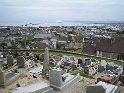
View of Querqueville from the cemetery
Querqueville is a former commune in the Manche department in north-western France. On 1 January 2016, it was merged into the new commune of Cherbourg-en-Cotentin.[1]
The Chapel of Saint Germanus (Chapelle Saint-Germain) with its trefoil floorplan incorporates elements of one of the earliest surviving places of Christian worship in the Cotentin Peninsula - perhaps second only to the Gallo-Roman baptistry at Port-Bail.
Heraldry
.svg.png) |
The arms of Querqueville are blazoned: Gules, a trefoil chapel Or, pierced and open sable, on a chief azure, three bees Or. |
See also
References
- ↑ Arrêté préfectoral 1 December 2015 (French)
| Wikimedia Commons has media related to Querqueville. |
This article is issued from Wikipedia - version of the 9/1/2016. The text is available under the Creative Commons Attribution/Share Alike but additional terms may apply for the media files.