Quillota
| Quillota | |||||
|---|---|---|---|---|---|
| City and Commune | |||||
 | |||||
|
Motto: City created with care (Ciudad creada con cariño) | |||||
| Coordinates: 32°52′S 71°15′W / 32.867°S 71.250°WCoordinates: 32°52′S 71°15′W / 32.867°S 71.250°W | |||||
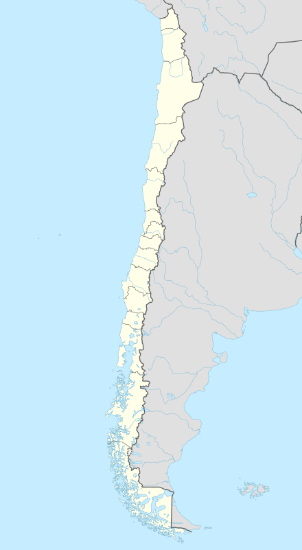
| Country | Chile | ||||
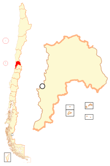
| Region | Valparaíso | ||||
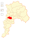
| Province | Quillota | ||||
| Founded | November 11, 1717 | ||||
| Government[1] | |||||
| • Type | Municipality | ||||
| • Alcalde | Luis Alberto Mella Gajardo (DC) | ||||
| Area[2] | |||||
| • Total | 302 km2 (117 sq mi) | ||||
| Elevation | 462 m (1,516 ft) | ||||
| Population (2012 Census)[2] | |||||
| • Total | 85,262 | ||||
| • Density | 280/km2 (730/sq mi) | ||||
| • Urban | 66,025 | ||||
| • Rural | 9,891 | ||||
| Demonym(s) | Quillotan | ||||
| Sex[2] | |||||
| • Men | 37,191 | ||||
| • Women | 38,725 | ||||
| Time zone | CLT [3] (UTC-4) | ||||
| • Summer (DST) | CLST [4] (UTC-3) | ||||
| Postal code | 2430000 | ||||
| Area code(s) | 56 + 33 | ||||
| Climate | Csb | ||||
| Website | Official website (Spanish) | ||||
Quillota is a city located in the Aconcagua River valley of central Chile's Valparaíso Region. It is the capital and largest city of the Quillota Province where many inhabitants live in the surrounding farm areas of San Isidro, La Palma, Pocochay, and San Pedro. It is an important agricultural center, mainly because the plantations of avocado and cherimoya (custard apple) trees.
Quillota is connected with the city of La Calera by the small town of La Cruz. The area's agriculture and landscape was described by Charles Darwin in his book The Voyage of the Beagle. Nearby La Campana National Park holds a plaque at a viewpoint Darwin once visited.
Quillota is 120 kilometres (75 mi) from the national capital Santiago and 60 km (37 mi) from the regional capital Valparaíso.
History
The Quillota valley has been densely populated for about 2,000 years. At the outset, the area was inhabited by Native Americans of the Bato and Lleo-Lleo cultures, who had migrated to the valley because of the fertile land south of the Aconcagua River. These natives where later influenced by Mapuches and Diaguitas. The Diaguitas are credited with the evolution of the local culture of the Aconcagua zone and were well known for their pottery.
Later, Quillota was mitimae and the capital of Qullasuyu, the southern Inca Empire.
Diego de Almagro arrived in the valley in 1536. Incan scouts directed him to a beautiful and very fertile valley where the "Quillotas" lived. (Even before Almagro's arrival, a Spanish soldier from Peru called Don Gonzalo Calvo de Barrientos had been captured by the Quillotas and lived in the valley, learning the local language and culture during his captivity.)
Almagro was delighted with the valley, but as he was searching for gold and found none he returned to Peru. Almagro crossed the valley of Quillota and its environs. And having found the Aconcagua river overflowed and with few possibilities of finding gold, he deemed the land too difficult and returned to Peru, where he was executed.
Later, in 1540, Pedro de Valdivia arrived in Chile with the title of Governor of Chile. He arrived in the valley and built farms and houses, mainly for the slaves and the Indians who were working for him. Almost the whole area occupied by present-day Quillota was Valdivia's property.
De Valdivia established here his fortress between San Pedro and Limache, extracting gold from La Campana mountain and cultivating the Rautén valley, La Palma, Boco and take for himself all the area as his personal property, leaving the Mapocho valley as capital when he founded Santiago.
After the conquest and during the Colonial period,[5] population was increasing with the mix of races (Spaniards and Aconcaguas) and culture.
Until 1585, Quillota was declared a corregimiento, and it was the main place of a large province between Illapel and Casablanca.
In the 16th century were some tries to founding in the Quillota valley a village with all features and requirements ordered by Spanish kingdom, but it did not succeed.
It was only on November 11, 1717, St. Martin's Day, that Quillota was founded as a city, originally named "Village of San Martin de la Concha of Quillota" in the valley bordering Mayaca Hill. The city was founded by the bishop, Luis Romero, and the governor, Don José de Santiago Concha y Salvatierra.
Demographics
According to data from the 2002 Census of Population and Housing, Quillota had 75,916 inhabitants; of these, 66,025 (87.0%) lived in urban areas and 9,891 (13.0%) in rural areas. At that time, there were 37,191 men and 38,725 women.[2]
A large part of Quillota's population is descendants of Spanish settlers and Mestizos. There are still a few families with lands in the valley given by the Spanish governors.
City planning
Quillota's motto is "Ciudad creada con cariño" meaning "City created with care". Quillota remains one of the most traditional cities in Chile in that its layout still mainly corresponds to the original colonial Spanish layout of seven blocks square. Due to the geological composition of the ground and the frequency of earthquakes, its architecture has remained low-rise (with a four-story maximum) and traditional. Today, the commune spans an area of 302 km2 (117 sq mi).[2]
Given its fertile soil, its commune's economy is mainly agricultural, and it is one of the main produce centers in the country.
Administration

As a commune, Quillota is a third-level administrative division of Chile administered by a municipal council, headed by an alcalde who is directly elected every four years. The 2008-2012 alcalde is Luis Alberto Mella Gajardo (DC). The municipal council has the following members:[1]
- Mauricio Javier Ávila Pino (DC)
- María Genoveva Baeza Hermosilla (RN)
- Fernando Alberto Puentes Wasaff (DC)
- José Antonio Rebolar Rivas (RN)
- Víctor Manuel Vergara Flores (PR)
- Alejandro Eduardo Villarroel Castillo (UDI)
Within the electoral divisions of Chile, Quillota is represented in the Chamber of Deputies by Mr. Eduardo Cerda (PDC) and Mrs. Andrea Molina (UDI) as part of the 10th electoral district, (together with La Ligua, Petorca, Cabildo, Papudo, Zapallar, Puchuncaví, Quintero, Nogales, Calera, La Cruz and Hijuelas). The commune is represented in the Senate by Ignacio Walker Prieto (PDC) and Lily Pérez San Martín (RN) as part of the 5th senatorial constituency (Valparaíso-Cordillera).
Schools and Universities
The city is well endowed with educational facilities, for primary and secondary education. Given its agricultural importance in the country, many universities of the region have established their agricultural studies faculties here. The following is a list of some of these facilities:
- Colegio Valle del Aconcagua
- Colegio Inglés Saint Gabriel
- Colegio Francisco de Miranda
- Colegio Nuestra Señora del Huerto
- Colegio San Ignacio de LaSalle
- Colegio Quillota Terranova
- Colegio Nueva Era Siglo XXI
- Colegio Técnico Diego Echeverría Castro, Marist Brothers
- Instituto Rafael Ariztía, Marist Brothers
- Liceo Comercial de Quillota
- Liceo de Hombres Santiago Escutti Orrego
- School of Agricultural Studies of the Universidad Católica de Valparaíso.
Tourism
Within the tourism sector we find places of entertainment open to the general public, such as: 4
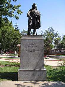
- Quillota Square: For some, one of the most beautiful in the country, is inserted into the heart of the Commune itself. A Parish found around San Martin de Tours, the Santo Domingo Convent, the Provincial Government, the Municipality of Quillota, etc. Completely renovated in late 2008, has a large cypress fallen in storms that hit the area in the 1980s, which was cut by the community, as a witness. Is also the Odeon, donated to the city by the Italian community. It's a place where you can see the valley tree species themselves, like palm trees in the center of the city, along with sculptures representing the four seasons.
- Municipal Park "Aconcagua": Located in La Conception street, almost at the river Aconcagua. Recreation center with playground, barbecue grills, vast green spaces, etc..
- "The Boco": distant rural village a few kilometers from the city center. To access it you must cross the bridge vehicular / pedestrian is at the end of Calle La Concepcion, coming to this small town. In it you can find the "Quebrada del Pepper" where is Ecotourism Center "El Grillo" Aerodrome Quillota and Resort and Cabins "Eden", which has cabins and rooms for singles and doubles customers, with private pool, spa, gym, etc., and also a park open to the community, with a large pool and Restaurant. Nearly Boco can find Rauten sector, with plenty of trees and a beautiful dam to spend a day with the family.
- Historical and Archaeological Museum and Public Library Quillota Quillota Melvin Jones: The Historical-Archaeological Museum Quillota (MHAQ) was officially created on December 5, 1997, at the initiative of the Research and Dissemination Workshop of History and Geography Quillota to rescue the tradition Historical and Archaeological Heritage city. Currently works, along with the Public Library, in the Colonial House (MN), in San Martin Street # 336.
- 'Armored Cavalry Regiment "Grenadiers"': military compound, located in the San Isidro, in Quillota, once outside the Cavalry School. It has a museum of vintage cars and carriages, and also a museum of tanks. You can also enjoy the gardens and parks with ancient trees, as there are a large gum inside. It has beautiful structures, including the Chapel, built in 1892 and opened Quillota community in 1917, semi baroque style (indefinite), with sculptures and elements brought mainly from Cuzco (Ecuador), among other things.
- Botanical Garden "The Escalante": It is 1.8 km. of the City of "Boco". Created more than a decade, his specialty is Chilean cacti and other American countries, where the plants are found in the wild. There are over 1,000 species of cactus field, plus a collection of orchids Chilean habitat (15 species), and Chilean bulbs. There is also a sector of palms, native trees and shrubs, exotic trees and a walking trail around the site, including a creek with running water and native plants.
- School Rodeo "The Huaso": Located in rural La Palma, this school is located rodeo, in a beautiful environment in which native trees are highlighted, such as the Chilean Palm, araucaria pines, among others. It offers programs for adults and children for both men and ladies. Its purpose is to strengthen and grow our traditions promoveer huaso and mainly our national sport rodeo. It also has Criollos Games, activities related to the field and museum visits.
- Huaso House and Museum: Located in the downtown area of the municipality, on White Street. It presents the history of huaso in Chile and the Central Zone. You can visit on weekdays.
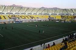
- Stadium Bicentennial Lucio Fariña Fernández: sports stadium remodeled 2010. Is Local soccer club headquarters, San Luis de Quillota. It has an estimated capacity of 7,500 spectators. Includes lighting on the roof structure, perimeter lighting, scoreboard, sound system, individual seats (seats) and a synthetic pitch of 105 x 68 meters as is provided for FIFA, able to be used 8 hours a day. Furthermore, it provides a stage for artistic events, with dressing room, newsroom management and includes two gyms, medical exam room and first aid room for alternative sports such as martial arts. Include the possibility of an archaeological exhibition hall, which is expected to expose future remains Aconcagua Cultural Complex, Bato and Inca, who were rescued during the process of building the enclosure.
- Horseback "Old Pigeon"': Make riding by the natural landscapes of the city, through majestic landscapes and pristine. It also offers hayrides and leases them for weddings and / or events.
- Center "Sport Club Q"': Event Center and Sports Complex, located at 8 Whereabouts way to the cross, to the side of Route 60 CH. Football has tennis, tennis, pools, Restaurant, Spa, Gym, sports schools and function rooms.
- On 28 March 2016, Cairns, Australia local amateur archaeologist and metal detectorist Scott MacLeod, found a wine bottle from Quillota Santiago Chile. The bottle was found in a bottle dump at a depth of 1 metre at the rear of Alf Martin's (Bill Smith's) 'Beehive Hotel', MacDonald Street Smithfield (S16. 86140, E 145.70061.(Circa 1876-1879). The earthenware bottle was stamped 'PREMIADO MEDALLA De La EXHIBICION De SANTIAGO 1872 A.UNGEMACH y Cia Quillota.
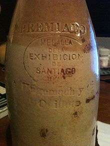 Quillota to Cairns Australia
Quilllota photos

References
- 1 2 "Municipality of Quillota" (in Spanish). Retrieved 29 July 2010.
- 1 2 3 4 5 "National Statistics Institute" (in Spanish). Retrieved 30 July 2010.
- ↑ "Chile Time". WorldTimeZones.org. Archived from the original on September 11, 2007. Retrieved 2010-07-29.
- ↑ "Chile Summer Time". WorldTimeZones.org. Archived from the original on September 11, 2007. Retrieved 2010-07-29.
- ↑ This is- Between the Spanish arrive to the valley and until the Chilean independence