Railway Village Historic District
|
Railway Village Historic District | |
 | |
  | |
| Location | Roughly along Adams St., from Mechanic and Church Sts., and Washington St., Milton, Massachusetts |
|---|---|
| Coordinates | 42°16′1″N 71°2′12″W / 42.26694°N 71.03667°WCoordinates: 42°16′1″N 71°2′12″W / 42.26694°N 71.03667°W |
| Area | 30 acres (12 ha) |
| Architect | Dirlam, Arland; et al. |
| Architectural style | Colonial, Greek Revival, et al. |
| NRHP Reference # | [1] |
| Added to NRHP | March 06, 2000 |
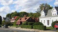
The Railway Village Historic District is a historic district encompassing a densely populated, predominantly residential, area of eastern Milton, Massachusetts. The 30-acre (12 ha) district lies roughly between East Milton Square and the town line with neighboring Quincy. The area's significant growth occurred after the 1826 construction of the Granite Railway, which transported stone from the nearby granite quarries to the Neponset River. This resulted in the movement to the area of stone workers and related interests. The principal thoroughfare of the district is Adams Street; the district extends along Pierce Street, Granite Place, and Washington Street, and includes properties on intervening and connecting streets.[2]
The district was listed on the National Register of Historic Places in 2000.[1]
See also
References
- 1 2 National Park Service (2008-04-15). "National Register Information System". National Register of Historic Places. National Park Service.
- ↑ "NRHP nomination for Railway Village Historic District". Commonwealth of Massachusetts. Retrieved 2014-05-25.
| Topics |  | ||||||||||||||||||||||||||||||
|---|---|---|---|---|---|---|---|---|---|---|---|---|---|---|---|---|---|---|---|---|---|---|---|---|---|---|---|---|---|---|---|
| Lists by county | |||||||||||||||||||||||||||||||
| Lists by city |
| ||||||||||||||||||||||||||||||
| Other lists | |||||||||||||||||||||||||||||||
| |||||||||||||||||||||||||||||||