Rangitoto Islands, Marlborough
| Geography | |
|---|---|
| Location | Marlborough Region |
| Coordinates | 40°46′03″S 173°58′56″E / 40.7674°S 173.9822°E |
| Highest elevation | 225 m (738 ft) |
| Administration | |
| Demographics | |
| Population | 0 |
The Rangitoto Islands are a group of islands near the Marlborough Sounds along the northern coast of the South Island of New Zealand.
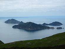
Rangitoto Islands as seen from D'Urville Island
.jpg)
Jag Rocks (Central) to the east of Rangitoto Islands (LHS)
The group consists of Wakaterepapanui Island (225 m or 738 ft), Tinui Island (190 m or 620 ft) and Puangiangi Island (150 m or 490 ft).
From 1957 Puangiangi Island was inhabited solely by Ross Webber, who recently sold it.[1]
Coordinates: 40°46′03″S 173°58′56″E / 40.7674°S 173.9822°E
See also
References
External links
This article is issued from Wikipedia - version of the 1/25/2015. The text is available under the Creative Commons Attribution/Share Alike but additional terms may apply for the media files.