Red River of the South
| Red River (Bah'hatteno[1]) | |
| Rivière Rouge (former French name) | |
| River | |
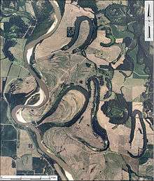
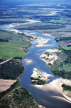 Red River looking east, north of Bonham, Texas:
Texas is to the right, Oklahoma is on the left, and the border between the two states runs along the south (right) bank of the river. | |
| Country | United States |
|---|---|
| States | Texas, Oklahoma, Arkansas, Louisiana |
| Part of | Mississippi River |
| Source | Confluence of Prairie Dog Town Fork and Buck Creek |
| - location | Harmon County, Oklahoma |
| - elevation | 1,535 ft (468 m) |
| - coordinates | 34°34′35″N 99°57′54″W / 34.57639°N 99.96500°W |
| Mouth | Atchafalaya/Mississippi River |
| - location | West Feliciana Parish, Louisiana |
| - elevation | 30 ft (9 m) |
| - coordinates | 31°01′10″N 91°44′52″W / 31.01944°N 91.74778°WCoordinates: 31°01′10″N 91°44′52″W / 31.01944°N 91.74778°W |
| Length | 1,360 mi (2,189 km) |
| Basin | 65,595 sq mi (169,890 km2) |
| Discharge | for mouth; max and min at Alexandria, LA |
| - average | 57,000 cu ft/s (1,614 m3/s) |
| - max | 233,000 cu ft/s (6,598 m3/s) |
| - min | 1,472 cu ft/s (42 m3/s) |
 Map of the Red River watershed | |
The Red River, or sometimes the Red River of the South, is a major tributary of the Mississippi and Atchafalaya rivers in the southern United States of America.[2] The river was named for the red-bed country of its watershed. It is one of several rivers with that name.
"The Mexicans and Indians on the borders of Mexico are in the habit of calling any river, the waters of which have a red appearance, 'Rio Colorado', or Red river", observed R.B. Marcy in 1853.[3] The Red River formed part of the US-Mexico border from the Adams-Onís Treaty (in force 1821) until the Texas Annexation and the Treaty of Guadalupe Hidalgo.
The Red River is the second-largest river basin in the southern Great Plains.[4] It rises in two branches (forks) in the Texas Panhandle and flows east, where it acts as the border between the states of Texas and Oklahoma. It forms a short border between Texas and Arkansas before entering Arkansas, turning south near Fulton, Arkansas and flowing into Louisiana, where it flows into the Atchafalaya River. The total length of the river is 1,360 miles (2,190 km), with a mean flow of over 57,000 cubic feet per second (1,600 m3/s) at the mouth.
Geography
Course
The Red River rises near the edge of the northwestern dip slope of the Llano Estacado mesa[5] in two forks in northern Texas and southwestern Oklahoma. The southern and largest fork, which is about 120 miles (190 km) long, is generally called the Prairie Dog Town Fork. It is formed in Randall County, Texas, near the county seat of Canyon, by the confluence of intermittent Palo Duro Creek and Tierra Blanca Creek. (The names mean "Hard Wood" and "White Land", respectively, in Spanish.)
The Red River turns and flows southeast through Palo Duro Canyon in Palo Duro Canyon State Park at an elevation of 3,440 feet (1,050 m),[4] then past Newlin, Texas, to meet the Oklahoma state line. Past that point, it is generally considered the main stem of the Red River. Near Elmer, Oklahoma, the North Fork finally joins, and the river proceeds to follow a winding course east through one of the most arid parts of the Great Plains, receiving the Wichita River as it passes the city of Wichita Falls. Near Denison, the river exits the eastern end of Lake Texoma, a reservoir formed by the Denison Dam. The lake is also fed by the Washita River from the north.
After the river flows out of the southeastern end of the lake, it runs generally east towards Arkansas and receives Muddy Boggy Creek before turning southward near Texarkana.
Soon after, the river crosses south into Louisiana. The sister cities of Shreveport and Bossier City were developed on either bank of the river, as did the downriver cities of Alexandria and Pineville; the river later broadens into a complex network of marshlands surrounding the Mississippi and Atchafalaya Rivers, where it is joined by the Ouachita River, its largest tributary. Its waters eventually discharge into the Atchafalaya River[6] and flow eastward or southward into the Gulf of Mexico.
In 1946, the Red River flood spilled over into Pineville because of insufficient levee height and strength. However, the taller and stronger levee held in Alexandria. Willie E. Kees, Jr., the young newly elected mayor of Pineville, set forth to bring the levee on the eastern side of the river on par with that in Alexandria.[7]
Tributaries
Tributaries include the Little Red River, Prairie Dog Town Fork Red River, Salt Fork Red River, North Fork Red River, Pease River, Washita River, Kiamichi River, Little Wichita River, Little River, Sulphur River, Loggy Bayou (through Lake Bistineau and Dorcheat Bayou) as well as the Ouachita River (also known as the Black River at that point) not far (at Acme, Louisiana) from the mouth.
Watershed
The Red River's watershed covers 65,590 square miles (169,900 km2)[4] and is the southernmost major right tributary of the Mississippi, and the southernmost major river system in the Great Plains. Its drainage basin is mostly in the states of Texas and Oklahoma, but also covers parts of Arkansas and Louisiana. Its basin is characterized by flat, fertile agricultural land, with only a few major cities. The drainage basin of the Red River is very arid and receives little precipitation. As a result, much of the river above the Texas-Oklahoma border is intermittent, and until the river is past its great bend south in Arkansas, the flow varies widely. Most of the agriculture in the basin is sustained by groundwater, which is recharged with rainfall and riverflow. The lower course of the river flows through a series of marshes and swamps, where its flow is dramatically moderated.
History
Native Americans
Native American cultures along the river were diverse, developing specialized adaptations to the many different environments.[4] By the time of European contact, the eastern Piney Woods were dominated by the numerous historic tribes of the Caddoan Confederacy. They found plentiful game and fish, and also had good land for cultivating staple crops.[4] The middle part of the Red River was dominated by Wichita and Tonkawa. This area was prairie, where Native Americans constructed portable and temporary tepees for housing. They practiced limited farming and followed game in seasonal, nomadic hunting cycles.[4] The Plains division of the Lipan Apache dominated the western Red River area until the 18th century, when they were displaced by invading Comanche from the north.[4]
European-American exploration and settlement
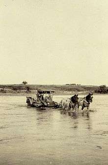
In 1806, President Thomas Jefferson commissioned the Red River Expedition to explore parts of the new lands of the Louisiana Purchase by traveling up the Red River. He said it was "in truth, next to the Missouri, the most interesting water of the Mississippi", in a letter to William Dunbar.[8] Having threaded the maze of bayous at the river's confluence, and the "Great Raft" of lodged driftwood, the expedition, was stopped by the Spanish near what is now New Boston, Texas.
In 1806, Lieutenant Zebulon Pike, under orders to ascertain the source of the Red River, ascended the Arkansas River, made his way downstream on what turned out to be the Rio Grande, and was sent home by the Spanish authorities. A more successful exploration of the river's upper reaches to both its sources was the 1852 expedition under Capt. Randolph Barnes Marcy, assisted by Brevet Capt. George B. McClellan.[9] The latter was important as a general in the American Civil War.
In April 1815, Captain Henry Miller Shreve was the first person to bring a steamboat, the Enterprise, up the Red River. Fulton and Livingston, who claimed the exclusive right to navigate Louisiana waters by steamboat, sued Shreve in the District Court of New Orleans. The judge ruled that the monopoly claimed by the plaintiffs was illegal. That decision, along with a similar outcome in Gibbons v. Ogden freed navigation on every river, lake or harbor in the United States from interference by monopolies.[10]
When John Quincy Adams became Secretary of State in 1817, one of his highest priorities was to negotiate the boundaries of the Louisiana Purchase with Spain. He negotiated with the Spanish Minister to the United States, Luis de Onis, and finally concluded Adams-Onis Treaty, also known as the Treaty of 1819. The treaty defined the south bank of the river as the boundary between the United States and Spain. That boundary continued to be recognized when Mexico gained its independence from Spain, then again when Texas became independent from Mexico. It remains so until the present, being the border between Texas and Oklahoma.[10]
In Louisiana, the area of present-day Natchitoches Parish was settled by French Creole and mixed-race Louisiana Creole people, starting before 1800. The Cane River National Heritage Area marks this area of influence, with plantations and churches founded by Louisiana Creoles. Some of the sites are designated as destinations on the Louisiana African American Heritage Trail, designed in the 21st century. For nearly 100 years after the American Civil War, some of the plantations were the center of a large African American and Creole community life, whose people lived and worked in this area for generations.
The area along the lower Red River of Grant Parish, Louisiana, and neighboring parishes were a mixture of hill country and cotton plantations, with white planters and subsistence farmers, and numerous African American slaves working the plantations in the ante bellum years. It was an area of heated social tensions and insurgency during and after the Reconstruction era. Grant was a new parish created by the Reconstruction legislature, which was trying to increase Republican Party representation. In 1873, Grant Parish was the site of the Colfax massacre, caused by the political tension and violence arising from the disputed 1872 gubernatorial election and efforts by local whites to keep white supremacy. White militias, organized from nearby parishes, killed more than 100 freedmen, some of whom had surrendered as prisoners.
In 1874, such militias organized as the White League in Grant Parish, and other chapters were soon founded across the state. The Coushatta Massacre was attributed to the White League, which attacked Republican officeholders to run them out of office. The paramilitary groups intimidated and terrorized freedmen to keep them from the polls, and by the late 1870s, conservative Democrats had retaken political control of the state.
Great Raft
In the early 19th century, settlers found that much of the river's length in Louisiana was unnavigable because of a collection of fallen trees that formed a "Great Raft" over 160 miles (260 km) long. Captain Henry Miller Shreve began clearing the log jam in 1839. The log jam was not completely cleared until the 1870s, when dynamite became available. The river was thereafter navigable, but north of Natchitoches, it was restricted to small craft. Removal of the raft further connected the Red and Atchafalaya rivers, accelerating the development of the Atchafalaya River channel.[6]
In the 20th century, the interest group known as the Red River Valley Association was formed to lobby the United States Congress to make the river fully navigable between Alexandria and Shreveport, Louisiana. Leading supporters of the longstanding project were Louisiana Democratic senators Allen J. Ellender, J. Bennett Johnston, Jr. and Russell B. Long, the Fourth District Congressman Joseph David "Joe D." Waggonner, Jr., and the late Shreveport Mayor Littleberry Calhoun Allen, Jr. With the completion of the project, a lock system constructed by the US Army Corps of Engineers allows navigation of barge traffic as far north as Shreveport.
Greer County debate
Specialists debate whether the North Fork or the Prairie Dog Town Fork is the true stem.[4] Because of a cartographic error, the land between the north and south forks was claimed by both the state of Texas and the United States federal government. Randolph B. Marcy's expedition followed the Prairie Dog Town Fork in 1852.[4] Originally called Greer County, Texas, the US Supreme Court ruled that it belonged to the United States, which at the time oversaw the Oklahoma Territory. That territory was later incorporated into the state of Oklahoma, whose southern border now follows the south fork. Today, the southern Prairie Dog Town Fork is considered the main fork, though the North Fork is as long and normally has a greater water flow.[4]
2015 Louisiana flood
In June 2015, the Red River flooded parts of Northeast Texas, Southwest Arkansas, & Louisiana, from New Boston, Texas to just south of Alexandria, Louisiana.[11]
Recreation
In 1943, Denison Dam was built on the Red River to form Lake Texoma, a large reservoir of 89,000 acres (360 km2), some 70 miles (110 km) north of Dallas. Other reservoirs on the river's tributaries serve as flood control.
See also
|
References
- ↑ Caddo name. Meredith, Howard. "Caddo (Kadohadacho)." Oklahoma Historical Society's Encyclopedia of Oklahoma History and Culture. Retrieved 9 Sept 2012)
- ↑ Tyson, Carl N. The Red River in Southwestern History. Norman: University of Oklahoma Press, 1981. ISBN 0-8061-1659-5
- ↑ Marcy, Exploration of the Red River of Louisiana: in the year 1852... with Reports on the Natural History of the Country, Washington, 1853:04.
- 1 2 3 4 5 6 7 8 9 10 Benke, Arthur; Colbert Cushing (2005). River of North America. Academic Press. p. 1144. ISBN 9780120882533.
- ↑ John Miller Morris, El Llano Estacado: Exploration and Imagination on the High Plains, 2003.
- 1 2 Piazza, Bryan P (2014). The Atchafalaya River Basin: History and Ecology of an American Wetland. Texas A&M University Press. ISBN 978-1-62349-039-3.
- ↑ Frederick Marcel Spletstoser (2005). Talk of the Town: The Rise of Alexandria, Louisiana, and the Daily Town Talk. Baton Rouge, Louisiana: Louisiana State University Press. pp. 125–126. ISBN 0-8071-2934-8. Retrieved July 24, 2015.
- ↑ Jefferson to Dunbar, 25 May 1805, quoted in T. Lindsay Baker, ed., The Texas Red River country: the official surveys of the headwaters, 1876, 1998: "Foreword", v, and in D.L. Flores, "The Ecology of the Red River in 1806: Peter Custis and Early " The Southwestern Historical Quarterly 88,.1, (July 1984).
- ↑ R.B. Marcy, Exploration of the Red River of Louisiana: in the year 1852... with Reports on the Natural History of the Country, Washington, 1853.
- 1 2 Harbour, Emma Estill. "A Brief History of the Red River County since 1803. Chronicles of Oklahoma. Vol. 16. No. 1. March 1938. Retrieved September 7, 2013.
- ↑ http://www.msn.com/en-us/weather/topstories/with-homes-underwater-in-louisiana-recovery-teams-head-out/ar-BBkYtRO?ocid=mailsignout
External links
| Wikimedia Commons has media related to Red River of the South. |
- Randolph Marcy, Exploration of the Red River, 1852, hosted by the Portal to Texas History
- Red River from the Handbook of Texas Online
- U.S. Geological Survey Geographic Names Information System: Red River
- Oklahoma Digital Maps: Digital Collections of Oklahoma and Indian Territory
- Red River Compact Commission.
- "U.S. Supreme Court Ruling Leaves Texas High And Dry."
- Geology
- Red River Valley - Engineering Geology Mapping Program PDF files of publications about and maps of the geology of the Red River Valley
- Autin, W. J., and C. E. Pearson, 1993, Quaternary Geology and Geoarchaeology of the Lower Red River Valley: Friends of the Pleistocene South Central Cell 11 th Annual Field Conference Alexandria, Louisiana March 26-28, 1993. Friends of the Pleistocene South Central Cell and Louisiana Geological Survey, Baton Rouge, Louisiana. 183 p.