Red Wing, Minnesota
| Red Wing | |
|---|---|
| City | |
| Red Wing, Minnesota | |
|
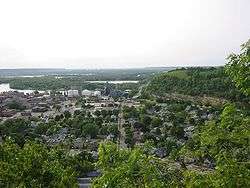
A look toward downtown Red Wing and the Mississippi River, with Barn Bluff on the right. | |
| Motto: "Come for a visit, stay for a lifetime"[1] | |
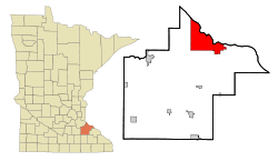 Location of the city of Red Wing within Goodhue County in the state of Minnesota | |
| Coordinates: 44°34′N 92°32′W / 44.567°N 92.533°WCoordinates: 44°34′N 92°32′W / 44.567°N 92.533°W | |
| Country | United States |
| State | Minnesota |
| County | Goodhue |
| Government | |
| • Type | Mayor - Council |
| • Mayor | Daniel D. "Dan" Bender[2] |
| Area[3] | |
| • Total | 41.19 sq mi (106.68 km2) |
| • Land | 34.60 sq mi (89.61 km2) |
| • Water | 6.59 sq mi (17.07 km2) |
| Elevation | 750 ft (226 m) |
| Population (2010)[4] | |
| • Total | 16,459 |
| • Estimate (2015)[5] | 16,445 |
| • Density | 475.7/sq mi (183.7/km2) |
| Time zone | CST (UTC-6) |
| • Summer (DST) | CDT (UTC-5) |
| ZIP code | 55066 |
| Area code(s) | 651 |
| FIPS code | 27-53620[6] |
| GNIS feature ID | 0649885[7] |
| Website | City of Red Wing |

Red Wing is a city in Goodhue County, Minnesota, United States, along the upper Mississippi River. The population was 16,459 at the 2010 census.[8] It is the county seat of Goodhue County.[9][10]
Red Wing is home to the manufacturers of nationally known products: Red Wing Shoes, Riedell Ice and Roller Skates, and Red Wing Stoneware. The Cannon Valley Trail has its eastern terminus in Red Wing. Treasure Island Resort & Casino is operated by the nearby Prairie Island Indian Reservation.
The National Trust for Historic Preservation placed Red Wing on its 2008 distinctive destinations list, which adds twelve communities annually nationwide. Red Wing was added for its "impressive architecture and enviable natural environment."[11] Red Wing is connected to Wisconsin by Red Wing Bridge (officially named the Eisenhower Bridge); it carries U.S. Route 63 over the Mississippi River and its backwaters.
This city was named after the early 19th-century Dakota Sioux chief, Red Wing (Shakea), or Hupahuduta ("Wing of the Wild Swan Dyed Red").[10][12] He was one of a succession of Mdewakanton Dakota chiefs whose name "Red Wing" came from their use of a dyed swan's wing as their symbol of rank. He was an ally of British soldiers during the War of 1812. After a vision in which he saw the Americans driving out the British, he declared neutrality. French Canadians referred to him as L'Aile Rouge. Later he took the name Shakea, or "The Man Who Paints Himself Red," after passing the name Red Wing on to a successor chief.
During the lifetime of Hupahuduta, there were few European-American pioneers in his territory. Red Wing was known as a firm friend of the United States, keeping peace with the traders and settlers, and trading for goods that were valued by his tribe. The federal government established a Mdewakanton Sioux Indian reservation in 1889 along the Mississippi River to free up land for new settlers. The city of Red Wing developed around it. This reservation is known as the Prairie Island Indian Community.
History
In the early 1850s, settlers from Mississippi River steamboats came to Red Wing to farm the lush fields in Goodhue County. They encroached on traditional territory of the Mdewakanton Sioux.
The settlers cleared the land for wheat, the annual crop of which could pay the cost of the land. Before the railroads were constructed across the territory of Goodhue County, it produced more wheat than any other county in the country. In 1873, Red Wing led the country in the amount of wheat sold by farmers.[13] The warehouses in the port of Red Wing could store and export more than a million bushels of wheat.[13]
Once the railroads connected southern Minnesota with Minneapolis and Saint Anthony, where the largest flour mills were built, the port at Red Wing lost prominence.[13]
The Aurora Ski Club in Red Wing, which was founded on February 8, 1887, was one of the first ski clubs formed in North America, reflecting skills of Scandinavian immigrants in the area. Aurora club members introduced in the 1880s, what became known as “Red Wing Style” ski techniques, which was patterned after the Telemark skiing form. The term "Red Wing style" continued in use in the United States well into the twentieth century.
The first North American ski jumping record was set by Norwegian immigrant Mikkjel Hemmestveit. His 37-foot flight in 1887 was established at the Aurora Ski Club's McSorley Hill.[14][15]
The federal government established a Mdewakanton Sioux Indian reservation in 1889 along the Mississippi River to free up land for new settlers. It is now within the boundaries of the city of Red Wing, and is known as the Prairie Island Indian Community.
The first settlers in town built small mills, factories, and workshops, similar to ones they were familiar with in New England and the upper Midwest, from where many had come.[13] Numerous immigrants from Germany, Ireland, Norway and Sweden settled in this area and were also skilled craftsmen. Some early industries were tanning and shoe-making, while other businessmen manufactured farm equipment, bricks, barrels, boats, furniture, pottery, and buttons. Consumables included beer and lumber. Service industries including stone-cutting, hospitality, and retailing.[13] The St. James Hotel remains a working token of the earlier time.[13]
Red Wing was once home to Hamline University, founded in 1854 as the first institution of higher education in the state of Minnesota. It closed in 1869 because of low enrollment due to diversion of students to the American Civil War. Chartered in St. Paul in 1871, it reopened there in 1880.
Red Wing Seminary was a Lutheran Church seminary, founded in 1879. Red Wing Seminary was the educational center for the Hauge's Norwegian Evangelical Lutheran Synod in America, commonly known as the Hauge Synod. Red Wing Seminary operated until 1917.[16]
Red Wing also was the home of Gustavus Adolphus College, a private liberal arts college of the Evangelical Lutheran Church of America (ELCA). The college was founded in Red Wing in 1862 by Eric Norelius, It moved to East Union in 1863 and then to St. Peter in 1876.
The Red Wing pottery and stoneware industry began in 1861, when county potter John Paul discovered the large, glacially deposited clay pits beds on the northwest of the city, close to Hay Creek. The first commercial pottery company, Red Wing Stoneware, was founded in 1877.[17] It used clay from the area of the Hay Creek headwaters, close to Goodhue, near a hamlet named Claybank. A railroad branch line was built to carry clay to Red Wing for this important industry. The factory buildings remain, but only traces of the railroad, abandoned in 1937, are left.[18]
20th century to present
The Minnesota Correctional Facility – Red Wing is housed in the former Minnesota State Training School, built in 1889. The original Romanesque building was designed by Warren B. Dunnell. He was the architect of a number of historical public buildings in Minnesota.
The institution was the subject of "Walls of Red Wing," a folk song by American singer-songwriter Bob Dylan (who was awarded the Nobel Prize in Literature in 2016).
In the last half of the twentieth century, the United States Army Corps of Engineers built Lock and Dam No. 3 and deepened the channel on the Mississippi River to improve navigation in this area. Such projects have revitalised Mississippi River traffic for shipping grain and coal. The port of Red Wing has gained usiness as a result. [13]
In 1973, the Prairie Island Nuclear Power Plant was opened along the river. The federal government had authorized the project in consultation with the Minnesota state government. The facility is owned and operated by Xcel Energy.
Festivals
- Rolling River Music Festival- July
- River City Days - early August
- Fall Festival of the Arts - October
- Diversity Festival - September
- Fall Festival - early November
Library
Red Wing Public Library is a member of Southeastern Libraries Cooperating, the SE Minnesota library region.[19]
Neighborhoods
The city of Red Wing has several neighborhoods or other places annexed by the city. These include:
Geography
According to the United States Census Bureau, the city has a total area of 41.19 square miles (106.68 km2), of which 34.60 square miles (89.61 km2) is land and 6.59 square miles (17.07 km2) is water.[3] The city is at the northern edge of the Driftless Area of karst topography.
Demographics
| Historical population | |||
|---|---|---|---|
| Census | Pop. | %± | |
| 1860 | 1,250 | — | |
| 1870 | 4,260 | 240.8% | |
| 1880 | 5,876 | 37.9% | |
| 1890 | 6,294 | 7.1% | |
| 1900 | 7,525 | 19.6% | |
| 1910 | 9,048 | 20.2% | |
| 1920 | 8,637 | −4.5% | |
| 1930 | 9,629 | 11.5% | |
| 1940 | 9,962 | 3.5% | |
| 1950 | 10,645 | 6.9% | |
| 1960 | 10,528 | −1.1% | |
| 1970 | 10,441 | −0.8% | |
| 1980 | 13,736 | 31.6% | |
| 1990 | 15,134 | 10.2% | |
| 2000 | 16,116 | 6.5% | |
| 2010 | 16,459 | 2.1% | |
| Est. 2015 | 16,445 | [20] | −0.1% |
| U.S. Decennial Census[21] 2015 Estimate[5] | |||
2010 census
As of the census[4] of 2010, there were 16,459 people, 7,017 households, and 4,328 families residing in the city. The population density was 475.7 inhabitants per square mile (183.7/km2). There were 7,539 housing units at an average density of 217.9 per square mile (84.1/km2). The racial makeup of the city was 91.5% White, 1.9% African American, 2.2% Native American, 0.8% Asian, 1.2% from other races, and 2.3% from two or more races. Hispanic or Latino of any race were 3.7% of the population.
There were 7,017 households of which 28.0% had children under the age of 18 living with them, 46.6% were married couples living together, 10.6% had a female householder with no husband present, 4.5% had a male householder with no wife present, and 38.3% were non-families. 32.2% of all households were made up of individuals and 14.6% had someone living alone who was 65 years of age or older. The average household size was 2.27 and the average family size was 2.84.
The median age in the city was 41.8 years. 22.5% of residents were under the age of 18; 7.8% were between the ages of 18 and 24; 23.9% were from 25 to 44; 27.7% were from 45 to 64; and 18.2% were 65 years of age or older. The gender makeup of the city was 48.6% male and 51.4% female.
2000 census
At the census[6] of 2000, there were 16,116 people, 6,562 households, and 4,166 families in the city. The population density was 455.3 per square mile (175.8 km²). There were 6,867 housing units at an average density of 194.0 per square mile (74.9/km²). The racial makeup was 94.33% White, 1.32% African American, 2.22% Native American, 0.74% Asian, 0.05% Pacific Islander, 0.53% from other races, and 0.82% from two or more races. Hispanic or Latino of any race were 1.27% of the population.
There were 6,562 households, of which 30.4% had children under 18 with them, 51.2% were married couples living together, 8.9% had a female householder with no husband present, and 36.5% were non-families. 30.7% of all households were of individuals and 13.3% had someone living alone 65 or older. The average household size was 2.35 and the average family 2.94.
In the city, the population was 24.6% under 18, 8.2% from 18 to 24, 27.5% from 25 to 44, 23.2% from 45 to 64, and 16.5% 65 or older. The median was 39. For every 100 females there were 93.5 males. For every 100 females 18 and over, there were 90.6 males.
The median income for a household was $43,674, and the median for a family was $54,641. Males had a median of $36,576 versus $25,477 for females. The per capita income was $21,678. About 3.9% of families and 6.8% of the population were below the poverty line, including 7.9% of those under age 18 and 8.0% of those 65 or over.
Transportation
U.S. Routes 61 and 63 and Minnesota State Highways 19 and 58 are the main intercity highways. Minnesota State Highway 292 also is in the city.
Red Wing Regional Airport is located across the Mississippi River in Pierce County, Wisconsin, near Wisconsin Highway 35 .
Red Wing's Amtrak station is served by Amtrak's Empire Builder daily in each direction between Chicago to the east, and Seattle and Portland on the west.
Government

Mayor
- Daniel Bender[22]
- Term: June 2013 to January 2017
City council
The city council members as of January 2015 are:[23]
- Jason Sebion (First Ward)
- Term: January 2013 to January 2017
- Lisa Pritchard Bayley (Second Ward)
- Council President
- Term: January 2013 to January 2017
- Dean Hove, Council President (First & Second Wards)
- Term: January 2015 to January 2019
- Dan Munson (Third Ward)
- Term: January 2015 to January 2019
- Peggy Rehder (Fourth Ward)
- Term: January 2015 to January 2019
- Ralph Rauterkus (Third & Fourth Wards)
- Council Vice President
- Term: January 2013 to January 2017
- Dustin Schulenberg (At-Large)
- Term: January 2015 to January 2019
Notable people
- Eugenie Anderson (1909–1997), U.S. Ambassador to Denmark and Bulgaria; first woman appointed U.S. ambassador
- Ryan Boldt (born 1994), baseball player[24]
- Joseph Francis Busch (1866–1953), Roman Catholic Bishop
- William C. Christianson (1892–1985), Minnesota Supreme Court justice
- William J. Colvill, (1830–1905), Civil War hero and Minnesota Attorney General
- Frances Densmore (1867–1957), ethnographer and ethnomusicologist
- Joanell Dyrstad (born 1942), former Minnesota lieutenant governor (1991–1995)
- Patrick Flueger (born 1983), actor, The Princess Diaries, The 4400
- Mikkjel Hemmestveit (1863–1957), skiing champion
- Torjus Hemmestveit (1860–1930), skiing champion
- Stanley E. Hubbard (1897-1992), founder of Hubbard Broadcasting
- Philander P. Humphrey (1823–1862), physician, politician
- Ned Locke (1919-1992), television personality, Bozo's Circus
- Martin Maginnis (1841–1919), politician, Union Army veteran
- Greg Norton (born 1959), bassist for Hüsker Dü and restaurateur
- Henrietta Barclay Paist (1870–1930), artist, designer, teacher, and author
- Robert Ezra Park (1864–1944), urban sociologist
- John Pohl (born 1979), player in NHL, Toronto Maple Leafs
- Theodore Swanson (1873–1959), farmer, Wisconsin legislator
- James Touchi-Peters (born 1956), symphonic conductor, composer and jazz singer
- August Weenaas (1835–1924), founding President of Augsburg College
- Jacqueline West (born 1979), poet and author of the The Books of Elsewhere
- Phyllis Yes (born 1941), feminist artist
- Free Energy (band)
Sister cities
Red Wing has three sister cities, as designated by Sister Cities International:
See also
References
- ↑ "City of Red Wing Minnesota". City of Red Wing Minnesota. Retrieved October 9, 2012.
- ↑ "Office of the Mayor". City of Red Wing. Retrieved 2015-07-22.
- 1 2 "US Gazetteer files 2010". United States Census Bureau. Retrieved 2012-11-13.
- 1 2 "American FactFinder". United States Census Bureau. Retrieved 2012-11-13.
- 1 2 "Population Estimates". United States Census Bureau. Retrieved June 17, 2016.
- 1 2 "American FactFinder". United States Census Bureau. Retrieved 2008-01-31.
- ↑ "US Board on Geographic Names". United States Geological Survey. 2007-10-25. Retrieved 2008-01-31.
- ↑ "2010 Census Redistricting Data (Public Law 94-171) Summary File". American FactFinder. United States Census Bureau. Retrieved 27 April 2011.
- ↑ "Find a County". National Association of Counties. Retrieved 2011-06-07.
- 1 2 "Profile for Red Wing, Minnesota, MN". ePodunk. Retrieved October 9, 2012.
- ↑ "Red Wing, Minnesota". Dozen Distinctive Destinations 2008. National Trust for Historic Preservation. 2008. Retrieved 2008-03-26.
- ↑ O'Connor, Mark (July 15, 2011). "Red Wing". The O'Connor Method - A New American School of String Playing. New American School of String Playing. II. Retrieved July 8, 2013.
- 1 2 3 4 5 6 7 Gilman, Rhonda R. (1989). The Story of Minnesota's Past. Saint Paul, Minnesota: Minnesota Historical Society Press. pp. 12–21. ISBN 0-87351-267-7.
- ↑ "''Mikkel Hemmestvedt'' (Alpenglow Ski Mountaineering History Project)". Alpenglow.org. Retrieved 2013-07-16.
- ↑ "''The Aurora Ski Club. Red Wing, Minnesota 1886-1951'' (SkiJumpingUSA.com)". Skijumpingcentral.com. 2007-02-02. Retrieved 2013-07-16.
- ↑ Red Wing Seminary; fifty years of service. (Published on the occasion of the fiftieth anniversary, September 15 to 17, 1929. Editor-in-chief, Arthur Rholl. 1930)
- ↑ "Timeline of Pottery production in Red Wing, MN" http://www.redwingcollectors.org/images/red%20wingsrichpotteryhistorybygarytefft%26stacywegner.pdf
- ↑ Chicago Great Western Railway Co. Safety News, 30 June 1968
- ↑ "''Southeastern Libraries Cooperating (SELCO)''". Selco.info. Retrieved 2013-07-16.
- ↑ "Annual Estimates of the Resident Population for Incorporated Places: April 1, 2010 to July 1, 2015". Retrieved July 2, 2016.
- ↑ United States Census Bureau. "Census of Population and Housing". Retrieved November 26, 2014.
- ↑ http://www.red-wing.org/news/article584.html
- ↑ "Elected officials". Red-wing.org. Retrieved 2013-07-16.
- ↑ Brett BoeseThe Post-Bulletin, Rochester MN (February 10, 2012). "Red Wing's Boldt chooses Nebraska, family". PostBulletin.com. Retrieved April 16, 2016.
Other sources
- Sky Crashers: A History of the Aurora Ski Club (Goodhue County Historical Society: 2004)
- Red Wing Reflections of a River Town (Red Wing Republican Eagle: 2007)
External links
| Wikimedia Commons has media related to Red Wing, Minnesota. |
| Wikisource has the text of the 1911 Encyclopædia Britannica article Red Wing. |
- City of Red Wing, MN -- Official site and alternate link
- Red Wing Visitors and Convention Bureau -- Visitor Information
- Red Wing Chamber of Commerce
- Downtown Red Wing
- Red Wing Pottery Collectors Society
- Red Wing Pottery Collectors Foundation & Museum
- Red Wing High School
- Red Wing FFA Chapter
- Sports and Recreation at the turn of the 20th Century
Municipalities and communities of Goodhue County, Minnesota, United States | ||
|---|---|---|
| Cities | 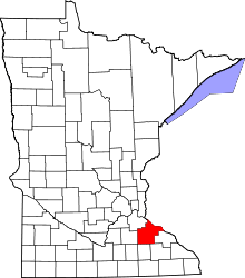 | |
| Townships | ||
| CDP | ||
| Unincorporated communities | ||
| Indian reservation | ||
| Footnotes | ‡This populated place also has portions in an adjacent county or counties | |