Redeye River
| Redeye River | |
| River | |
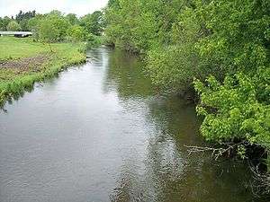 The Redeye River in Sebeka in 2007 | |
| Country | United States |
|---|---|
| State | Minnesota |
| Source | Wolf Lake |
| - location | Toad Lake Township, Becker County |
| - elevation | 1,532 ft (467 m) [1] |
| - coordinates | 46°49′17″N 95°25′06″W / 46.82139°N 95.41833°W [2] |
| Mouth | Leaf River |
| - location | Bullard Township, Wadena County |
| - elevation | 1,263 ft (385 m) [1] |
| - coordinates | 46°29′10″N 94°53′06″W / 46.48611°N 94.88500°WCoordinates: 46°29′10″N 94°53′06″W / 46.48611°N 94.88500°W [2] |
| Length | 73 mi (117 km) [3] |
| Basin | 222 sq mi (575 km2) [3] |
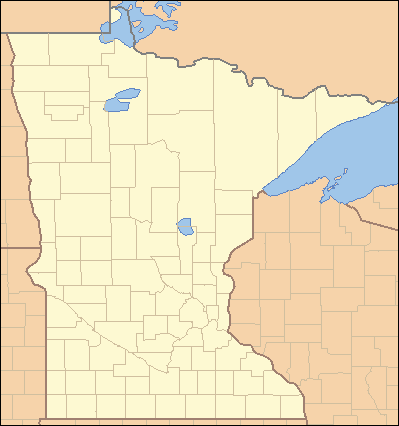 Location of the mouth of the Redeye River | |
The Redeye River is a tributary of the Leaf River, 73 miles (117 km) long, in central Minnesota in the United States. Via the Leaf and Crow Wing Rivers, it is part of the watershed of the Mississippi River, draining an area of 222 square miles (575 km²) in a rural region. The river's name comes from the Native Americans of the area, who saw many red-eye fish in the river.[4]
Geography
The Redeye River rises in a morainic region,[5] issuing from Wolf Lake in Toad Lake Township in southeastern Becker County. It flows generally southeastwardly through northeastern Otter Tail and central Wadena Counties, through the city of Sebeka, and enters the Leaf River in Bullard Township in southeastern Wadena County,[6] eight miles (13 km) upstream of the Leaf River's mouth at the Crow Wing River.[3] The river's course is within the North Central Hardwood Forest ecoregion, which is characterized by hardwood forests of maple and basswood mixed with conifers, on outwash plains and moraines amid flat glacial lakes.[7]
See also
References
- 1 2 Google Earth elevation for GNIS coordinates. Retrieved on 2007-06-17.
- 1 2 "Geographic Names Information System entry for Redeye River (Feature ID #649894)". Geographic Names Information System. Retrieved 2007-06-17.
- 1 2 3 Sanocki, C. A.; B. C. Fischer (2000). "Physical Characteristics of Stream Subbasins in the Redeye (Leaf) River Basin, Central Minnesota" (PDF). United States Geological Survey. Retrieved 2007-06-17.
- ↑ Upham, Warren. "Minnesota Place Names: A Geographical Encyclopedia.". Minnesota Historical Society. Retrieved 2010-04-02.
- ↑ Waters, Thomas F. (2006). "The Crow Wing: Oxcart to Canoe". The Streams and Rivers of Minnesota. Minneapolis: University of Minnesota Press. pp. 184–194. ISBN 0-8166-0960-8.
- ↑ Minnesota Atlas & Gazetteer. Yarmouth, Me.: DeLorme. 1994. pp. 53, 60–61. ISBN 0-89933-222-6.
- ↑ "Upper Mississippi River Basin.". Minnesota Pollution Control Agency. 2000. pp. Upper Mississippi River Basin Water Quality Plan, Headwaters to the Rum River - Anoka, Section III: Upper Mississippi River Basin. Retrieved 2007-06-17.