Redoubt Mountain
For other uses, see Mount Redoubt (disambiguation).
| Redoubt Mountain | |
|---|---|
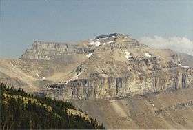 Redoubt Mountain, August 1994. Viewpoint from Hidden Lake. | |
| Highest point | |
| Elevation | 2,902 m (9,521 ft) [1][2] |
| Prominence | 570 m (1,870 ft) [3] |
| Coordinates | 51°28′06″N 116°04′42″W / 51.46833°N 116.07833°WCoordinates: 51°28′06″N 116°04′42″W / 51.46833°N 116.07833°W [3] |
| Geography | |
| Parent range | Slate Range |
| Topo map | NTS 82N/08 |
| Climbing | |
| First ascent | 1906[3] |
| Easiest route | moderate/difficult scramble |
Redoubt Mountain (alternatively Mount Redoubt) is a mountain located in Banff National Park, Alberta, Canada. It forms the southern buttress of Boulder Pass.
The mountain was named in 1908 by Arthur O. Wheeler, founding member of the ACC, as it resembled a redoubt (an outer military defense).[1]
The mountain can be climbed on a moderate to difficult scrambling route on the northwestern ridge.[4]
References
- 1 2 "Redoubt Mountain". PeakFinder.com. Retrieved 2007-08-31.
- ↑ Lake Louise & Yoho (Map). 1:50,000. Gem Trek Publishing. 2001. § B5. ISBN 1-895526-15-9.
- 1 2 3 "Redoubt Mountain". Bivouac.com. Retrieved 2009-01-02.
- ↑ Alan Kane (1999). "Mount Redoubt". Scrambles in the Canadian Rockies. Rocky Mountain Books. p. 255. ISBN 0-921102-67-4.
This article is issued from Wikipedia - version of the 5/24/2015. The text is available under the Creative Commons Attribution/Share Alike but additional terms may apply for the media files.