Reedsville Formation
| Reedsville Formation Stratigraphic range: Late Ordovician | |
|---|---|
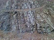 Outcrop of Reedsville Formation on south side of U.S. Route 522, Blacklog Gap, Huntingdon County, Pennsylvania. | |
| Type | sedimentary |
| Unit of | Chickamauga Group (TN only)[1] |
| Underlies | Bald Eagle Formation |
| Overlies | Coburn Formation in PA, Trenton Limestone in TN and WV |
| Lithology | |
| Primary | shale |
| Other | sandstone |
| Location | |
| Region | Appalachian Mountains |
| Extent | Pennsylvania, Maryland, Virginia, West Virginia, eastern Tennessee |
| Type section | |
| Named for | Reedsville, Pennsylvania |
| Named by | E. O. Ulrich[2] |
The Ordovician Reedsville Formation is a mapped surficial bedrock unit in Pennsylvania, Maryland, Virginia, West Virginia, and Tennessee, that extends into the subsurface of Ohio. This rock is a slope-former adjacent to (and stratigraphically below) the prominent ridge-forming Bald Eagle sandstone unit in the Appalachian Mountains. It is often abbreviated Or on geologic maps.
Description
The Reedsville Formation is an olive-gray to dark-gray siltstone, shale, and fine-grained sandstone.[3] In Central Pennsylvania along the Nittany Arch, and extending into the subsurface of northern West Virginia, the base of the Reedsville formation includes the black calcareous Antes Shale formation.[4]
Type section
The type locality is at Reedsville, Pennsylvania.
Age
Relative age dating of the Reedsville places it in the Upper Ordovician. It rests conformably atop the Upper Ordovician Coburn Formation at the top of the Trenton Group limestone and conformably below the Bald Eagle Formation.[5]
Isotopic dating of shale mylonite in Pennsylvania reveals a K-Ar age of 372+/-8 Ma.[6]
Economic uses
The Reedsville is quarried locally in borrow pits for road material and fill.[7]
References
- ↑ Harris, L.D., 1965, Geologic map of the Wheeler quadrangle, Claiborne County, Tennessee, and Lee County, Virginia: U.S. Geological Survey Geologic Quadrangle Map, GQ-435, 1 sheet, scale 1:24,000 http://ngmdb.usgs.gov/Prodesc/proddesc_903.htm
- ↑ Ulrich, E.O., 1911, Revision of the Paleozoic systems: Geological Society of America Bulletin, v. 22, p. 281-680.
- ↑ Berg, T.M., Edmunds, W.E., Geyer, A.R. and others, compilers, (1980). Geologic Map of Pennsylvania: Pennsylvania Geologic Survey, Map 1, scale 1:250,000.
- ↑ Robert T. Ryder (1991). Stratigraphic Framework of Cambrian and Ordovician Rocks in the Central Appalachian Basin From Richland County, Ohio, To Rockingham County, Virginia (PDF) (Map). U.S. Geological Survey.
- ↑ Gold, David P. & Doden, Arnold G. "Geological Report on the Skytop Road Cuts". Geosciences: Feature Article. Pennsylvania State University College of Earth and Mineral Sciences. Retrieved 2008-01-26.
- ↑ Lapham, D.M., and Root, S.I., 1971, Summary of isotopic age determinations in Pennsylvania: Pennsylvania Geological Survey Information Circular, 4th series, no. 70, 29 p.
- ↑ Doden, Arnold G. & Gold, David P. (2008). "Bedrock Geologic Map of The Mc Alevys Fort Quadrangle, Huntingdon, Centre, and Mifflin Counties, Pennsylvania" (pdf). Pennsylvania Geological Survey.