Reynolds Bridge
| Reynolds Bridge | |
|---|---|
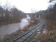 View from south | |
| Coordinates |
41°39′11″N 73°4′37″W / 41.65306°N 73.07694°WCoordinates: 41°39′11″N 73°4′37″W / 41.65306°N 73.07694°W |
|
Reynolds Bridge | |
| Area | less than one acre |
| Built | 1928 |
| Architect | Connecticut Highway Department; Haggerty, Charles A. |
| Architectural style | open-spandrel concrete arch |
| NRHP Reference # | 04001095[1] |
| Added to NRHP | September 29, 2004 |
| Carries | State Road 848 (Waterbury Road) |
| Crosses | Naugatuck River |
| Locale | Thomaston, Connecticut |
| Official name | Bridge No. 603 |
| Maintained by | Connecticut Department of Transportation |
| Characteristics | |
| Total length | 148.7 m |
| Statistics | |
| Daily traffic | 3,100 |
The Reynolds Bridge in Thomaston, Connecticut is an open-spandrel concrete arch bridge carrying Waterbury Road (unsigned State Road 848) over the Naugatuck River. It was built in 1928 and was listed on the National Register of Historic Places in 2004.[1]
It also spans the tracks of what was the New Haven Railroad, and is now the Naugatuck Railroad, which run along the river.
At the time of its construction, open-spandrel design was used for the longest concrete bridge crossings, and this was the longest designed by the Connecticut State Highway Department.[2]
As of 2004, it was one of six open-spandrel bridges in Connecticut.[2]:6? The Cornwall Bridge, built later over the Housatonic River, has a longer span.[2]:7
See also
- Cornwall Bridge
- Washington Bridge
- National Register of Historic Places listings in Litchfield County, Connecticut
- List of bridges on the National Register of Historic Places in Connecticut
References
- 1 2 National Park Service (2009-03-13). "National Register Information System". National Register of Historic Places. National Park Service.
- 1 2 3 Bruce Clouette (March 31, 2003). "National Register of Historic Places Registration: Reynolds Bridge / Bridge No. 603" (PDF). National Park Service. and Accompanying 8 photos, from 2003
| Topics | |
|---|---|
| Lists by states |
|
| Lists by insular areas | |
| Lists by associated states | |
| Other areas | |
| |