Rimatara
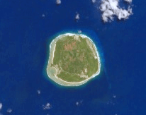 NASA picture of Rimatara Island | |
 Rimatara | |
| Geography | |
|---|---|
| Location | Pacific Ocean |
| Coordinates | 22°39′0″S 152°49′12″W / 22.65000°S 152.82000°W |
| Archipelago | Australes |
| Area | 8.6 km2 (3.3 sq mi) |
| Highest elevation | 83 m (272 ft) |
| Highest point | Mount Uahu |
| Administration | |
|
France | |
| Overseas collectivity | French Polynesia |
| Administrative subdivision | Australes |
| Commune | Rimatara |
| Largest settlement | Amaru |
| Demographics | |
| Population | 873[1] (2012) |
| Pop. density | 102 /km2 (264 /sq mi) |
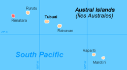
Rimatara is the westernmost inhabited island in the Austral Islands of French Polynesia. It is located 550 km (340 mi) south of Tahiti and 150 km (93 mi) west of Rurutu. The commune of Rimatara includes the small and uninhabited Maria Islands.
Rimatara is a circular volcanic plateau surrounded by a reef with a height of 8 to 10 meters (26 to 32 feet). The highest point, at the peak of Mount Uhau, is 83 meters (272 feet). The main villages are Amaru (the capital), Anapoto and Mutuaura.
Rimatara was one of the last Polynesia islands to welcome European visitors. Captain Samuel Pinder Henry discovered the island in 1821. Two missionaries arrived in 1822 and established a Protestant mission. France established a protectorate in 1889[2] and annexed Rimatara in 1900.[3][4]
Administration
| Rimatara | ||
|---|---|---|
| ||
 | ||
| Coordinates: 22°39′S 152°49′W / 22.65°S 152.82°WCoordinates: 22°39′S 152°49′W / 22.65°S 152.82°W | ||
| Country | France | |
| Overseas collectivity | French Polynesia | |
| Government | ||
| • Mayor | Georges Hatitio | |
| Area1 | 9.13 km2 (3.53 sq mi) | |
| Population (2012)2 | 873 | |
| • Density | 96/km2 (250/sq mi) | |
| INSEE/Postal code | 98743 / 98752 | |
| Elevation | 0–83 m (0–272 ft) | |
|
1 French Land Register data, which excludes lakes, ponds, glaciers > 1 km² (0.386 sq mi or 247 acres) and river estuaries. 2 Population without double counting: residents of multiple communes (e.g., students and military personnel) only counted once. | ||

The commune of Rimatara consists of the island of Rimatara, and the Maria Islets (Îlots Maria). Rimatara consists of the following associated communes:
- Amaru
- Anapoto
- Mutuaura
References
- ↑ "Population". Institut de la statistique de la Polynésie française (in French). Retrieved 9 January 2015.
- ↑ Annuaire des établissements français de l'Océanie pour 1892. Imp. du gouvenement. 1892. p. 112.
- ↑ Ch Mourey, Louis Brunel, ed. (1902). "Annexion de l'île Rurutu et dépendances". L'Année Coloniale. 3. C. Tallandier. p. 232.
- ↑ Great Britain, Foreign and Commonwealth Office, ed. (1904). British and Foreign State Papers, Volume 94. Harrison and Sons, London. pp. 1304–1305.
- "Presidency of French Polynesia - Rimatara". Archived from the original on 2007-06-23. Retrieved 2007-10-04.
External links
| Wikimedia Commons has media related to Rimatara. |
- http://www.thetahititraveler.com/islandguide/rimataraintro.asp
- (French) http://www.iero.org/sites/fenua/australes/rimatara/index.html