Rincón de Tres Cerros
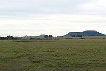
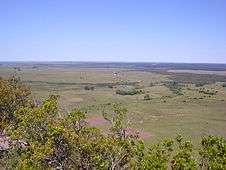
Rincón de Tres Cerros (literally "corner of the three hills") is an area in Rivera Department of Uruguay, wedged between Tacuarembó River and stream Arroyo Cuñapirú (hence the toponym "corner"). The area owes its name to the three flat "mesas" or butte hills (cerros) aligned in a row, from the biggest in the South to the smallest in the north, which dominate the horizon. Their names are: "Cerro Zapato" or "Alpargata" (meaning "shoe", because of its shape, as seen from above), the biggest of the three, "Cerro del Medio" (meaning "hill of the middle") and "Cerro Chapeu" (meaning "hat" in Portuguese), being the smallest. The hills are mostly bare except for a few native woodland trees around the brim of the "table tops". Cerro Zapato has some Eucalyptus trees that were planted along its north-eastern flank and the eastern part of its top surface. Access to the area is made difficult by sporadic flooding which cuts off the main access bridges (Paso Rogelio over the Tacuarembó river, and Paso Cunha over the stream Arroyo Cuñapirú) that cross the two rivers. This flooding has become much less frequent in recent years due to extensive planting of Eucalyptus and Pine forests, especially in the Tacuarembó river basin.
Images
 Southeast view from Cerro Zapato |
 Northwest view from Cerro Zapato |
Geo coordinates
- Cerro Zapato 31°37′46″S 55°37′0″W / 31.62944°S 55.61667°W
- Cerro del Medio 31°35′20″S 55°37′38″W / 31.58889°S 55.62722°W
- Cerro Chapeu 31°34′1″S 55°38′10″W / 31.56694°S 55.63611°W
External links
Coordinates: 31°37′46″S 55°37′0″W / 31.62944°S 55.61667°W