Ripapa Island
 Fort Jervois | |
| Geography | |
|---|---|
| Coordinates | 43°37′12″S 172°45′16″E / 43.6201°S 172.7544°ECoordinates: 43°37′12″S 172°45′16″E / 43.6201°S 172.7544°E |
| Administration | |
| Demographics | |
| Population | 0 |
| Additional information | |
| Official name | Fort Jervois |
| Designated | 22-Aug-1991 |
| Reference no. | 5306 |
Ripapa Island, also known locally as Ripa Island, just off the shore of Lyttelton Harbour (Whakaraupo) has played many roles in the history of New Zealand. The island initially played a key role in an internal struggle for the south island Ngāi Tahu tribe in the early 19th Century. In the late 19th century the island was used as a quarantine station for ships arriving from Britain, though 1880 saw the use of the quarantine buildings as a prison, notably for members of the Parihaka Māori settlement in Taranaki during its passive resistance campaign against the surveying and selling of its land by the government.[1] The quarantine buildings were dismantled when the Island was incorporated into the coastal defence scheme.[2]
Pre-European history
The site of Ripapa island was perfect for building a pā (a fortification built by the Māori) and in the early 19th Century, Chief Taununu of the Ngāi Tahu tribe built such a pā on the island. In the 1820s Chief Taununu faced a fierce fight with another Ngāi Tahu group, in what was to be known as the Kai Huanga feud. Kai Huanga, meaning "eat relatives", refers to the cannibalistic nature of the feud and that those they fought and ate were close relatives, even getting to a point where cousin would eat cousin.
The Ngāi Tahu tribe continued to occupy the island until around 1832. Prior to this, Chief Te Whakarukeruke who had been occupying Ripapa Island, left to help defend Kaiapoi from Te Rauparaha. After Kaiapoi fell, Te Rauparaha overran a number of pā on and around Banks Peninsula, including the pā on Ripapa Island. The island was never again occupied by the Māori.
Fort Jervois
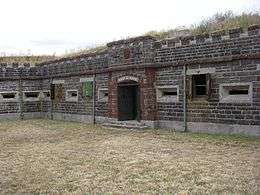
Fort Jervois was built on Ripapa as one of the four defences set up in World War I to protect Lyttelton Harbour, and as part of the nationwide coastal defences. The walled fort that had been built in 1886 had been re-militarised as a result of a perceived Russian scare and is the most complete Russian scare fort left in New Zealand. The fort was occupied by the New Zealand army from the Russian scare till the end of World War I and was again garrisoned during World War II. Fort Jervois housed some prisoners of war during World War I including Felix von Luckner.[3]
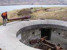
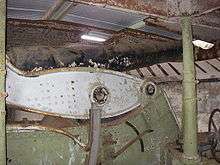
The fort is currently the home of two extremely rare guns. One is a BL 8 inch gun (one of only 12 left in the world), which is still in working order, though there are no shells left for such a weapon. It also holds a smaller BL 6 inch gun. However, at the first test shot the recoil system failed, with the result that the barrel cracked and most of the rest of the gun was damaged and was returned to England for repairs. A test fire in 1939 cracked the mounting. Though these are the only two guns currently in place at Fort Jervois, there are emplacements for another two guns. These two guns are on the island but have been partially destroyed.
The island has been under the control of the Department of Conservation since 1990. Fort Jervois is classed as a Category I historic place by the New Zealand Historic Places Trust,[4] and has been considered "actively managed" by Canterbury Conservancy. Future plans have been made to return the island to how it was during the Second World War.[2]
The June 2011 Christchurch earthquake damaged Fort Jervois and it is now closed. Once some remedial repairs are carried out, it may be opened to restricted access.[2]
See also
- Coastal fortifications of New Zealand
- History of the Canterbury Region
- List of islands of New Zealand
References
- ↑ The Taranaki Report: Kaupapa Tuatahi by the Waitangi Tribunal, chapter 7.
- 1 2 3 http://www.doc.govt.nz/conservation/historic/by-region/canterbury/christchurch-and-banks-peninsula/fort-jervois-ripapa-island/ DoC information on Ripapa Island
- ↑ Munro, Robin (14 April 2012). "War hero or a braggart?". The Press. pp. C10–C11. Retrieved 19 October 2014.
- ↑ "Fort Jervois". Register of Historic Places. Heritage New Zealand. Retrieved 25 April 2011.
External links
| Wikimedia Commons has media related to Ripapa Island. |
- Ripapa Island at the Department of Conservation