River Angas
| River Angas | |
|---|---|
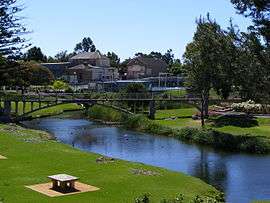 Angas River in Strathalbyn | |
| Country | Australia |
| Basin | |
| Main source |
Flaxley 35°08′18″S 138°48′25″E / 35.138322°S 138.807007°E |
| River mouth |
Lake Alexandrina Milang[1] 35°23′54″S 138°59′58″E / 35.398220°S 138.999450°ECoordinates: 35°23′54″S 138°59′58″E / 35.398220°S 138.999450°E |
| Physical characteristics | |
| Length | 26 mi (42 km)[1] |
The River Angas is a small river rising on the eastern side of the Mount Lofty Ranges in South Australia. Its headwaters are near Macclesfield and it flows generally southward through Strathalbyn, emptying into Lake Alexandrina near the town of Milang.
The river was discovered and named on 31 December 1837, during the exploration by Robert Cock, William Finlayson, A. Wyatt and G. Barton from Adelaide to Lake Alexandrina. "We gave to this river the name of Angas, in honour of the chairman of the South Australian Company, whose interest in and exertions on behalf of the colony are well known."[2]
Towns along the river include Macclesfield, Strathalbyn and Belvidere.
References
- 1 2 "Placename Details: Angas River". Property Location Browser. Government of South Australia. 15 February 2007. SA0001439. Retrieved 17 December 2015.
- ↑ Journal of an excursion from Adelaide to the River Murray and Lake Alexandrina, December 1837, by Robert Cock, Wm. Finlayson, A. Wyatt, G. Barton, South Australian Gazette and Colonial Register, Adelaide, Saturday Jan 20 1838
This article is issued from Wikipedia - version of the 6/6/2016. The text is available under the Creative Commons Attribution/Share Alike but additional terms may apply for the media files.