River Finn (County Donegal)
| River Finn | |
|---|---|
 River Finn | |
| Native name | An Fhinn |
| Etymology | Irish finn, "fair/clear" |
| Countries | Ireland & Northern Ireland |
| Cities | Clady, Tyrone |
| Basin | |
| Main source | Lough Finn, County Donegal |
| River mouth | North Channel via Lough Foyle |
| Basin size | 505 km2 (195 sq mi) |
| Physical characteristics | |
| Length | 63.17 km (39.25 mi) |
| Discharge |
|
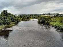
The River Finn (Irish: Abhainn na Finne[1]) is a river that flows through County Donegal in the Republic of Ireland and County Tyrone in Northern Ireland. It rises in Lough Finn in County Donegal and flows east through a deep mountain valley to Ballybofey and Stranorlar (on opposite sides of the river) and on to the confluence with the River Mourne at Lifford. From Castlefin downstream the river is tidal, becoming deeper towards Strabane.[2] The Finn is 40 miles (64 km) long and together with its tributary the Reelin River, drains a catchment area of 195 square miles.[3] The River Foyle is formed by the confluence of the River Mourne and the River Finn, west of Lifford Bridge.[4] The area which the River Finn flows through is called the Finn Valley. The village of Clady, near Strabane in County Tyrone, is on the River Finn. The football club in Ballybofey, Finn Harps, is named after the river.[5]
Angling
The upper reaches of the Reelin and the Finn are fast downstream to Ballybofey and can give excellent fishing. From Ballybofey downstream the river becomes deeper and slower. In all there is more than 25 miles (40 km) of salmon fishing on the river from Flushtown right up to Bellanmore Bridge and part of the Reelan too. There is good sea trout fishing at Liscooley and Killygordan and from Ballybofey to Bellanamore Bridge. The Finn and its tributary the Reelan are probably the most prolific salmon and grilse rivers in Donegal and indeed throughout the Foyle catchment.[3] Fish species such as roach, perch, eels and brown trout are caught in the Finn system.[2]
Area of special scientific interest
The River Foyle and tributaries Area of Special Scientific Interest (ASSI) includes the River Foyle and its tributaries i.e. that part of the River Finn which is within Northern Ireland, the River Mourne and its tributary the River Strule (up to its confluence with the Owenkillew River) and the River Derg, along with two of its sub-tributaries, the Mourne Beg River and the Glendergan River. The area encompasses 120 km of watercourse and is notable for the physical diversity and naturalness of the banks and channels, especially in the upper reaches, and the richness and naturalness of its plant and animal communities. Of particular importance is the population of Atlantic Salmon, which is one of the largest in Europe. Research has indicated that each sub-catchment within the system supports genetically distinct populations.[6]
See also
References
- ↑ http://www.logainm.ie/en/111157
- 1 2 "The River Finn". Strabane Lifford Angling Development Association. Retrieved 1 March 2009.
- 1 2 "River Finn". Discover Ireland. Retrieved 1 March 2009.
- ↑ "The Foyle". Strabane Lifford Angling Development Association. Retrieved 1 March 2009.
- ↑ http://waterlevel.ie/hydro-data/search.html?free=finn#
- ↑ "Area of Special Scientific Interest - River Foyle and Tributaries". Northern Ireland Environment Agency. Retrieved 1 March 2009.
External links
| Wikimedia Commons has media related to River Finn (County Donegal). |
Coordinates: 54°48′04″N 7°44′45″W / 54.80111°N 7.74583°W