River Pinn
| River Pinn | |
|---|---|
|
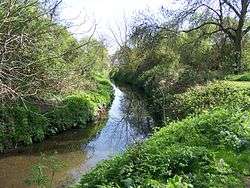
The river in Ickenham | |
| Basin | |
| Main source | Pinner |
| Progression | Frays River |
The River Pinn is a river in the county of Middlesex, in the western part of Greater London, which originates in Harrow Weald and flows into the Frays River, a distributary of the River Colne.
Route
The River Pinn runs through Pinner, Eastcote and Ruislip: the latter derives its name from "Rush leap" - this being a reference to the width of the river in the area.[1] It then runs through Ickenham and onto Uxbridge, where it passes through the grounds of RAF Uxbridge and Brunel University. The Pinn continues on to Cowley where it joins the Frays River at Yiewsley.[2]
During the Second World War the river was temporarily dammed near Pinner High Street to serve as a water supply for putting out fires from air raids.[1]
There's a 12-mile walk called the "Celandine Route" which goes through an areas of woodland, meadows, parks along the route. It finishes as the River Pinn goes underneath the Grand Union Canal. A short walk down the "Slough arm" of the Grand Union Canal brings you to the Fray's River.
See also
References
- 1 2 "River Pinn". London Borough of Hillingdon. 26 June 2007. Retrieved 14 March 2011.
- ↑ Cowley: Introduction, A History of the County of Middlesex: Volume 3: Shepperton, Staines, Stanwell, Sunbury, Teddington, Heston and Isleworth, Twickenham, Cowley, Cranford, West Drayton, Greenford, Hanwell, Harefield and Harlington (1962), pp. 170-172. Date accessed: 27 October 2008>
External links
| Wikimedia Commons has media related to River Pinn. |
Coordinates: 51°30′51″N 0°28′47″W / 51.5142°N 0.4797°W