Rock Island County, Illinois
| Rock Island County, Illinois | |
|---|---|
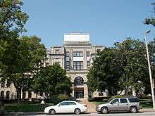 Rock Island County Courthouse | |
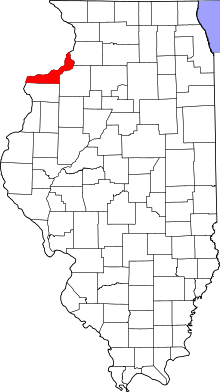 Location in the U.S. state of Illinois | |
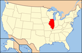 Illinois's location in the U.S. | |
| Founded | 1831 |
| Seat | Rock Island |
| Largest city | Moline |
| Area | |
| • Total | 451 sq mi (1,168 km2) |
| • Land | 428 sq mi (1,109 km2) |
| • Water | 24 sq mi (62 km2), 5.2% |
| Population | |
| • (2010) | 147,546 |
| • Density | 345/sq mi (133/km²) |
| Congressional district | 17th |
| Time zone | Central: UTC-6/-5 |
| Website |
www |
Rock Island County is a county located in the U.S. state of Illinois, bounded on the west by the Mississippi River. According to the 2010 census, it had a population of 147,546.[1] Its county seat is Rock Island; its largest city is neighboring Moline.[2]
Rock Island County is one of the four counties that make up the Davenport-Moline-Rock Island, IA-IL Metropolitan Statistical Area.[3]
History
Rock Island County was formed in 1831 out of Jo Daviess County. It was named for Rock Island, an island in the Mississippi River now known as Arsenal Island.[4]
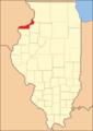 Rock Island County at the time of its creation in 1831
Geography
According to the U.S. Census Bureau, the county has a total area of 451 square miles (1,170 km2), of which 428 square miles (1,110 km2) is land and 24 square miles (62 km2) (5.2%) is water.[5]
Climate and weather
| Rock Island, Illinois | ||||||||||||||||||||||||||||||||||||||||||||||||||||||||||||
|---|---|---|---|---|---|---|---|---|---|---|---|---|---|---|---|---|---|---|---|---|---|---|---|---|---|---|---|---|---|---|---|---|---|---|---|---|---|---|---|---|---|---|---|---|---|---|---|---|---|---|---|---|---|---|---|---|---|---|---|---|
| Climate chart (explanation) | ||||||||||||||||||||||||||||||||||||||||||||||||||||||||||||
| ||||||||||||||||||||||||||||||||||||||||||||||||||||||||||||
| ||||||||||||||||||||||||||||||||||||||||||||||||||||||||||||
In recent years, average temperatures in the county seat of Rock Island have ranged from a low of 13 °F (−11 °C) in January to a high of 85 °F (29 °C) in July, although a record low of −22 °F (−30 °C) was recorded in February 1996 and a record high of 103 °F (39 °C) was recorded in July 2006. Average monthly precipitation ranged from 1.28 inches (33 mm) in January to 4.75 inches (121 mm) in June.[6]
Major highways
Adjacent counties
- Clinton County, Iowa (north)
- Whiteside County (northeast)
- Henry County (southeast)
- Mercer County (south)
- Louisa County, Iowa (southwest)
- Muscatine County, Iowa (west)
- Scott County, Iowa (northwest)
National protected area
Demographics
| Historical population | |||
|---|---|---|---|
| Census | Pop. | %± | |
| 1840 | 2,610 | — | |
| 1850 | 6,937 | 165.8% | |
| 1860 | 21,005 | 202.8% | |
| 1870 | 29,783 | 41.8% | |
| 1880 | 38,302 | 28.6% | |
| 1890 | 41,917 | 9.4% | |
| 1900 | 55,249 | 31.8% | |
| 1910 | 70,404 | 27.4% | |
| 1920 | 92,297 | 31.1% | |
| 1930 | 98,191 | 6.4% | |
| 1940 | 113,323 | 15.4% | |
| 1950 | 133,558 | 17.9% | |
| 1960 | 150,991 | 13.1% | |
| 1970 | 166,734 | 10.4% | |
| 1980 | 165,968 | −0.5% | |
| 1990 | 148,723 | −10.4% | |
| 2000 | 149,374 | 0.4% | |
| 2010 | 147,546 | −1.2% | |
| Est. 2015 | 146,133 | [7] | −1.0% |
| U.S. Decennial Census[8] 1790-1960[9] 1900-1990[10] 1990-2000[11] 2010-2013[1] | |||
As of the 2010 United States Census, there were 147,546 people, 61,303 households, and 38,384 families residing in the county.[12] The population density was 345.0 inhabitants per square mile (133.2/km2). There were 65,756 housing units at an average density of 153.8 per square mile (59.4/km2).[5] The racial makeup of the county was 81.6% white, 9.0% black or African American, 1.6% Asian, 0.3% American Indian, 4.4% from other races, and 3.0% from two or more races. Those of Hispanic or Latino origin made up 11.6% of the population.[12] In terms of ancestry, 25.9% were German, 14.2% were Irish, 8.7% were English, 6.8% were Swedish, and 5.2% were American.[13]
Of the 61,303 households, 29.0% had children under the age of 18 living with them, 45.3% were married couples living together, 12.7% had a female householder with no husband present, 37.4% were non-families, and 31.6% of all households were made up of individuals. The average household size was 2.34 and the average family size was 2.93. The median age was 40.0 years.[12]
The median income for a household in the county was $46,226 and the median income for a family was $58,962. Males had a median income of $42,548 versus $31,917 for females. The per capita income for the county was $25,071. About 8.7% of families and 12.3% of the population were below the poverty line, including 19.0% of those under age 18 and 7.1% of those age 65 or over.[14]
Economy
At one time Mississippi Valley Airlines had its headquarters in Quad City Airport in the county.[15] John Deere is headquartered in Moline.
Communities
Cities
Villages
Census-designated places
Unincorporated communities
- Buffalo Prairie
- Campbell's Island
- Castle Junction
- Edgington
- Ginger Hill
- Illinois City
- Joslin
- Taylor Ridge
Townships
Rock Island County is divided into eighteen townships:
See also
- National Register of Historic Places listings in Rock Island County, Illinois
- Quad City International Airport
Footnotes
- 1 2 "State & County QuickFacts". United States Census Bureau. Retrieved July 8, 2014.
- ↑ "Find a County". National Association of Counties. Retrieved June 7, 2011.
- ↑ United States Office of Management and Budget. "Update of Statistical Area Definitions and Guidance on Their Uses" (PDF). pp. 5, 36. Archived from the original (PDF) on May 14, 2006. Retrieved July 21, 2006.
- ↑ Rock Island, the island, History: Introduction, US Army Corps of Engineers
- 1 2 "Population, Housing Units, Area, and Density: 2010 - County". United States Census Bureau. Retrieved July 12, 2015.
- 1 2 "Monthly Averages for Rock Island, Illinois". The Weather Channel. Retrieved January 27, 2011.
- ↑ "County Totals Dataset: Population, Population Change and Estimated Components of Population Change: April 1, 2010 to July 1, 2015". Retrieved July 2, 2016.
- ↑ "U.S. Decennial Census". United States Census Bureau. Retrieved July 8, 2014.
- ↑ "Historical Census Browser". University of Virginia Library. Retrieved July 8, 2014.
- ↑ "Population of Counties by Decennial Census: 1900 to 1990". United States Census Bureau. Retrieved July 8, 2014.
- ↑ "Census 2000 PHC-T-4. Ranking Tables for Counties: 1990 and 2000" (PDF). United States Census Bureau. Retrieved July 8, 2014.
- 1 2 3 "DP-1 Profile of General Population and Housing Characteristics: 2010 Demographic Profile Data". United States Census Bureau. Retrieved July 12, 2015.
- ↑ "DP02 SELECTED SOCIAL CHARACTERISTICS IN THE UNITED STATES – 2006-2010 American Community Survey 5-Year Estimates". United States Census Bureau. Retrieved July 12, 2015.
- ↑ "DP03 SELECTED ECONOMIC CHARACTERISTICS – 2006-2010 American Community Survey 5-Year Estimates". United States Census Bureau. Retrieved July 12, 2015.
- ↑ "World Airline Directory." Flight International. March 30, 1985. 98. "Head Office: PO Box 949, Quad City Airport, Moline, Illinois 61265, USA."
Further reading
- Portrait and Biographical Album of Rock Island County, Illinois: Containing Full-Page Portraits and Biographical Sketches of Prominent and Representative Citizens of the County, Together with Portraits and Biographies of All the Governors of Illinois, and of the Presidents of the United States; Also Containing a History of the County, from its Earliest Settlement to the Present Time. Chicago: Biographical Publishing Co., 1885.
External links
 |
Scott County, Iowa | Clinton County, Iowa | Whiteside County | |
| Muscatine County, Iowa | |
|||
| ||||
| | ||||
| Louisa County, Iowa | Mercer County | Henry County |
Municipalities and communities of Rock Island County, Illinois, United States | ||
|---|---|---|
| Cities | ||
| Villages | ||
| Townships | ||
| CDPs | ||
| Other unincorporated communities |
| |
| Footnotes | ‡This populated place also has portions in an adjacent county or counties | |
Coordinates: 41°28′N 90°34′W / 41.47°N 90.57°W