Rondeslottet
| Rondslottet | |
|---|---|
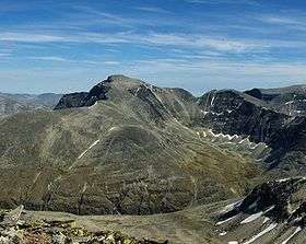 Rondslottet seen from Veslesmeden | |
| Highest point | |
| Elevation | 2,178 m (7,146 ft) |
| Prominence | 1,232 m (4,042 ft) [1] |
| Isolation | 53.6 kilometres (33.3 mi) |
| Listing | 3 at List of highest points of Norwegian counties |
| Coordinates | 61°54′59″N 9°51′10″E / 61.91639°N 9.85278°ECoordinates: 61°54′59″N 9°51′10″E / 61.91639°N 9.85278°E |
| Geography | |
| Location | Dovre and Folldal, Oppland and Hedmark, Norway |
| Parent range | Rondane |
| Topo map | 1718 I Rondane |
Rondslottet is the highest mountain in the Rondane mountain range and is also the highest mountain in the county Hedmark.
The name
For the first element, see Rondane. The last element is the finite form of slott 'palace'.
See also
References
Guidebooks
- A. Dyer et al. "Walks and Scrambles in Norway", ISBN 1-904466-25-7.
- Bernhard Pollmann "Norway South", ISBN 3-7633-4807-7.
This article is issued from Wikipedia - version of the 12/9/2013. The text is available under the Creative Commons Attribution/Share Alike but additional terms may apply for the media files.