Rose Woods
| Rose Woods | |
| (Wible's Woods during the commemorative era) | |
| Woods | |
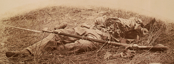 Soldier killed by artillery fire on the southwestern edge of the Rose Woods, near the Wheatfield.[1] | |
| Name origin: "J. Rose"[2] | |
| Country | United States |
|---|---|
| State | Pennsylvania |
| County | Adams |
| NPS unit | Gettysburg National Military Park |
| Tract | Rose Farm, Pennsylvania |
| Biome | Northern Piedmont ecoregion |
| Geology | Gettysburg-Newark Lowlands, Rossville Diabase dike[3] (50 feet thick) |
Rose Woods is a Gettysburg Battlefield forested area that is an American Civil War site of the battle's Hood's Assault, McLaws' Assault, and McCandless' Advance. "Scene of the first line of Union defenses"[4] on the Battle of Gettysburg, Second Day; the 1st Texas Infantry and 3rd Arkansas Infantry Regiments attacked Ward's 2nd Brigade line in the woods. The last combat on the Battle of Gettysburg, Third Day, was "in the early evening. Colonel William McCandless's brigade of Pennsylvania Reserves advanced across the Wheatfield into Rose's Woods where they managed to inflict heavy losses on the 15th Georgia" which had failed to retreat to Warfield Ridge after Longstreet's Assault.[5] Two days later Timothy H. O'Sullivan photographed corpses moved for burial to the edge of Rose Woods[6] and which were subsequently reinterred in cemeteries.
De Trobriand Avenue and other Military Park roads provide access to the woods' battlefield monuments, and the woods' railbed for the 1894-1916 Gettysburg Electric Railway is a historic district contributing structure that is now a rail trail. Monuments in the woods include the 1890 Sixty-fourth New York Regiment Monument, and Wheat-field Park[7] in "Wible's Grove" was a commemorative era trolley park.[8] The trolley's overhead power line broke at Wible's Woods in 1900,[9] and the woods had the postbellum "William Wible's Quarry"[10] for Gettysburg Granite (cf. Rosensteel's Quarry north of the Round Top Museum).[11] In 2004, the archeological remains of the former trolley bridge in Rose Woods were named a historic district contributing structure.[12]
References
- ↑ Frassanito's Early Photography at Gettysburg, p. 336 identifies the photograph as "Dead Confederate soldier in the field at the southwestern edge of the Rose Woods." (The Library of Congress identifies the photo site as The Wheatfield).
- ↑ …Battle Field of Gettysburg (Map). Cartography by Gettysburg Park Commission (Nicholson, John P; Cope, Emmor; Hammond, Schuyler A). New York: Julius Bien & Co. Lith. 1904. Check date values in:
|access-date=(help); - ↑ "Gettysburg National Military Park and Eisenhower National Historic Site: Geologic Resources Inventory Report" (PDF). Denver, Colorado: National Park Service: Natural Resource Program Center. 2009. Retrieved 2010-02-02.
- ↑ Davis, W. G. "About what you are looking at…" (image description). Behind The Stonewall. JaTruck.com. Retrieved 2012-05-06.
- ↑ http://www.nps.gov/history/history/online_books/gett/gettysburg_seminars/12/third_day.htm
- ↑ http://www.loc.gov/pictures/resource/cwpb.00865/
- ↑ "Hoffer Sells Out" (Google News Archive). The Star and Sentinel. January 22, 1895. Retrieved 2011-02-24.
Agreements with William Wible for the use of the Wheat-field Park, containing 25 acres, at the rate of $5 per day for each excursion to said park by the said Railway Company.
- ↑ 1893: https://news.google.com/newspapers?id=sqslAAAAIBAJ&sjid=XvwFAAAAIBAJ&pg=7010,628890&dq=wible's-woods&hl=en
1895: https://news.google.com/newspapers?id=1P0yAAAAIBAJ&sjid=jAAGAAAAIBAJ&pg=1457%2C6999057
1903: https://news.google.com/newspapers?id=opQzAAAAIBAJ&sjid=HOkFAAAAIBAJ&pg=4724,2881399&dq=wible's+grove&hl=en - ↑ https://news.google.com/newspapers?id=UhUbAAAAIBAJ&sjid=y0gEAAAAIBAJ&pg=1001,4361799&dq=tipton+trolley+gettysburg&hl=en
- ↑ http://www.gettysburgdaily.com/?p=1836
- ↑ https://news.google.com/newspapers?id=OwYmAAAAIBAJ&sjid=__wFAAAAIBAJ&pg=5369,778722&dq=entrance-station+gettysburg&hl=en
- ↑ "Electric Trolley Bed". Retrieved 2011-03-02.
[rail] trail along Plum Run at Devil's Den, runs N through Rose Farm & stops near The Loop. … Pair of cut stone block abutments over Rose Run, 5' high, 25' long & approx 10' apart.