Roseto Capo Spulico
| Roseto Capo Spulico | |
|---|---|
| Comune | |
| Comune di Roseto Capo Spulico | |
|
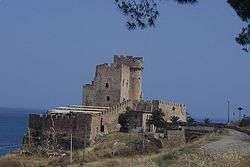
View of the Castrum Petrae Roseti in Marina di Roseto Capo Spulico | |
 Roseto Capo Spulico Location of Roseto Capo Spulico in Italy | |
| Coordinates: 39°59′N 16°36′E / 39.983°N 16.600°E | |
| Country | Italy |
| Region | Calabria |
| Province / Metropolitan city | Cosenza (CS) |
| Frazioni | Centro,Borgata Marina,Villaggio Baiabella |
| Government | |
| • Mayor | Rosanna Mazzia |
| Area | |
| • Total | 30 km2 (10 sq mi) |
| Elevation | 217 m (712 ft) |
| Population (31 August 2011) | |
| • Total | 1,914 |
| • Density | 64/km2 (170/sq mi) |
| Demonym(s) | Rosetani |
| Time zone | CET (UTC+1) |
| • Summer (DST) | CEST (UTC+2) |
| Postal code | 87070 |
| Dialing code | 0981 |
| Website | Official website |
Roseto Capo Spulico is a town and comune of the province of Cosenza in the Calabria region of southern Italy. Roseto was originally one of the satellite cities of Sybaris, at the time of Magna Grecia; it is the coastal areas of Southern Italy on the Tarentine Gulf that were extensively populated by Greek settlers.
Roseto Capo Spulico was named after the roses that were cultivated there.
The petals were used to fill the mattresses on which the sybaritic slept. The Rose Garden today was born in the tenth century AD and reached its peak in 1260 when the Castrum Petrae Roseti (castle of Roseto) was built. It is also known for The Church of the Immaculate Conception, built in the 15th century, a rustic, masonry church that sits on the edge of a cliff.
As a tourist destination, Roseto is known for its beaches and seaside resorts.[1][2]
References
- ↑ "Cosa vedere". La Dimora Bed And Breakfast. Retrieved December 2, 2014.
- ↑ "Storia - Comune di Roseto Capo Spulico". rosetocapospulico.cs.it. Retrieved December 2, 2014.
External links
| Wikimedia Commons has media related to Roseto Capo Spulico. |