Rotch Dome

Location of Livingston Island in the South Shetland Islands.
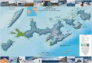
Topographic map of Livingston Island, Greenwich, Robert, Snow and Smith Islands.
Rotch Dome is the sloping ice dome rising to 360 m immediately east of Byers Peninsula, and between Barclay Bay and Walker Bay in Livingston Island, South Shetland Islands, Antarctica. Bounded by Urvich Wall to the west, surmounting Etar Snowfield to the northeast and Verila Glacier to the east-northeast, and linked by a saddle to Casanovas Peak to the northeast.
Location
The highest point is located at 62°38′00″S 60°52′59″W / 62.63333°S 60.88306°W which is 10.4 km southwest of Casanovas Peak, 6.75 km north by west of Elephant Point, 6.1 km east of Tsamblak Hill and 4.77 km south by east of Rowe Point (British mapping in 1968, Bulgarian in 2005 and 2009).
Maps
- L.L. Ivanov et al. Antarctica: Livingston Island and Greenwich Island, South Shetland Islands. Scale 1:100000 topographic map. Sofia: Antarctic Place-names Commission of Bulgaria, 2005.
- L.L. Ivanov. Antarctica: Livingston Island and Greenwich, Robert, Snow and Smith Islands. Scale 1:120000 topographic map. Troyan: Manfred Wörner Foundation, 2009. ISBN 978-954-92032-6-4
References
This article is issued from Wikipedia - version of the 11/21/2015. The text is available under the Creative Commons Attribution/Share Alike but additional terms may apply for the media files.