Rouchleau Mine
_a.jpg)
The Rouchleau Mine is an abandoned open-pit mine within the Mesabi Iron Range at Virginia, Minnesota, United States. The mine, located on the east side of the city, is roughly 3 miles (4.8 km) long and .5 miles (0.80 km) wide; its deepest point is 450 feet (140 m) below its surface, making it one of the deepest mines in the range.[1] Named for Louis Rouchleau, who explored the area for its mining potential, the mine was initially created as a shaft mine. It was converted to a pit mine by the 1930s due to improvements in open-pit mining technology and increasingly unstable terrain which made shaft mining unsafe.[2]
Ten companies have overseen mining operations at the Rouchleau Mine since it began operating in 1893.[1] The majority owner has always been either present owner U.S. Steel or one of the firm's predecessors. The mine has produced 300 million gross tons of iron ore since it opened; it was last mined in 1977.[2]
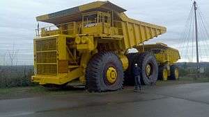
Since its closure, the mine became part of Mineview in the Sky, a local tourist attraction. Mineview in the Sky featured a viewing platform overlooking both the Rouchleau Mine and an active United Taconite mine; it also included a 240-ton mining truck, a production truck, a railroad car, and a visitor center.[1] The attraction closed in 2015 due to United Taconite's planned expansion into the land it occupied.[3] The mine expansion will also force U.S. Route 53 to relocate by 2017; the Minnesota Department of Transportation is planning to build a bridge over the Rouchleau Mine to carry the highway.[4]
See also
References
- 1 2 3 "Mineview in the Sky". Iron Trail Convention & Visitors Bureau. Retrieved December 19, 2015.
- 1 2 Green, Doris (2003). Minnesota Underground & the Best of the Black Hills: A Guide to Mines, Sinks, Caves, and Disappearing Streams. Big Earth Publishing. p. 103. ISBN 9781931599245.
- ↑ Kraker, Dan (October 3, 2015). "Mineview in the Sky, an Iron Range tourist attraction, to close Sunday". Minnesota Public Radio. Retrieved December 19, 2015.
- ↑ Hanna, Bill (November 18, 2014). "Bridge over Rouchleau Pit". Mesabi Daily News. Retrieved December 19, 2015.
Coordinates: 47°30′42″N 92°31′20″W / 47.5115931°N 92.5221273°W