Rouissat
| Rouissat اﻟﺮوﻳﺴﺎت | |
|---|---|
| Town | |
 Rouissat | |
| Coordinates: DZ 31°55′N 5°21′E / 31.917°N 5.350°E | |
| Country |
|
| Province | Ouargla Province |
| District | Ouargla District |
| Elevation | 138 m (453 ft) |
| Population (2008)[1] | |
| • Total | 58,112 |
| Time zone | CET (UTC+1) |
Rouissat is a town and commune in Ouargla District, Ouargla Province, Algeria. According to the 2008 census it has a population of 58,112,[1] up from 37,814 in 1998,[2] and a population growth rate of 4.5%.[1] It is within the urban area of the provincial capital Ouargla, lying just to the south of the city center.
Localities
The commune is composed of eight localities:[3]
- Rouissat
- El Hadeb
- Babanou
- Sidi Naïmi
- Ziaïna
- Sidi Bansaci
- Sokra
- Berkaoui
References
- 1 2 3 "Population: Béchar Wilaya" (PDF) (in French). Office National des Statistiques Algérie. Retrieved 24 February 2013.
- ↑ "Algeria Communes". Statoids. Retrieved 8 March 2013.
- ↑ "Décret n° 84-365, fixant la composition, la consistance et les limites territoriale des communes. Wilaya d'El Oued" (PDF) (in French). Journal officiel de la République Algérienne,. 19 December 1984. p. 1551. Archived from the original (PDF) on 2 March 2013 or before. Retrieved 2 March 2013. Check date values in:
|archive-date=(help)
Neighbouring towns and cities
 |
N'Goussa Ouargla |
Touggourt Ain Beida Sidi Khouiled Hassi Ben Abdellah |
| |
| Ghardaia | |
Hassi Messaoud | ||
| ||||
| | ||||
Capital: Ouargla | ||
| Ouargla District | 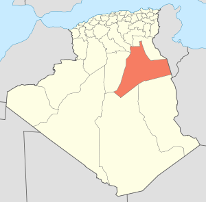 | |
| El Borma District | ||
| El Hadjira District | ||
| Hassi Messaoud District | ||
| Mégarine District | ||
| N'Goussa District | ||
| Sidi Khouïled District | ||
| Taïbet District | ||
| Témacine District | ||
| Touggourt District | ||
Coordinates: 31°55′N 5°21′E / 31.917°N 5.350°E
This article is issued from Wikipedia - version of the 5/28/2015. The text is available under the Creative Commons Attribution/Share Alike but additional terms may apply for the media files.