Rourkela
| Rourkela ରାଉରକେଲା | |
|---|---|
| Metropolitan City | |
|
Anticlockwise from top left: Hanuman Vatika, National Institute of Technology, Rourkela, Rourkela Steel Plant, Bhanja Bhawan and Entrance Highway to Rourkela Main City. | |
| Nickname(s): Steel City, Ispat Nagar, Industrial Capital of Odisha, Mini India | |
 Rourkela  Rourkela Location in Odisha, India | |
| Coordinates: 22°14′57″N 84°52′58″E / 22.24917°N 84.88278°ECoordinates: 22°14′57″N 84°52′58″E / 22.24917°N 84.88278°E | |
| Country |
|
| State | Odisha |
| District | Sundergarh |
| Established | 1954 |
| Government | |
| • Type | Mayor-Council |
| • Body | Rourkela Municipal Corporation (RMC) |
| Population | |
| • Rank | 80th (India) & 3rd (Odisha) |
| • Density | 6,696/km2 (17,340/sq mi) |
| • Metro | 536,450[1][2] |
| Languages | |
| • Official | Odia |
| Time zone | IST (UTC+5:30) |
| PIN | 769001-769xxx |
| Telephone_code | 0661 |
| Vehicle registration | OD-14 (OR-14 before 2012) |
Rourkela ![]() pronunciation (Odia: ରାଉରକେଲା) is a city located in the northern border of the Indian state of Odisha, also known as Orissa. It is Third largest city of Odisha. It is situated about 340 kilometres (211 mi) north of state capital Bhubaneswar, and is surrounded by a range of hills and encircled by rivers. The city is also popularly known as Ispat Nagar and also as the Steel City of Odisha. It has one of the largest steel plants of the Steel Authority of India Limited (SAIL) known as Rourkela Steel Plant. It also has one of the National Institutes of Technology (NIT Rourkela) of the country. The city has been selected as smart city in the third phase of smart city list on 20-sep 2016. Among all the 27 city list rourkela ranked 12th position on merit basic.
pronunciation (Odia: ରାଉରକେଲା) is a city located in the northern border of the Indian state of Odisha, also known as Orissa. It is Third largest city of Odisha. It is situated about 340 kilometres (211 mi) north of state capital Bhubaneswar, and is surrounded by a range of hills and encircled by rivers. The city is also popularly known as Ispat Nagar and also as the Steel City of Odisha. It has one of the largest steel plants of the Steel Authority of India Limited (SAIL) known as Rourkela Steel Plant. It also has one of the National Institutes of Technology (NIT Rourkela) of the country. The city has been selected as smart city in the third phase of smart city list on 20-sep 2016. Among all the 27 city list rourkela ranked 12th position on merit basic.
Name
The name Rour-kela originates from the local tribal language of Sadri which means "Your Home". It comes under Sundergarh district of the Indian state of Odisha. An indigenous community called Rautia used to inhabit this region.[3]
History
The twin towns of Rourkela and Fertilizer Township as well as their developed periphery are located in areas that were once covered by dense forests. These forests were once favourite hunting ground for the kings in the past. According to the census report of 2011 Rourkela has a population of 483,038(Rourkela Industrial Township is 273,217 and Rourkela Town is 210,412) and the urban metropolitan area population is 536,450.[1][2] Then railway station of Rourkela was within the revenue village of Mahulpali. India's first public sector steel plant facility was established in Rourkela with the help of German businesses Krupp & Demag. In the late 1950s and early 1960s, the town was the largest German colony outside Germany. Some merchants, started settling at Rourkela with business objective, around the village Rourkela and the Railway station was named after the village Rourkela. The erstwhile revenue village of Rourkela is now popularly known as old Rourkela. The B.N.R. Company (Bengal-Nagpur Railway Company) constructed the Howrah Nagpur railways, which ran through Rourkela. The habituated area around the railway station of Rourkela was declared as an urban town in the year 1931. The census report of 1931 reveals that the number of population was 493. By the time a primary school, an office of the forester, a sub-post office, a handful of liquor shops, tea shops and restaurants were found around the outlying area of the railway station. Gradually a train line was connected to Birmitrapur and Rourkela and it could avail a status of a junction allowing the settlement of more railway employees. Soon another station at the village Panposh was found 10 Kilometres away. The population of Panposh by 1931 was 2,252 almost five times of Rourkela. There was a village called Durgapur in between Rourkela and Panposh stations. The construction of the sub-divisional court building was started in 1945 at the village Durgapur (Hence the nearby Hills also known as Durgapur Pahada(Durgapur Hills), today it is known as Uditnagar. As a result, the two railway stations of Panposh and Rourkela came into recognisation. Following India's independence, Pundit Jawaharlal Nehru, the first Prime Minister of India, wanted to make India an industrialised state in Soviet model of social development; giving wings to his dreams Sri Biju Pattanaik convinced Pandit Nehru to consider the location of Rourkela for setting up a steel plant. The mineral rich zone of Rourkela intersected by the rivers Brahmani, Koel and Sankha from two sides was aptly chosen for the same. The preliminary survey for the steel plant at Rourkela was started in 1952 and the Government of Odisha issued a gazette notification on 16th February 1954. In accordance with the notification the Government of Odisha acquired an area of about 80 square miles around Rourkela for the purpose of Steel Plant. The private German private companies Krupp and Demag came forward to provide financial and technical help for the proposed steel plant at Rourkela. Krupp built Rourkela Steel Plant drawing from experience from its own works in Essen, Germany. The technical experts of the company advised the Government of India as well as the Government of Orissa for acquiring more land. As a result a further area of 32 square kilometres was acquired out of 31 revenue villages. Almost 13,000 people in 2,424 families lost their dwelling. Later further 11,000 acres of land were acquired out of 31 revenue villages for the construction of Mandira Dam, a water embankment. More land was requisited for the purpose of constructing railway lines to Hatia and Barsuan. The construction of Bondamunda Railway junction required further acquisition of land which resulted 20,000 people's displacement from their habitat. Though there was initial discontentment among the tribals about the land acquisition the authority largely resolved the land dispute, as many of the tribals were provided employment and accommodation. The displaced tribals were relocated in places such as Jalda, Jhirpani and Bondamunda. Their new settlement even extended beyond the river Koel. A string of industrial units and townships such as Rourkela Steel Plant, Fertilizer Plant, Fertilizer Township, Steel Township sprung up. A marshalling yard and a railway junction were established at Bondamunda. Thousands of technical personnel from West Germany came to Rourkela to extend their technical assistance. Some of these Germans came with their family and their small diaspora created 'Indo-German Club' to socialise. The club exists today with a well-stocked library known as Max Muller library. There are plethora of local stories of Germans social encounters with tribals (local adivasis) and people from other parts of India who had relocated themselves to Rourkela for employment. A large part of this population was from coastal and western Odisha who were trained by the German workforce to adopt to the steel plant's technology rigour. The steel plant, which was hugely surrounded by forest, many times witnessed wild animals straying into the plant area. A royal bengal tiger's lugubrious death in the steel plant's massive blast furnace is a part of city's follklore. There were also tales about the disappearance of Germans in the nearby Vedvyas cave and dread whirlpool of river Koel. A popular gynaecologist Dr DP Dey of Rourkela's largest hospital was one of the unfortunate victims of this surreptious whirlpool. The river still accounts for human casualty as some day trippers wade into the water blissfully unasware of the maelstrom. Of late, Rourkela has seen many modernisation as well as infrastructural developments. Recently, the Railway ministry announced the operations of a new Rajdhani train that would go via Rourkela.
Geography

Rourkela is located at 84.54E longitude and 22.12N latitude in Sundergarh district of Odisha at an elevation of about 219 meters above mean sea level. The area of Rourkela is 200 square kilometres approximately. Being situated on Howrah-Mumbai rail track, Rourkela had an added advantage of the steel plant being set up there. Red and laterite soils are found here which are quite rich in minerals. The area near Rourkela is rich in iron-ore hence a steel plant is situated in Rourkela. Bolani and Barsuan are the two most prominent mines situated near the town. Rourkela is situated in a hilly region. A small hill range named Durgapur runs from the heart of the town dividing it into plant area and the steel township. The name "Durgapur" comes from an old village existed at the foothills long time ago before the plant was set up. The Koel and Sankha rivers meet at Vedvyas, Rourkela and flow as a single river called Brahmani.
Layout
The Rourkela Township is divided into two separate townships under Census of India as Steel Township and Civil Township. The Residential quarters colony of Rourkela Steel Plant having 21 sectors on record (while in reality the Sector – 10, 11 and 12 do not exist, though the area for the same is earmarked) is called Steel Township and the other part is called Civil Township. One smaller township Fertilizer was renamed sector-22, as this township is within the purview of SAIL.[4]
The 16 kilometers long Ring Road,[5] connects 19 sectors and some other parts of the steel city including old Rourkela. Other layouts include Civil Township, Station Road (Bus & Railway), Koel Nagar, Jagda, Jhirpani, Panposh, Udit Nagar, Fertiliser Township, Hamirpur, IGH Road, Vedvyas.
Climate
Rourkela has a tropical climate and receives high rainfall during Southwest monsoon (June – September) and retreating Northeast monsoon (December – January). Average annual rainfall ranges between 160 and 200 cm. The minimum and maximum temperatures are in the range of 5 C to 47 C with a mean minimum and maximum temperature range of 9.8 C to 39.2 C during coldest and hottest months. Thirty six percent of the geographical area of the district has semi-evergreen or tropical dry deciduous forest.[6]
| Climate data for Rourkela, Odisha | |||||||||||||
|---|---|---|---|---|---|---|---|---|---|---|---|---|---|
| Month | Jan | Feb | Mar | Apr | May | Jun | Jul | Aug | Sep | Oct | Nov | Dec | Year |
| Average high °C (°F) | 27.0 (80.6) |
29.6 (85.3) |
34.9 (94.8) |
42.3 (108.1) |
49.0 (120.2) |
37.2 (99) |
31.3 (88.3) |
31.1 (88) |
31.5 (88.7) |
31.1 (88) |
28.6 (83.5) |
26.8 (80.2) |
33.37 (92.06) |
| Average low °C (°F) | 12.1 (53.8) |
14.4 (57.9) |
18.9 (66) |
23.7 (74.7) |
27.0 (80.6) |
26.8 (80.2) |
25.0 (77) |
24.9 (76.8) |
24.6 (76.3) |
21.5 (70.7) |
15.4 (59.7) |
11.8 (53.2) |
20.51 (68.91) |
| Average rainfall mm (inches) | 13 (0.51) |
20 (0.79) |
19 (0.75) |
15 (0.59) |
40 (1.57) |
221 (8.7) |
416 (16.38) |
419 (16.5) |
218 (8.58) |
56 (2.2) |
8 (0.31) |
3 (0.12) |
1,448 (57) |
| Source: en.climate-data.org | |||||||||||||
Economy
Rourkela is the industrial capital of Odisha. It has industries of all sizes. The city is known internationally for iron & steel trades. Recent upspurt in iron & steel pricing has seen a lot of industries of all sizes coming in and around Rourkela. The city is near the source of raw materials.
Civic administration
The steel city is divided mainly into two sections: Old Rourkela (sections of the city near the railway station that were settled prior to RSP coming up) and the much larger Steel township. The Steel township till 1999, was divided into 18 Sectors, Sector 6 being the largest of them.
The Steel Township and Fertilizer Township are under the Steel Plant Administration while the other sections of the city are under the Rourkela Municipal Corporation. Some rural areas of South Rourkela are managed by the Jalda Panchayat. Central Water Commission has its sub divisional headquarter near Panposh.
Demographics
As of 2011 India census,[7][8] Rourkela had a population of 536,450. Males constitute 54% of the population and females 46%. Rourkela has an average literacy rate of 75%, higher than the national average of 59.5%: male literacy is 81%, and female literacy is 69%. In Rourkela, 12% of the population is under 6 years of age.
- Density of Population – 6,696 per km2. approx.
- Sex Ratio – 835 Female per 1000 male.
- Per capita income – Highest in Odisha.
- Population (Census 2011) – 552,970 where as Rourkela Industrial Township (210,412) & Rourkela Town (273,217).
- Main Habitations in Rourkela – Civil Township, Koelnagar, Chhend Colony, Uditnagar, Steel Township (Eighteen Sectors), Fertilizer Township, Industrial Estate, Basanti colony, Railway colony, Jhirpani, Jagda, Panposh, Vedavyas, Bondamunda and Kalunga.
Transport
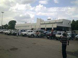
It has a developed transportation network. Rourkela railway station is on the Tatanagar–Bilaspur section of Howrah-Nagpur-Mumbai line under Chakradharpur rail division in the South Eastern Railway Zone headquartered at Kolkata. Rourkela city is connected with NH 143(former NH-23),it connect with AH46 at Barkote and SH-10 to the towns and cities of Odisha. Independent three-wheeler auto taxis without meters and local self governance are the most important mode of transportation in the city. Sampark buses, introduced in September 2006, connect various areas in the city. At one time Rourkela was the only city in Odisha to have a direct air connectivity with Kolkata. Around 2010–11, the authority of Rourkela Airport was passed over to Airport Authority of India. DTDS, Sky Airways and Air Odisha were connecting Rourkela with other parts of Odisha. According to the 12th fifth year plan of the Central Government, Rourkela airport would be converted into a mini airport. Also the new Biju Expressway will connect this city with Jagdalpur (Chhatisgarh).
Recreation
Rourkela has three recreation parks: Indira Gandhi Park, Jubilee Park, and Ispat Nehru Park Udyaan.
Bhanja Bhaban (comprising the Bhanja Kala Kendra and the library) and Civic Centre hosts the State level and National Level Drama, Fashion and Dancing competitions throughout the year.
The city has several cinemas, namely Konark and UMA, the two most popular ones. Apsara, Deepak & Razzaq (presently all of them being turned into multiplex). A couple of multiplexes however have started recently, namely PSR Cinemas and Cineplex @ Shanti Towers. Several food courts like Ambagan food court, Sec-5 VIP market, Koel Nagar NAC market, Khana Khazana, 7 AM & Max Restaurant & Bakery in New Rourkela, Green Chillyz behind Ambagan are some of the most visited places.
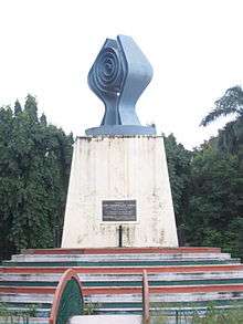
"The Hands of Steel" or the "Ten Million Monument" was designed by Vijay Acquilla and made at the initiative of Dr. P L Agarwal.
Media
Rourkela City has a radio station of All India Radio (A.I.R) on FM Band 102.06 MHz since 24 June 1995. AIR Rourkela has two transmission one from 12pm to 5pm & the second from 6pm to 11pm. Other privately owned radio channels include Radio Choklate 104 FM and Big 92.7 FM. These channels broadcast Hindi & Oriya film and non film songs, talk shows and other entertainment programmes.
The Oriya daily newspaper Sambaad gets published in its Rourkela section press.
Education
Rourkela is the educational, technical and medical research hub of Western Odisha and even students from all parts of Odisha and some parts of neighbouring states Jharkhand and West Bengal come here to pursue higher education. It houses many English medium schools which provide CBSE and ICSE certificates to their students. Notably, mostly there are ICSE-ISC board schools like St.Gregorios Higher Secondary School,Ispat EM School, St. Paul's School, Mount Carmel School, Pragati Public School, Sectorn 22, St. Joseph's School, Indo English School, Chinmaya Vidyalaya(E.M.), Desouza's School, MGM English Medium School. Most of them are missionary based organisations run by licensee trustees. The CBSE board schools are Deepika English Medium School, Delhi Public School, Dayanand Anglo-Vedic (DAV) School, etc. The Central government has its own Kendriya Vidyalaya in Sector 6 and Bondamunda. It also has notable Odiya medium schools like Chinmaya Vidyalaya and Govt High school Uditnagar.
The National Institute of Technology, Rourkela (NIT-R) ranks 5th in terms of education and placement quality in India. The students of various schools in Rourkela represent their schools in various national level and international competitions including IMO, IChO and NASA.[9][10][11]
Rourkela has a Hi-Tech Medical College and Hospital Rourkela and is the only city in Odisha to have a private medical college outside Bhubaneshwar. The local leaders have demanded a government medical college in Rourkela. There are over 15 colleges for arts, science and commerce streams under the Sambalpur University. Some of the famous ones are Government Autonomous College, Rourkela Municipal College, Ispat College, SG Women's College. There are also private engineering & management colleges like Rourkela Institute of Management Studies (RIMS), DAMITS, Rourkela Institute of Technology (RIT), Padmanava College of Engineering (PCE). These colleges come under the jurisdiction of Biju Patnaik University of Technology (BPUT) and the head office is located in Chennd, Rourkela.[12]
Universities
Sports
Hockey
Indian captain Dilip Tirkey and deep defender Lazarus Barla started their careers in Rourkela. Rourkela has special hockey hostels for kids, upbringing the next generation players with some of the best amenities. It has produced a few Arjuna Awardees, including Minati Mohapatra. Olympians of repute like Paralympian Roshan and Rachita Mistry are from this city. Indian national cricketer Sanjay Raul and the Under-19 world cup representative Chandrakant Barik play from this city. Pabitra Mohan Mohanty, the former national 'B' champion in chess and second only to Viswanathan Anand in national 'A' category is a resident of this city.
The city has a sports hub of two stadiums and few other sports grounds located in sector-6. The two stadiums are Ispat Stadium and a beautiful AstroTurf hockey stadium. The AstroTurf hockey stadium was built by SAIL. There is a basketball ground, a chess hall, and a well-maintained volleyball ground nearby. The indoor stadium at sector-20 hosts the badminton and Table Tennis events.
Stadiums
Rourkela has an International hockey stadium with synthetic astroturf which has been host to World Junior Hockey Championship and been a training centre to most of the international Hockey players of India. Ispat Stadium has been host for several Ranji Trophy matches. The city has produced many reputed Ranji players in the recent times.
- Sports Hostel, Chhend
- Ispat Stadium (Sector-6)
- Biju Patnaik Hockey Stadium (Sector-6)
- Sports Hostel, Panposh
- Ispat Mini Stadium, Fertiliser Township (Sector-22)
Notable residents
- Mira Nair, Film Director & Author
- Jual Oram, Union Minister for Tribal, BJP
- Dilip Tirkey, Former Captain, Indian National Hockey Team
- Ignace Tirkey, Former Captain, Indian National Hockey Team
- Lazarus Barla, Indian hockey player
- Natraj Behera, Odisha cricket team captain
- Harish Hande, Magsaysay Award winner
- Bibhu Mohapatra, Fashion Designer, United States of America
- Rajasmita Kar, Winner of Dance India Dance (Season 3), India
- Dilip Ray, MLA (Rourkela), Founder of Mayfair group of hotels
- Amish Tripathi, Author
- Rachita Panda Mistry, Olympiad
- Biswapati Sarkar, Media Personality of TVF fame
- Samir Dash, Techie and Entrepreneur
- Ramendra Kumar, Award winning Children's Fiction Writer
See also
References
- 1 2 "Census of India: Search Details". Retrieved 31 January 2016.
- 1 2 "Census of India: Search Details". Censusindia.gov.in. Retrieved 2016-01-31.
- ↑ Rourkela Reader, see "Rourkela from 1921 to 2005". (PDF) . Retrieved on 15 April 2012.
- ↑ About Rourkela and its History | Greater Rourkela | Rajgangpur | Kansbahal | Bonai of India. Rourkelacity.com. Retrieved on 15 April 2012.
- ↑ Polar Electro Oy (2015-07-07). "Session analysis - Polar Flow". Flow.polar.com. Retrieved 2016-01-31.
- ↑ Field Station- Rourkela (Odisha). National Institute of Malaria Research. mrcindia.org
- ↑ "Census of India: Search Details". Retrieved 31 January 2016.
- ↑ "Census of India: Search Details". Retrieved 31 January 2016.
- ↑ Rourkela Girl Topped in NASA Contest | Rourkela | Rajgangpur | Kansbahal | Bonai of India. Webcache.googleusercontent.com (5 May 2010). Retrieved on 15 April 2012.
- ↑ India to host Chemistry Olympiad | 33rd International Chemistry Olympiad. Hindu.com. Retrieved on 6 April 2013.
- ↑ Deepika English Medium School|deepika school rourkela. Deepikaemschool.org. Retrieved on 15 April 2012.
- ↑ bput.ac.in. bput.ac.in. Retrieved on 15 April 2012.
 |
Ambikapur | Simdega | Jamshedpur | |
| Bilaspur | |
Kharagpur | ||
| ||||
| | ||||
| Sambalpur | Talcher | Keonjhar |
| Governance |
|  |
|---|---|---|
| Topics | ||
| GI Products | ||
| Districts | ||
| Cities | ||