Route 46 Passaic River Bridge
The Route 46 Passaic River Bridge can refer to a number of bridges that carry U.S. Route 46 (US 46) over the Passaic River in Northern New Jersey. US 46 was originally developed as Route 6 under the direction of Morris Goodkind who was chief engineer of the New Jersey Highway Department (predecessor to the New Jersey Department of Transportation) from 1922 until 1955.
The highway is designated the United Spanish War Veterans Memorial Highway.[1] It crosses the river several times as both wind their way through Bergen, Passaic, Essex, and Morris counties. To the east the highway also crosses the Hackensack River on the Winant Avenue Bridge and the Hudson River (to the state line) on the George Washington Bridge. To the west the highway crosses several of the Passaic's tributaries.[2]
Route 6 (1927–1953) and Route 46 (1953–present)
.svg.png)
In the 1927 New Jersey state highway renumbering Route 6 was assigned to the route across northern New Jersey, using the old Route 5 from Delaware to Netcong, Route 12 from Hackettstown to Paterson, and a generally new alignment parallel to Route 10 from Paterson to the proposed George Washington Bridge. In Paterson, Route 6 was marked along city streets including McBride Avenue, Spruce Street and Market Street.[3][4]
In 1929, Route 6 was redefined to use none of the old road east of Paterson (it had formerly been planned to use Market Street west of roughly where Route 17 now crosses it), and Route 5 was cut back to run only east from Ridgefield.[5] Route 6 was redefined to bypass Paterson to the south. The new highway would enter Paterson just south of Market Street, but then turn south and southwest before heading west to rejoin the route at the Little Falls bypass at the Union Boulevard crossing. The old road along Union Boulevard towards Paterson was assigned Route S6, as a spur of Route 6.[5] Route S6 became Route 62 in the 1953 New Jersey state highway renumbering, and has since been truncated to a short distance between US 46 and I-80 in Totowa.[6] By 1937, most of Route 6 had been completed with the exception of the Paterson bypass.[7] A realignment at the Passaic River crossing near Pine Brook was built in the 1940s, along with a new road for a short distance west from Pine Brook.[8][9]
The Route 6 designation was dropped in favor of US 46 in the 1953 renumbering.[6]
The Passaic River Bridge at Paterson and Passaic River Bridge at Totowa are significant sophisticated examples of an open spandrel arch, reinforced concrete highway bridge and are representative of approximately ten of the type designed and built by the New Jersey State Highway Department between 1929 and 1939 as part the expansion of the state highway system west. In the 1990s, the New Jersey Department of Transportation (NJDOT) Historic Bridge Survey recommended the New Jersey State Historic Preservation Officer determine that they were eligible for inclusion on the state and federal registers of historic places[10][11]
Bridges
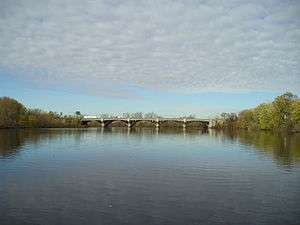

Gallery
-
Route 6 originally crossed Lackawanna Avenue just north of Route 46 Totowa bridge
-

At Paterson
See also
- List of crossings of the Upper Passaic River
- List of crossings of the Lower Passaic River
- List of crossings of the Hackensack River
- List of fixed crossing of the North River (Hudson River)
- List of bridges documented by the Historic American Engineering Record in New Jersey
References
- ↑ "New Jersey Department of Transportation Dedicated Highways and Bridges" (PDF). New Jersey State Library. October 25, 2012. Retrieved November 25, 2016.
- 1 2 3 4 5 6 New Jersey Department of Transportation (July 2014). "US 46 Straight Line Diagram" (PDF). New Jersey Department of Transportation. Retrieved November 21, 2016.
- ↑ State of New Jersey. Laws of 1927. Chapter 319.
- ↑ Unknown (n.d.). Sketch Map Showing Approximate Location of New Jersey State Highway Routes as Designated by Chapter 319, Laws of 1927 (Map). Scale not given. n.p.: n.p. Archived from the original on October 1, 2008. Retrieved October 8, 2008.
- 1 2 State of New Jersey. Laws of 1929. Chapter 126.
- 1 2 "New Road Signs Ready in New Jersey". The New York Times. December 16, 1952. p. 41. ISSN 0362-4331. OCLC 1645522. Retrieved November 25, 2016.
- ↑ Mid-West Map Co. (1937). Official Road Map of Pennsylvania and New Jersey (Map). Scale not given. n.p.: Mid-West Map Co. Retrieved March 29, 2009.
- ↑ Mid-West Map Co.; H.M. Gousha (1941). Official Road Map of Pennsylvania and New Jersey (Map). Scale not given. n.p.: Mid-West Map Co. Retrieved March 29, 2009.
- ↑ United States Geological Survey (1947). Newark, New Jersey Quadrangle (Topographic map). 1:250,000. Reston, VA: United States Geological Survey. Retrieved November 28, 2009 – via University of Texas Libraries.
- ↑ New Jersey Department of Transportation (2001). "Historic Bridge Survey (1991–1994)". New Jersey Department of Transportation. Retrieved November 20, 2016.
- ↑ State Historic Preservation Office (n.d.). "New Jersey and National Registers of Historic Places". New Jersey Department of Environmental Protection. Retrieved November 20, 2016.
- ↑ Historic American Engineering Record (HAER) No. NJ-96, "Passaic River Bridge, Spanning Passaic River on U.S. Route 46, Paterson, Passaic County, NJ"
- 1 2 "Passaic River Bridge". BridgeHunter.com. Retrieved October 26, 2016.
- ↑ "The Capture of John Cadmus". The Bulletin of the Passaic County Historical Society. Passaic County Historical Society. November 1956. Retrieved November 10, 2016.
- 1 2 3 4 5 New Jersey Department of Transportation (September 5, 2008). "Route 46 Corridor Project". New Jersey Department of Transportation. Retrieved October 30, 2016.
- ↑ Nassif, Hani; Ertekin, A. Oguz; Davis, Joe (March 2002). Evaluation of Bridge Scour Monitoring Methods (PDF). New Brunswick, NJ: Department of Civil & Environmental Engineering Center for Advanced Infrastructure & Transportation, Rutgers University. FHWA-NJ-2003-009. Retrieved November 15, 2016.
- 1 2 Federal Highway Administration (n.d.). "Passaic County New Jersey". National Bridge Inventory. Federal Highway Administration. Retrieved November 25, 2016 – via Uglybridges.
- ↑ HAER No. NJ-100, "Passaic River Bridge, Spanning Passaic River on U.S. Route 46, Totowa, Passaic County, NJ"
- ↑ AmerCom. "Route 46 over the Passaic River". AmerCom. Retrieved November 25, 2016.
- ↑ Federal Highway Administration (n.d.). "Passaic County New Jersey". National Bridge Inventory. Federal Highway Administration. Retrieved November 25, 2016 – via Uglybridges.
- 1 2 3 Bureau of Environmental Services (2001). "Historic Bridge Survey: Morris County (1991–1994)" (PDF). New Jersey Department of Transportation. Retrieved November 3, 2016.
- 1 2 3 Federal Highway Administration (n.d.). "Morris County New Jersey". National Bridge Inventory. Federal Highway Administration. Retrieved November 25, 2016 – via Uglybridges.