Royalston Common Historic District
|
Royalston Common Historic District | |
|
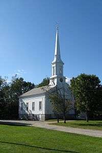
First Congregational Church | |
  | |
| Location | Royalston, Massachusetts |
|---|---|
| Coordinates | 42°40′39″N 72°11′18″W / 42.67750°N 72.18833°WCoordinates: 42°40′39″N 72°11′18″W / 42.67750°N 72.18833°W |
| Built | 1752 |
| Architect | Chase, Chauncey |
| Architectural style | Greek Revival, Second Empire, Federal |
| NRHP Reference # | [1] |
| Added to NRHP | December 12, 1976 |
Royalston Common Historic District is a historic district encompassing the historic village center of Royalston, Massachusetts. It is centered on a north-south stretch of Main Street (Massachusetts Route 68), between two separate complex junctions each involving three streets radiating out to neighboring towns. The town common, which this area is centered on, was laid out in 1752, and achieved its present shape about 1840. Flanking the common and lining the nearby roads are the town's major municipal buildings, with relatively little alteration since the 1850s.[2]
The district was listed on the National Register of Historic Places in 1976.[1] The common was named as one of the 1,000 places to visit in Massachusetts by the Great Places in Massachusetts Commission.[3]
See also
References
- 1 2 National Park Service (2008-04-15). "National Register Information System". National Register of Historic Places. National Park Service.
- ↑ "NRHP nomination for Royalston Common Historic District". Commonwealth of Massachusetts. Retrieved 2015-10-29.
- ↑ http://www.boston.com/news/local/massachusetts/articles/2010/07/12/1000_places_to_visit/
| Topics |  | ||||||||||||||||||||||||||||||
|---|---|---|---|---|---|---|---|---|---|---|---|---|---|---|---|---|---|---|---|---|---|---|---|---|---|---|---|---|---|---|---|
| Lists by county | |||||||||||||||||||||||||||||||
| Lists by city |
| ||||||||||||||||||||||||||||||
| Other lists | |||||||||||||||||||||||||||||||
| |||||||||||||||||||||||||||||||