Ruang
| Ruang | |
|---|---|
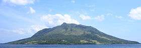 Ruang from the island of Tagulandang | |
| Highest point | |
| Elevation | 725 m (2,379 ft) [1] |
| Listing | Spesial Ribu |
| Coordinates | 2°18′N 125°22′E / 2.30°N 125.37°E |
| Geography | |
| Location | Sangihe Islands, Indonesia |
| Geology | |
| Mountain type | stratovolcano |
| Last eruption | September 2002 |
Ruang is the southernmost stratovolcano in the Sangihe Islands arc. It comprises an island 4 × 5 km wide. The summit contains a partial lava dome. The first recorded eruption was in 1808.[1]
See also
References
- 1 2 "Ruang". Global Volcanism Program. Smithsonian Institution. Retrieved 2006-12-18.
| Wikimedia Commons has media related to Ruang. |
This article is issued from Wikipedia - version of the 3/30/2016. The text is available under the Creative Commons Attribution/Share Alike but additional terms may apply for the media files.