Ruapuke
| Ruapuke | |
|---|---|
 | |
 Ruapuke | |
| Coordinates: 37°53′32″S 174°41′52″E / 37.89222°S 174.69778°ECoordinates: 37°53′32″S 174°41′52″E / 37.89222°S 174.69778°E | |
| Country | New Zealand |
| Region | Waikato |
| Territorial authority | Waikato District |
| Population (2006)http://apps.nowwhere.com.au/StatsNZ/Maps/default.aspx | |
| • Total | 66 |
| Time zone | NZST (UTC+12) |
| • Summer (DST) | NZDT (UTC+13) |
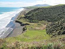
Ruapuke is a small farming community (predominantly sheep and cattle farmers) in the Waikato region on the slopes of Karioi, between Raglan and Kawhia in New Zealand.
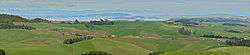
The photo on the right is of Ruapuke (to right) from Houchens Rd, Te Mata. On a fine winter's day (this was August 2010) Ruapuke residents can look over Aotea Harbour to a rugged and uninhabited coastline and, beyond, the snow-capped peak of Mt. Taranaki, 150 km away (right top – hard to distinguish from a cloud).
History
The introduction to 'Ruapuke' says, "The greater part of the Ruapuke District is of a sandy loam, and at one time carried a large population of Maoris, as is evidenced by old pas, great heaps of shells, whare [house] sites and numerous kumara storage pits. When the first Europeans arrived the sandy country was covered with patches of light bush, with a big proportion of Karaka, Puriri, and Cabbage trees. The balance was covered with Tauhinu, Teatree, Flax and Fern. The clay portion of the district, (inland and on the slopes of Mt Karioi) was in heavy bush."[1] The archaeological map shows over 40 sites in the area.[2] European settlers arrived from the 1850s.
Ruapuke had a school from 1877 till 1954.[1] It has been replaced by a school bus.[3]
Population
It comprises a handful (meshblock 0861800 - Ruapuke had 66 people in 21 households with a median age of 34 in 2006)[4] of families, some of whom have lived there for many generations.[1]
Roads
Ruapuke is 10 km from Te Mata. 8 km of Ruapuke Road has been sealed and some bends removed, but is still windy. It is often used for rally car competitions.[5]
Ruapuke is 27 km from Raglan via Whaanga Road and Te Toto Gorge, which is gravel, winding, mountainous and described as 'iconic' in descriptions of Rally New Zealand.[6]

Surfing
Until the 1990s the beach largely remained unknown, used by local residents and a few surfing and surfcasting fishing enthusiasts. International surfing competitions such as the Billabong (clothing) Pro and the Rip Curl Pro are now held at Ruapuke beach, providing conditions oblige.
References
- 1 2 3 Ruapuke: F J Trolove first printed 1970 lists 22 families living in Ruapuke in 1969, including chapters on Swann, Thomson, Jackson, Ward, Given and Trolove
- ↑ "NZAA Site Viewer". nzaa.eaglegis.co.nz. Retrieved 2016-01-08.
- ↑ "Buses". Te Mata School. Retrieved 2016-01-08.
- ↑ http://apps.nowwhere.com.au/StatsNZ/Maps/default.aspx
- ↑ http://www.fiatcarclub.co.nz/index.php?s=ruapuke
- ↑ http://www.nzherald.co.nz/sport/news/article.cfm?c_id=4&objectid=10724045
External links
- 1:50,000 map http://www.topomap.co.nz/NZTopoMap/nz53288/Ruapuke/Waikato
- Raglan Surf
- Wildcoast Ruapuke
- Surf co New Zealand
- Chinese junk at Ruapuke beach?
- Rip Curl pro at Ruapuke beach, 2006
- Billabong Teen pro at Ruapuke beach, 2006
- Raglan net
- BBC on Ruapuke surf
- Raglan Arts