Rue de la Ferronnerie
 | |
| Length | 114 m (374 ft) |
|---|---|
| Width | 16.6 m (54 ft) |
| Arrondissement | 1st |
| Quarter | Les Halles |
| Construction | |
| Completion | Before 1229 |
| Denomination | 1229 |
Coordinates: 48°51′37″N 2°20′52″E / 48.860238°N 2.347747°E
The Rue de la Ferronnerie is a street in the 1st arrondissement of Paris, in the Les Halles area.
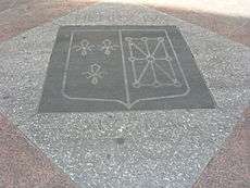
Marking on the street showing where Henry IV assassination took place
History
- Before 1229 the name of the street was rue de la Charronnerie (ou des Charrons). The street had its current name in 1229.
- Henry IV of France was assassinated by Ravaillac on May 14, 1610[1] A marking on the street shows where the event took place.
- One of the longest buildings in Paris is located on 2-4-6-8-10-12-14 rue de la Ferronnerie.[2] The building was constructed between 1669 and 1678.
References
External links
- Nomenclature officielle des voies de Paris
- Thierry Issartel, "Henri IV, les clés d'un règne", Gascogne Editing (Orthez), 2010.
This article is issued from Wikipedia - version of the 11/30/2016. The text is available under the Creative Commons Attribution/Share Alike but additional terms may apply for the media files.