Rural Address Property IDentification
RAPID is an acronym for Rural Address Property IDentification, a scheme instituted in New Zealand to assist emergency services in identifying and locating rural properties.
However, since the adoption of Australian/New Zealand Standard 4819:2003 Geographic Information – Rural and urban addressing in 2003, this scheme is now known as Rural Addressing.
The acronym RAPID has since been applied to a project of the New Zealand Ministry of Civil Defence and Emergency Management, entitled Response And Preparedness In Disasters
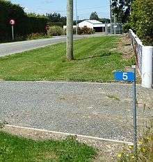
An example address of 1536 Longley Road can easily be found by dividing by 100. This tells anyone looking for the property, that it is 15.36 km from the start of Longley Road.
An emergency crew can set the vehicle trip meter at the beginning of the road and know they do not need to waste time checking for letterbox numbers until the trip meter gets close to the rapid number they are looking for.
Any rural property can have a rapid number, and some have multiple numbers for different entranceways off the road. This helps when a visitor needs to access stockyards or other parts of a rural property.