Rural Municipality of Glenwood
The Rural Municipality of Glenwood is a former rural municipality (RM) in the Canadian province of Manitoba. It was originally incorporated as a rural municipality on December 22, 1883.[1] It ceased on January 1, 2015 as a result of its provincially mandated amalgamation with the Town of Souris to form the Municipality of Souris – Glenwood.[2]
The RM was located in the southwestern corner of the province, approximately 47 kilometres southwest of Manitoba's second-largest city, Brandon. It was located at the junction of Manitoba Highway 2, running east and west, while Provincial Road 250 extends from north and Manitoba Highway 22 southward. Manitoba Highway 10 provides access to the United States. The RM of Glenwood was home to approximately 800 residents, excluding the residents of Souris.
Communities
- Hayfield
- Menteith
- Newstead
- Schwitzer
History
Though Glenwood was incorporated as a municipality in 1883, its history goes back further. In 1880, the first four permanent residents arrived and established homesteads along Plum Creek, approximately 1.5 kilometres west of what today is Souris. Most early settlers established homesteads in the Souris area, while others settled in the surrounding town sites. The 1880s saw vigorous immigration into the area, especially people who came from Ireland. By the end of 1883, the area was completely settled, and by 1884 the town site of Souris contained over 50 buildings. The Town of Souris was incorporated in 1904 as a separate municipal government, and its first mayor was A.L. Young.
Economic base
Glenwood's economy was primarily based in agriculture. The area featured grain, canola, flax, cattle, and pig farming.
Tourist attractions
A growing economic source in Glenwood is tourism. Souris features many attractions including an agate pit, four museums, bird sanctuary, golf course, river cruises, nature trails, and a swinging bridge. Many accommodations and businesses exist to serve the needs of tourists, including a fully serviced campground and hotel.
- Built in 1903, the Glenwood Swinging Bridge is a 177.4-metre foot bridge. The Glenwood areas agate pits also draw many tourists from all over the world who have come to collect many varieties of agates, several colors of jasper, petrified wood, and epidote found in the pits.
- The 20-acre (8.1 ha) Glenwood Victoria Park was donated by the Sowden family. It is located in the heart of Souris and features camping, picnicking, and swimming facilities. A bird sanctuary is located in the centre of the park where many different types of birds can be viewed.
- The old Squire Hall, restored as a historic site and named the Hillcrest Museum, features the original furniture of the mansion along with artifacts cherished by the early Souris settlers. An agricultural museum is found in the same location.
- The Plum is the site of the 1883 Souris Heritage Church built by early settlers. This building features Victorian architecture and the Souris Heritage Church Museum with a tea room with crafts.
- The Souris Fair Grounds provide Glenwood with a site for events that include baseball diamonds, a batting cage, a corral, barns, a judges booth, display buildings, and concession stands.
External links
References
- ↑ "Manitoba's Municipal History: Rural Municipalities and Local Government Districts". The Manitoba Historical Society. September 21, 2014. Retrieved January 2, 2015.
- ↑ "Manitoba's Municipal History: Municipal Amalgamations (2015)". The Manitoba Historical Society. December 1, 2014. Retrieved January 2, 2015.
- Geographic Names of Manitoba (pg. 94) - the Millennium Bureau of Canada
- Map of Glenwood R.M. at Statcan
Coordinates: 49°37′15″N 100°15′29″W / 49.62083°N 100.25806°W
| Cities | 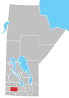 | |
|---|---|---|
| Towns | ||
| Rural municipalities | ||
| Unincorporated communities | ||