São Roque, São Paulo
| São Roque | |||
|---|---|---|---|
| Municipality | |||
| |||
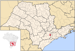 Location in São Paulo state | |||
 São Roque Location in Brazil | |||
| Coordinates: 23°31′45″S 47°08′07″W / 23.52917°S 47.13528°WCoordinates: 23°31′45″S 47°08′07″W / 23.52917°S 47.13528°W | |||
| Country |
| ||
| Region | Southeast Region | ||
| State | São Paulo | ||
| Metrop. region | Sorocaba | ||
| Government | |||
| • Mayor | Daniel de Oliveira Costa (PMDB) | ||
| Area | |||
| • Total | 306.91 km2 (118.50 sq mi) | ||
| Elevation | 771 m (2,530 ft) | ||
| Population (2015) | |||
| • Total | 86,515 | ||
| • Density | 280/km2 (730/sq mi) | ||
| Time zone | BRT/BRST (UTC-3/-2) | ||
| Postal code | 18130-000 | ||
| Area code | +55 11 | ||
| Website |
www | ||

São Roque (meaning Saint Roch in Portuguese) is a city in the state of São Paulo in Brazil. It is part of the Metropolitan Region of Sorocaba.[1] The population is 86,515 (2015 est.) in an area of 306.91 km².[2] The city is at an altitude of 771 m. São Roque is connected by two main highways: Rodovia Raposo Tavares and Rodovia Castelo Branco. It is located 60 km west from the state capital. Some of the neighboring municipalities are Cotia, Vargem Grande Paulista, Ibiúna, Mairinque and Aluminio.
São Roque has protected greenspaces and maintains itself as a lush ecological paradise. It has a good climate with a wonderful countryside. The Serra do Mar mountains cover the southeast. It has an excellent infrastructure, especially well-developed for wine production. In the 19th century, immigrants from Italy and Portugal arrived in São Roque to work in vineyards. Tourism is also a significant part of the economy. It holds the largest artificial ski park in Latin America, the Ski Mountain Park.
Persons
- Juca de Oliveira, actor
References
- ↑ Governo do Estado de São Paulo, Lei Complementar nº 1.241, de 8 de maio de 2014 at the Wayback Machine (archived 18 October 2014)
- ↑ Instituto Brasileiro de Geografia e Estatística
External links
- (Portuguese) http://www.guiasaoroque.com.br Website about São Roque
- (Portuguese) http://www.saoroque.sp.gov.br
- (Portuguese) São Roque on citybrazil.com.br