Sabine Field
 Sabine Field, Norwich University | |
| Full name | Sabine Athletic Field |
|---|---|
| Location | Northfield, Vermont |
| Owner | Norwich University |
| Capacity | 3,000 |
| Opened | 1921 |
| Tenants | |
| Norwich Cadets | |
Sabine Field is a 3,000 capacity stadium in Northfield, Vermont on the campus of the NCAA Division III-affiliated Norwich University. Opened in 1921, it serves as home to the school's football and track teams.[1] The field is named for the son of Dr. George K. Sabine, a member of Norwich's Class of 1868, who provided funds to purchase the athletic field's land[2]
Since 1958, Sabine Field area has also been home to a WWII-era M4 Sherman tank named "Sabine Sally". Placed in honor of "the Norwich Men who served in the Armored Forces in World War II" and dedicated by Norwich alumnus and Medal of Honor recipient Captain James M. Burt.[3][4]
Alumni March On
Each fall on the university's Alumni Weekend, Sabine Field hosts the Alumni March On. At this ceremony, all returning alumni parade by class on to the field with the current year's Corp of Cadets.[5]
Vermont ghost stories
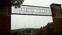
The gate to Sabine Field is a part of Vermont ghost story lore. In the tale, the gate to field is said to be guarded by an unseen cadet whose haunting footsteps can be heard.[6]
References
- ↑ 2007 Norwich University Football Media Guide (PDF), Norwich University Sports Information Office, retrieved 2008-02-22
- ↑ Norwich University Clickable Map: Sabine Field, Norwich University, archived from the original on 2008-02-16, retrieved 2008-02-22
- ↑ "In Memorium: CPT James M. Burt, USA, (Ret.)", Norwich Record, Norwich University Office of Communications, 99 (Spring 2006): 22, 2
- ↑ "From the University Archives: 45 Years Ago: The Tank Ceremony", Norwich Record, Norwich University Office of Communications, 96 (Summer 2003): 3, 3
- ↑ "Homecoming 2005: Full Weekend Coverage", Norwich Record, Norwich University Office of Communications, 98 (Fall 2005): 13–15, 4
- ↑ Vermont Ghost Stories and Hauntings, Vermonter.com, archived from the original on 2008-02-02, retrieved 2008-02-22
Coordinates: 44°8′29″N 72°39′36″W / 44.14139°N 72.66000°W