Saguenay flood
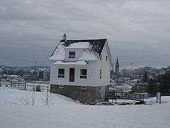 The "little white house" at Saguenay, in 2008. | |
| Date | July 19–20, 1996 |
|---|---|
| Location | Saguenay-Lac-Saint-Jean region of Quebec |
| Deaths | 10 |
| Property damage | CA$ $1.5 billion |
The Saguenay flood (French: Déluge du Saguenay) was a series of flash floods on July 19 and 20, 1996 that hit the Saguenay-Lac-Saint-Jean region of Quebec, Canada. It was the biggest overland flood in 20th-century Canadian history.[1]
Problems started after two weeks of constant rain, which severely engorged soils, rivers and reservoirs. The Saguenay region is a geological graben, which increased the effect of the sudden massive rains of July 19, 1996. In two days, rainfall accumulated that was "equivalent to the volume of water that tumbles over Niagara Falls in four weeks."[2]
Over 8 feet (2.4 m) of water flooded parts of Chicoutimi and La Baie, completely levelling an entire neighbourhood. More than 16,000 people were evacuated. The official death toll was seven, but other sources (notably Canadian Geographic[2]) cite ten. Estimates reach CAD $1.5 billion in damages, a cost made greater by the disaster's occurrence at the height of the tourist season. Post-flood enquiries discovered that the network of dikes and dams protecting the city of Chicoutimi was poorly maintained. In the end, 488 homes were destroyed, 1,230 damaged, and 16,000 people evacuated from the entire area. An additional ten persons died in the mudslides produced by the incredible rain.[1]
A small white house (referred to in French as La petite maison blanche, "The little white house") stood nearly unharmed in Chicoutimi while torrents of water rushed in every side, and it became the symbol of surviving the flood. It was owned Mme Jeanne d'Arc Lavoie-Genest. With its foundation still highly exposed after the flooding, it has been preserved in Saguenay (the city name has changed) as a historical park and museum commemorating the flood.[3]
An unexpected effect of the flood was to cover the heavily contaminated sediments at the bottom of the Saguenay and Ha! Ha! Rivers with 10 to 50 centimetres (3.9 to 19.7 in) of new, relatively clean sediments. Because of this, research has shown that the old sediments are no longer a threat to ecosystems and the river will not have to be dredged and treated to control contamination.[4]
Footnotes
- 1 2 SOS! Canadian Disasters, a virtual museum exhibition at Library and Archives Canada
- 1 2 The Saguenay flood: After the deluge
- ↑ La Petite maison blanche
- ↑ Project Saguenay
External links
- CBC Digital Archives - The Saguenay Flood
- "Bilan du Siècle", University of Sherbrooke (French)
- Meteorological Service of Canada: Top Ten Weather Stories of 1996
- Project Saguenay, The scientific team doing research on the ecological effects of the flood.
Coordinates: 48°25′30″N 71°04′34″W / 48.42500°N 71.07611°W