Saint-Amand-Montrond
| Saint-Amand-Montrond | ||
|---|---|---|
|
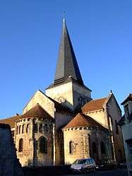
The church of Saint-Amand, in Saint-Amand-Montrond | ||
| ||
 Saint-Amand-Montrond | ||
|
Location within Centre-Val de Loire region  Saint-Amand-Montrond | ||
| Coordinates: 46°42′N 2°31′E / 46.70°N 2.51°ECoordinates: 46°42′N 2°31′E / 46.70°N 2.51°E | ||
| Country | France | |
| Region | Centre-Val de Loire | |
| Department | Cher | |
| Arrondissement | Saint-Amand-Montrond | |
| Canton | Saint-Amand-Montrond | |
| Government | ||
| • Mayor (2008–2014) | Thierry Vinçon | |
| Area1 | 20.17 km2 (7.79 sq mi) | |
| Population (2008)2 | 11,376 | |
| • Density | 560/km2 (1,500/sq mi) | |
| Time zone | CET (UTC+1) | |
| • Summer (DST) | CEST (UTC+2) | |
| INSEE/Postal code | 18197 / 18200 | |
| Elevation |
148–312 m (486–1,024 ft) (avg. 162 m or 531 ft) | |
|
1 French Land Register data, which excludes lakes, ponds, glaciers > 1 km² (0.386 sq mi or 247 acres) and river estuaries. 2 Population without double counting: residents of multiple communes (e.g., students and military personnel) only counted once. | ||
.svg.png)
Saint-Amand-Montrond (French: [sɛ̃.t‿a.mɑ̃.mɔ̃.tʁɔ̃]) is a commune in the Cher department in the Centre region of France and le Berry. It is sourouned by the French countryside but has Le Châtre nearby.
Saint-Amand-Montrond has many notable features. Firstly the Berry Canal runs through it and now small electronic boats can be hired to ride briefly on the canal. In the outskirts is an iconic glass pyramid 'le cité d'or' (the golden city or the city of gold) it is a museum dedicated to the global history of gold around the world. In the town centre there are two town squares, one has the bandstand with public toilets underneath, surrounded by a car park and shops. The town centre has a wide variety of shops in the beautiful, charming and typical French streets between the two squares. The second one has a fountain has the centre piece; a small children's play area in the corner; a smaller car park; a family-friendly pub, that sponsors Saint-Armand-Montrond football team and a group of shops ranging from a farm shop to a friendly boulangerie to a crêperie. It is a lovely town to visit.
Saint-Amand-Montrond literally translates to Saint Amand round hill, despite not being on a round hill.
Geography
A small town of farming and a little light industry situated some 26 miles (42 km) southeast of Bourges, at the junction of the D951 with the D300 and D2144 roads. The town was built in the basin of the eastern banks of the Cher River which separates it from the commune of Orval, to which it is connected by two bridges.
A small river, the Marmande, joins the Cher here, and the canal de Berry crosses the commune from southeast to southwest. Some flooding is common because of the nearby marshes. The town is the capital of the small region of Boischaut, known for its woodland and cattle pastures.
Population
| Historical population | ||
|---|---|---|
| Year | Pop. | ±% |
| 1962 | 10,890 | — |
| 1968 | 11,495 | +5.6% |
| 1975 | 12,278 | +6.8% |
| 1982 | 12,451 | +1.4% |
| 1990 | 11,937 | −4.1% |
| 1999 | 11,447 | −4.1% |
| 2008 | 11,376 | −0.6% |
History
The settlement of Saint-Amand goes back to prehistoric times. Evidence of Roman occupation has also been discovered here. An abbey was founded here around the year 620 by a monk called Theodulph. The commune was created after the French Revolution by the amalgamation of three separate small towns that had grown up during the Middle Ages: Saint Amand le Chastel, Montrond and Saint Amand sous Montrond.
Sights
- The church of Saint Amandus, dating from the eleventh century.
- Several houses dating from the fifteenth century.
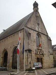
- The church of a Carmelite convent dating from the fifteenth century.
- A chapel from the convent, nowadays the town hall (hôtel de ville).
- Château de Montrond, a thirteenth-century castle, a historic site.
- The chateau of La Férolle.
- Vestiges of the twelfth-century castle of Saint-Amand-le-Chatel.
- The museum of Saint-Vic.
Personalities
- Jean-Baptiste Lemire (1867–1945), composer.
- Louis Lecoin (1888–1971), pacifist and libertarian, was born in Saint-Amand-Montrond.
- Maurice Papon (1910–2007), mayor of Saint-Amand-Montrond (1971–1983) and collaborator during World War II.
- Serge Vinçon (1949–2007), college professor and politician was born here.
- Jean Godin des Odonais, cartographer and explorer, lived here.
Economy
The town is noted for its goldsmiths and jewellers. It has 9 companies specialising in gold work as well as a professional school dedicated to jewellery.
Two large printing companies, Bussière and Clerc, produce large volumes of books and magazines.
Twin towns
See also
- Prix Alain-Fournier - literary prize awarded at the town's annual book fair
References
External links
| Wikimedia Commons has media related to Saint-Amand-Montrond. |
- Official website of the town (French)
- Annuaire Marie website (French)
- Saint-Amand-Montrond on the Quid website (French)
- L'abbaye de Noirlac