Saint-Laurent-de-Trèves
| Saint-Laurent-de-Trèves | ||
|---|---|---|
|
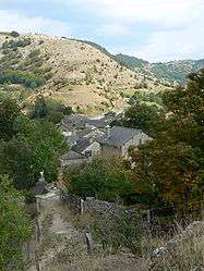
A general view of Saint-Laurent-de-Trèves | ||
| ||
 Saint-Laurent-de-Trèves | ||
|
Location within Occitanie region  Saint-Laurent-de-Trèves | ||
| Coordinates: 44°16′19″N 3°36′12″E / 44.2719°N 3.6033°ECoordinates: 44°16′19″N 3°36′12″E / 44.2719°N 3.6033°E | ||
| Country | France | |
| Region | Occitanie | |
| Department | Lozère | |
| Arrondissement | Florac | |
| Canton | Le Collet-de-Dèze | |
| Intercommunality | Tarnon-Mimente | |
| Government | ||
| • Mayor (2008–2014) | Paul Pascual | |
| Area1 | 23.09 km2 (8.92 sq mi) | |
| Population (1999)2 | 136 | |
| • Density | 5.9/km2 (15/sq mi) | |
| Time zone | CET (UTC+1) | |
| • Summer (DST) | CEST (UTC+2) | |
| INSEE/Postal code | 48166 / 48400 | |
| Elevation |
568–1,166 m (1,864–3,825 ft) (avg. 900 m or 3,000 ft) | |
|
1 French Land Register data, which excludes lakes, ponds, glaciers > 1 km² (0.386 sq mi or 247 acres) and river estuaries. 2 Population without double counting: residents of multiple communes (e.g., students and military personnel) only counted once. | ||
.svg.png)
Saint-Laurent-de-Trèves is a former commune in the Lozère department in southern France. On 1 January 2016, it was merged into the new commune of Cans-et-Cévennes.[1]
See also
References
- ↑ Arrêté préfectoral 2-14 December 2015
| Wikimedia Commons has media related to Saint-Laurent-de-Trèves. |
This article is issued from Wikipedia - version of the 3/15/2016. The text is available under the Creative Commons Attribution/Share Alike but additional terms may apply for the media files.