Saint-Martin-en-Campagne
| Saint-Martin-en-Campagne | |
|---|---|
 Saint-Martin-en-Campagne | |
|
Location within Normandy region  Saint-Martin-en-Campagne | |
| Coordinates: 49°57′28″N 1°13′21″E / 49.9578°N 1.2225°ECoordinates: 49°57′28″N 1°13′21″E / 49.9578°N 1.2225°E | |
| Country | France |
| Region | Normandy |
| Department | Seine-Maritime |
| Arrondissement | Dieppe |
| Canton | Dieppe-2 |
| Government | |
| • Mayor (2001–2008) | Bernard Defoy |
| Area1 | 6.85 km2 (2.64 sq mi) |
| Population (2006)2 | 1,266 |
| • Density | 180/km2 (480/sq mi) |
| Time zone | CET (UTC+1) |
| • Summer (DST) | CEST (UTC+2) |
| INSEE/Postal code | 76618 / 76370 |
| Elevation |
0–128 m (0–420 ft) (avg. 118 m or 387 ft) |
|
1 French Land Register data, which excludes lakes, ponds, glaciers > 1 km² (0.386 sq mi or 247 acres) and river estuaries. 2 Population without double counting: residents of multiple communes (e.g., students and military personnel) only counted once. | |
Saint-Martin-en-Campagne is a former commune in the Seine-Maritime department in the Normandy region in northern France. On 1 January 2016, it was merged into the new commune of Petit-Caux.[1]
Geography
A coastal farming village situated in the Pays de Caux, at the junction of the D113, D313 and the D925 roads, some 5 miles (8.0 km) east of Dieppe. Huge chalk cliffs rise up over a pebble beach and overlook the English Channel. The Penly Nuclear Power Plant is also sited in this commune.
Heraldry
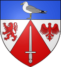 |
The arms of Saint-Martin-en-Campagne are blazoned : Gules, a sword, on a chapé argent a lion and an alerion gules, and on a chief azure, a seagull proper. |
Population
| 1962 | 1968 | 1975 | 1982 | 1990 | 1999 | 2006 |
|---|---|---|---|---|---|---|
| 484 | 544 | 562 | 833 | 1104 | 1000 | 1266 |
| Starting in 1962: Population without duplicates | ||||||
Places of interest
- The church of Notre-Dame, dating from the fifteenth century.
- A stone cross from the sixteenth century.
- The Penly Nuclear Power Plant on the coast, with two reactors of 1300 MW each.
See also
References
- ↑ Arrêté préfectoral 26 November 2015 (French)
External links
| Wikimedia Commons has media related to Saint-Martin-en-Campagne. |
This article is issued from Wikipedia - version of the 3/14/2016. The text is available under the Creative Commons Attribution/Share Alike but additional terms may apply for the media files.