Saint-Patrice-de-Claids
| Saint-Patrice-de-Claids | |
|---|---|
 | |
 Saint-Patrice-de-Claids | |
|
Location within Normandy region  Saint-Patrice-de-Claids | |
| Coordinates: 49°13′51″N 1°26′09″W / 49.2308°N 1.4358°WCoordinates: 49°13′51″N 1°26′09″W / 49.2308°N 1.4358°W | |
| Country | France |
| Region | Normandy |
| Department | Manche |
| Arrondissement | Coutances |
| Canton | Lessay |
| Intercommunality | Canton of Lessay |
| Government | |
| • Mayor (2008–2014) | Jean-Luc Launey |
| Area1 | 5.58 km2 (2.15 sq mi) |
| Population (1999)2 | 163 |
| • Density | 29/km2 (76/sq mi) |
| Time zone | CET (UTC+1) |
| • Summer (DST) | CEST (UTC+2) |
| INSEE/Postal code | 50533 / 50190 |
| Elevation |
9–34 m (30–112 ft) (avg. 32 m or 105 ft) |
|
1 French Land Register data, which excludes lakes, ponds, glaciers > 1 km² (0.386 sq mi or 247 acres) and river estuaries. 2 Population without double counting: residents of multiple communes (e.g., students and military personnel) only counted once. | |
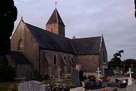
Church
Saint-Patrice-de-Claids is a commune in the Manche department in Normandy in north-western France.
See also
References
| Wikimedia Commons has media related to Saint-Patrice-de-Claids. |
This article is issued from Wikipedia - version of the 2/25/2015. The text is available under the Creative Commons Attribution/Share Alike but additional terms may apply for the media files.