Saint Helena, Ascension and Tristan da Cunha
| Saint Helena, Ascension and Tristan da Cunha |
||||
|---|---|---|---|---|
|
||||
| Anthem: "God Save the Queen" | ||||
.svg.png) |
||||
| Status | British Overseas Territory | |||
| Capital | Jamestown[1] 15°56′S 005°43′W / 15.933°S 5.717°W | |||
| Largest settlement | Half Tree Hollow 15°56′0″S 5°43′12″W / 15.93333°S 5.72000°W | |||
| Official languages | English | |||
| Parts | ||||
| Leaders | ||||
| • | Monarch | Elizabeth II | ||
| • | Governor | Lisa Phillips | ||
| • | Administrator of Ascension Island | Marc Holland[2] | ||
| • | Administrator of Tristan da Cunha | Alex Mitham | ||
| Established as a dependency of the United Kingdom | ||||
| • | St Helena charter granted | 1657 | ||
| • | East India Company rule ended | 22 April 1834[3] | ||
| • | Ascension added | 12 September 1922 | ||
| • | Tristan da Cunha added | 12 January 1938 | ||
| • | Current constitution | 1 September 2009 | ||
| Area | ||||
| • | Total | 394 km2 152 sq mi |
||
| Population | ||||
| • | 2014 census | 7,729 (219th) | ||
| • | Density | 13.4/km2 34.7/sq mi |
||
| Currency |
|
|||
| Time zone | GMT (UTC) | |||
| Drives on the | left | |||
| Calling code | ||||
| ISO 3166 code | SH | |||
| Internet TLD | ||||
| a. | For the Overseas Territories. | |||
Saint Helena, Ascension and Tristan da Cunha[4] is a British Overseas Territory located in the South Atlantic and consisting of the island of Saint Helena, Ascension Island and the archipelago of Tristan da Cunha.
Its name was Saint Helena and Dependencies until 1 September 2009, when a new constitution came into force giving the three islands equal status within the territory.[5] Despite this change, the whole territory is still commonly referred to as simply Saint Helena after its main island. Similarly, the demonym Saint Helenians (or "Saints") and the derived name for the local nationality is commonly understood to include Ascension Islanders and Tristanians, as well.[6]
Administrative divisions
Administratively, the territory is divided into the same three parts as the territory's geography, namely Saint Helena, Ascension and Tristan da Cunha. Each is governed by a council. The Governor of the territory presides over the Saint Helena Legislative Council, while he or she is represented by an Administrator on Ascension Island and an Administrator on Tristan da Cunha that preside over these two areas' Island Councils. See Constitution section below.
| Administrative area |
Area km2 | Area sq mi | Population | Administrative centre |
|---|---|---|---|---|
| Saint Helena | 122 | 47 | 5,809 | Jamestown |
| Ascension Island | 88 | 34 | 1,532 | Georgetown |
| Tristan da Cunha | 184 | 71 | 264 | Edinburgh of the Seven Seas |
| Tristan da Cunha | 98 | 38 | 264 | |
| Inaccessible Island | 14 | 5 | 0 | |
| Nightingale Island | 3.2 | 1 | 0 | |
| Gough Island | 68 | 26 | 0 (9 non-permanent inhabitants) | |
| Total | 394 | 152 | 7,614 | Jamestown |
The island of St Helena is then further divided into eight districts.[7]
History
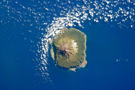
Of volcanic origin, the islands of Saint Helena, Ascension Island, and Tristan da Cunha were all formerly separate colonies of the English crown, though separately discovered by several Portuguese explorers between 1502 and 1504.
Portuguese discovery
The Portuguese found Saint Helena uninhabited, with an abundance of trees and freshwater. They imported livestock, fruit trees and vegetables, and built a chapel and one or two houses. Though they formed no permanent settlement, the island became crucially important for the collection of food and as a rendezvous point for homebound voyages from Asia. Englishman Sir Francis Drake very probably located the island on the final lap of his circumnavigation of the world (1577–1580).[8] Further visits by other English explorers followed, and, once St Helena's location was more widely known, English warships began to lie in wait in the area to attack Portuguese carracks on their way home from India. In developing their Far East trade, the Dutch also began to frequent the island and made a formal claim to it in 1633, but did not settle the isle and by 1651 largely abandoned it in favour of their colony at the Cape of Good Hope.
English and British colonisation
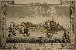
In 1657 the English East India Company was granted a charter to govern Saint Helena by Oliver Cromwell,[9] and the following year the Company decided to fortify and colonise the island with planters. The first governor, Captain John Dutton, arrived in 1659, and it is from this date that St Helena claims to be Britain’s second oldest remaining colony, after Bermuda. A fort was completed and a number of houses were built. After the Restoration of the English monarchy in 1660, the East India Company received a Royal Charter giving it the sole right to fortify and colonise the island. The fort was renamed James Fort and the town Jamestown, in honour of the Duke of York and heir apparent, later King James II of England.
The Kingdom of England became part of the new Kingdom of Great Britain in 1707 and then the United Kingdom in 1801; the British Empire grew into a global great power. The most important and first settled, the island of Saint Helena, had been governed by the East India Company since 1659. It became internationally known as the British government's chosen place of exile of Napoleon Bonaparte, who was detained on the island from October 1815 until his death on 5 May 1821, and it was made a British crown colony in 1834 by the Government of India Act 1833.[3] Unoccupied Ascension Island was garrisoned by the Royal Navy on 22 October 1815, shortly after which the end of the Age of Sail made its difficult location in the equatorial doldrums less important relative to its strategic importance as a centrally positioned naval coaling station. For similar reasons Tristan da Cunha was annexed as a dependency of the Cape Colony (British South Africa) on 14 August 1816, at the settlement of the Napoleonic wars. For a short period just prior, Tristan da Cunha had been inhabited by a private American expedition who named the territory the Islands of Refreshment.
The political union between these colonies began to take shape on 12 September 1922, when by letters patent Ascension Island became a dependency of Saint Helena. Lightly populated Tristan da Cunha, even today little more than an outpost with a population of less than three hundred, followed suit on 12 January 1938. The three island groups shared this constitutional relationship until 1 September 2009, when the dependencies were raised to equal status with St. Helena and the territory changed its name from "Saint Helena and Dependencies" to "Saint Helena, Ascension and Tristan da Cunha".
World War II and subsequent military presence
During the Battle of the Atlantic of World War II and the following several years of U-boat warfare in the Atlantic, both Saint Helena and Ascension Island were used by the Allies to base patrolling anti-surface-commerce-raider and anti-submarine warfare (ASW) forces against the Axis powers' naval units. Initially long range naval patrol flying boats were used in the effort, and later in the war during the struggle to improve air coverage over the commercially important sea lanes, air strips were built to support land based aircraft which supplied, augmented and complemented the PBY Catalina patrol planes in the vitally important ASW mission.
The United States and Great Britain still jointly operate the airfield (RAF Ascension Island) on Ascension, which also serves as a space-based communications, signals intelligence, and navigation nexus and hub (Ground station). One of only four GPS satellite ground antennas is located there.
Geography
The territory stretches across a huge distance of the South Atlantic Ocean with the northern-most island, Ascension, having a latitude of 7° 56′ S of the equator and the southern-most island, Gough Island, at 40° 19′ S. Between Saint Helena and Tristan da Cunha is the Tropic of Capricorn. The distance between the northern tip of Ascension Island and the southern tip of Gough Island is 2,263 miles (3,642 km) (an equivalent distance between London and the Dead Sea). The whole territory lies in the Western Hemisphere and has the same time zone: Greenwich Mean Time. Daylight saving time is not observed.
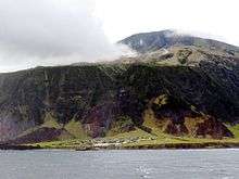
Ascension has a warm, arid climate, whereas St Helena is more moderated (and arid near the coasts) and Tristan much cooler. The highest point of the territory is Queen Mary's Peak on the island of Tristan da Cunha, with an elevation of 2,062 metres (6,765 ft) above sea level. The mountain is listed as an ultra prominent peak.
Although all three parts of the territory were formed by volcanic activity, only the Tristan da Cunha group of islands are volcanically active at the moment.
Territorial waters
The territorial waters of the islands extend out to 12 nautical miles (22 km) from their coastal baselines. The Exclusive Economic Zones (EEZs) extend 200 nautical miles (370 km) from the islands' baselines. Despite their size, the three EEZs do not overlap or touch one another, nor do they reach the EEZs of any other country or territory. The territory has the largest EEZ of any of the British overseas territories (indeed larger than the United Kingdom's) and if included in the ranking of countries by size of EEZ, the territory would be 21st, behind Portugal and ahead of the Philippines. Neither the islands nor their EEZs are the subject of any current international dispute.
| Part | km2 | sq mi |
|---|---|---|
| Ascension Island | 441,658 | 170,525 |
| Saint Helena | 444,916 | 171,783 |
| Tristan da Cunha | 754,720 | 291,400 |
| Total | 1,641,294 | 633,708 |
An application was made in 2008 by the United Kingdom to the United Nations Commission on the Limits of the Continental Shelf to extend the limit of the continental shelf claim of Ascension Island beyond 200 nautical miles (370 km). The Commission recommended in 2010 that the limit not be extended beyond the standard limit, based on scientific surveys.[11]
Constitution
The Saint Helena, Ascension and Tristan da Cunha Constitution Order 2009 (an Order in Council of the Privy Council of the United Kingdom) enacted a new constitution for the territory, which came into effect on 1 September 2009. Although raising Ascension and Tristan da Cunha to equal status with Saint Helena, the constitution is divided into three chapters, one for each part of the territory. Saint Helena has a Governor and a Legislative Council, whilst Tristan da Cunha and Ascension each have an Administrator and an Island Council. Notably the constitution includes (for each part of the territory) the "fundamental rights and freedoms of individuals".[5]
| Part | Crown representative | Council |
|---|---|---|
| Saint Helena | Governor of Saint Helena | Legislative Council of Saint Helena |
| Ascension Island | Administrator of Ascension Island | Ascension Island Council |
| Tristan da Cunha | Administrator of Tristan da Cunha | Tristan da Cunha Island Council |
Saint Helena also has an Executive Council. The Governor of Saint Helena is the British monarch's representative across the territory. The three parts of the territory share the same Attorney General, and the same Supreme Court and Court of Appeal.
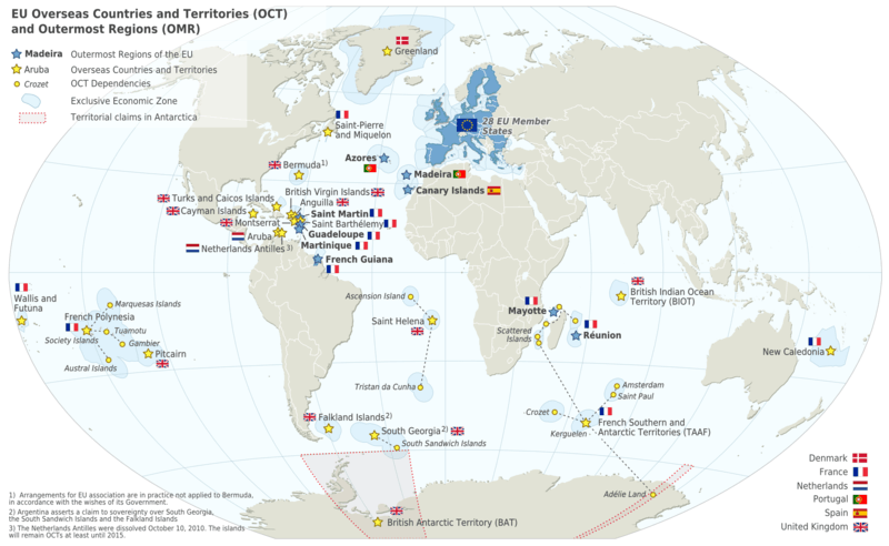
European Union
The territory is an Overseas Country or Territory of the European Union, with limited aspects of European Union membership applied to its administration, its laws and its citizens. It does not however form part of the European Union (the only British overseas territory that does is Gibraltar).
Religion
Most residents of St. Helena belong to the Anglican Communion and are members of the Diocese of St Helena, which has its own bishop and includes Ascension Island.
The Catholics are pastorally served by the Missio sui iuris of Saint Helena, Ascension and Tristan da Cunha, whose office of ecclesiastical superior is vested in the Apostolic Prefecture of the Falkland Islands.
Currency
Saint Helena used sterling currency as in the United Kingdom until 1976 when it began to issue its own banknotes at par with sterling. In 1984, the territory also began to issue its own coinage, similar to the coinage of the United Kingdom but with different designs on the reverse. The Saint Helena currency also circulates on Ascension Island, but not in the other part of the territory, Tristan da Cunha, where UK currency circulates.
The Currency Commissioners, part of the Government of Saint Helena, issue the St Helena pound banknotes and coins. There is no central bank, with the currency pegged to pound sterling which is controlled by the Bank of England in London. The Bank of Saint Helena is the territory's only bank. The bank sets its own deposit and lending rates and has branches in Jamestown on Saint Helena and Georgetown on Ascension Island. Although the bank does not have a physical presence on Tristan da Cunha, the residents of Tristan are entitled to use its services.[12]
Communications
Telecommunications
Sure South Atlantic provide the telecommunications service in the territory. Saint Helena has the international calling code +290 which, since 2006, Tristan da Cunha shares. Telephone numbers are four digits long. Numbers start with 1–9, with 8xxx being reserved for Tristan da Cunha numbers and 2xxx for Jamestown.[13] Ascension Island has the calling code +247 and also has four-digit numbers on the island.[14] Ascension Island also held an extensive broadcast facility for international shortwave transmissions to Africa and South America.
Ascension Island, Tristan da Cunha and Saint Helena all issue their own postage stamps, which provide a significant income. The three main islands of the territory each has their own Royal Mail postal code:
- Ascension Island: ASCN 1ZZ
- Saint Helena: STHL 1ZZ
- Tristan da Cunha: TDCU 1ZZ
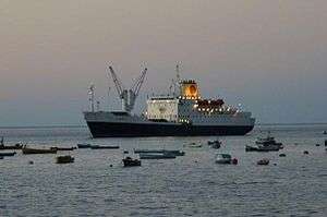
The last operating Royal Mail Ship — RMS St Helena — runs to and from Cape Town (and less frequently to and from the UK, and sometimes via Walvis Bay in Namibia) to the islands. It is expected to continue until the construction of the airport on Saint Helena island.
Transport
Maritime transport
Each of the three main islands has a harbour or small port, situated in the islands' chief settlement (Georgetown, Jamestown, and Edinburgh).
Airports
A military airfield exists on Ascension Island (RAF Ascension Island) with regular flights between RAF Brize Norton in the UK. These are primarily for RAF use, though some civilian use is permitted. Ascension Island is also used by the US military (which supply the base using MV Ascension) and was a designated emergency landing site for the Space Shuttle program. At present there is a civilian airport on Saint Helena island, with no schedule flights. The islands of Tristan da Cunha are connected only by sea.
Vehicular traffic
Saint Helena has 138 kilometres (86 mi)—118 kilometres (73 mi) paved and 20 kilometres (12 mi) unpaved—of roads. Tristan da Cunha has approximately 10 kilometres (6.2 mi) of paved roads, while Ascension has around 40 kilometres (25 mi) paved.[15] Each island has its own vehicle registration plate system. Traffic drives on the left in all three parts of the territory, as is the case in the United Kingdom itself. Indeed, two of the nearest countries to the islands—South Africa and Namibia—also drive on the left.
Maps
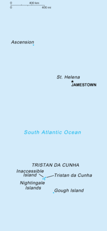 Map showing all of the islands
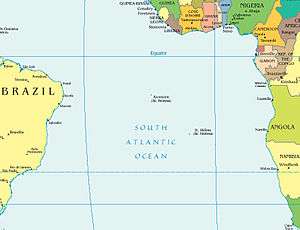 Location of Saint Helena and Ascension Island
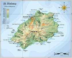 Map of St Helena island
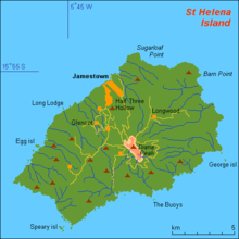 Another map of St Helena
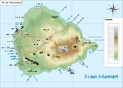 Map of Ascension Island
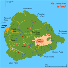 Another map of Ascension Island
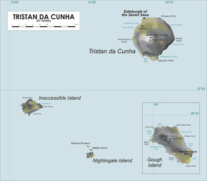 Map of Tristan da Cunha group
See also
- Bibliography of Saint Helena, Ascension and Tristan da Cunha
- British Overseas Territories
- List of towns in Saint Helena, Ascension and Tristan da Cunha
- Public holidays in Saint Helena, Ascension and Tristan da Cunha
References
- ↑ https://www.cia.gov/library/publications/the-world-factbook/geos/sh.html
- ↑ http://www.ascension-island.gov.ac/government/administrator/
- 1 2 St Helena, Ascension and Tristan da Cunha Constitution Order 2009 "...the transfer of rule of the island to His Majesty's Government on 22 April 1834 under the Government of India Act 1833, now called the Saint Helena Act 1833" (Schedule Preamble)
- ↑ "St Helena, Ascension and Tristan da Cunha Constitution Order 2009, see "EXPLANATORY NOTE"".
- 1 2 The St Helena, Ascension and Tristan da Cunha Constitution Order 2009 The Constitution (in the Schedule to the Order).
- ↑
- ↑ GeoHive St Helena.
- ↑ Drake and St Helena, privately published by Robin Castell in 2005
- ↑ "History: St. Helena homepage".
- ↑ Seaaroundus.org
- ↑ Commission on the Limits of the Continental Shelf Summary of recommendations re: Ascension Island
- ↑ "The Bank of Saint Helena". Sainthelenabank.com. Retrieved 2010-04-18.
- ↑ World Telephone Numbering Guide Saint Helena and Tristan da Cunha
- ↑ World Telephone Numbering Guide Ascension Island
- ↑ CIA World Factbook St Helena, Ascension and Tristan da Cunha
External links
| Wikimedia Commons has media related to Saint Helena, Ascension and Tristan da Cunha. |
| Wikivoyage has a travel guide for Saint Helena, Ascension and Tristan da Cunha. |
- The Official Government Website of Saint Helena
- The Official Government Website of Ascension Island
- The Official Tristan da Cunha Website
- Radio Saint FM (live broadcasting from Saint Helena)
- St Helena Online (UK-based news website, in partnership with the St Helena Independent)
- "Saint Helena, Ascension and Tristan da Cunha". The World Factbook. Central Intelligence Agency.
| |
.svg.png)