Jacob's Ladder (Saint Helena)
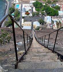
Jacob's Ladder is a Grade I-listed staircase leading from Jamestown, Saint Helena up the side of Ladder Hill to Ladder Hill Fort. It was originally built as a funicular in the early 1800s, but the rails and cars were later removed. This left the stairs in place, which have now become a tourist attraction connecting Jamestown and the suburb of Half Tree Hollow at the top of the hill.
History and description
Designed by the local engineer J. W. Hoar, the Saint Helena Railway Company built a two-car funicular, 924 feet (281.6 m)-long, in 1829 to carry cargo between Jamestown and the fort. The cars rode on a pair of iron-plated fir rails, laid on wooden sleepers anchored into the rock of the valley wall, that were separated by a staircase of 700 steps for pedestrians. The angle of ascent varied between 39 and 41 degrees. Motive power was provided by a team of three donkeys at the top that rotated a capstan connected to the cars by an iron chain and pulleys.[1][2]
Termite damage to the sleepers caused the Royal Engineers to remove the cars, rails and associated machinery in 1871, and it is now known as Jacob’s Ladder. Subsequent roadwork has covered over 1 step and only 699 remain. Lights were installed along the sides of the stairs in 2000 and the steps were refurbished in 2006.[3] The staircase has been declared a Grade I-listed structure.[4] During the island's annual "Festival of Running", a timed run takes place up Jacob's Ladder, with people coming from around the world to take part. As of 2016, the record time to ascend the stairs is 5 minutes, 16.78 seconds.[3]
References
- ↑ Azéma, Michel. "(SH) St. Helena - Ladder Hill Railway (1829) - Funimag photoblog". Funimag photoblog. Retrieved 27 November 2016.
- ↑ "Articles about the Ladder Hill incline in the Mechanics Magazine 1832 and 1834". www.railwaysofthefarsouth.co.uk. Retrieved 27 November 2016.
- 1 2 "Jacob's Ladder". sainthelenaisland.info. Retrieved 27 November 2016.
- ↑ "Saint Helena Historical Environmental Record". www.blackfreighter.net. Retrieved 27 November 2016.
Coordinates: 15°55′32″S 5°43′09″W / 15.9256°S 5.7192°W