Salins-les-Bains
| Salins-les-Bains | ||
|---|---|---|
 | ||
| ||
 Salins-les-Bains | ||
|
Location within Bourgogne-Franche-Comté region  Salins-les-Bains | ||
| Coordinates: 46°56′31″N 5°52′45″E / 46.9419°N 5.8792°ECoordinates: 46°56′31″N 5°52′45″E / 46.9419°N 5.8792°E | ||
| Country | France | |
| Region | Bourgogne-Franche-Comté | |
| Department | Jura | |
| Arrondissement | Lons-le-Saunier | |
| Canton | Salins-les-Bains | |
| Government | ||
| • Mayor (2014–2020) | Gilles Beder | |
| Area1 | 24.68 km2 (9.53 sq mi) | |
| Population (2013)2 | 2,796 | |
| • Density | 110/km2 (290/sq mi) | |
| Time zone | CET (UTC+1) | |
| • Summer (DST) | CEST (UTC+2) | |
| INSEE/Postal code | 39500 / 39110 | |
| Elevation |
284–737 m (932–2,418 ft) (avg. 350 m or 1,150 ft) | |
|
1 French Land Register data, which excludes lakes, ponds, glaciers > 1 km² (0.386 sq mi or 247 acres) and river estuaries. 2 Population without double counting: residents of multiple communes (e.g., students and military personnel) only counted once. | ||

Salins-les-Bains is a commune in the Jura department in the region of Bourgogne-Franche-Comté in eastern France.
Salins owes its name to its saline waters, used for bathing and drinking. There are also salt works and gypsum deposits. In 2009 the historic saltworks were added to the list of UNESCO World Heritage sites. The saltworks at Salins-Les-Bains are closely associated with another World Heritage site, the Royal Saltworks at Arc-et-Senans.
Geography
Salins is situated in the narrow valley of the Furieuse, between two fortified hills, Fort Belin and Fort Saint-André, while to the north rises Mont Poupet (851 m).
History
The territory of Salins, which was enfeoffed in the 10th century by the Abbey of Saint Maurice-en-Valais to the counts of Mâcon, remained in possession of their descendants till 1175. Maurette de Salins, heiress of this dynasty, brought the lordship to the house of Vienne, and her granddaughter sold it in 1225 to Hugh IV of Burgundy, who ceded it in 1237 to John of Chalon in exchange for the county of Chalon. John's descendants, counts and dukes of Burgundy, emperors and kings of the house of Austria all bore the title of sire de Salins.
In 1477 Salins was taken by the French and temporarily made the seat of the parliament of Franche-Comté by Louis XI. In 1668 and 1674 it was retaken by the French and thenceforward remained in their power. In 1825 the town was almost destroyed by fire. In 1871 it successfully resisted the German troops in the Franco-Prussian War.
Population
| Historical population | ||
|---|---|---|
| Year | Pop. | ±% |
| 1793 | 8,174 | — |
| 1806 | 8,374 | +2.4% |
| 1821 | 7,271 | −13.2% |
| 1831 | 6,554 | −9.9% |
| 1841 | 7,481 | +14.1% |
| 1851 | 7,112 | −4.9% |
| 1861 | 7,361 | +3.5% |
| 1872 | 6,045 | −17.9% |
| 1881 | 5,319 | −12.0% |
| 1891 | 6,068 | +14.1% |
| 1901 | 5,525 | −8.9% |
| 1911 | 5,272 | −4.6% |
| 1921 | 4,471 | −15.2% |
| 1931 | 4,607 | +3.0% |
| 1946 | 4,363 | −5.3% |
| 1954 | 4,930 | +13.0% |
| 1962 | 4,451 | −9.7% |
| 1968 | 4,259 | −4.3% |
| 1975 | 4,177 | −1.9% |
| 1982 | 3,923 | −6.1% |
| 1990 | 3,629 | −7.5% |
| 1999 | 3,333 | −8.2% |
| 2008 | 2,987 | −10.4% |
| 2013 | 2,796 | −6.4% |
Sights
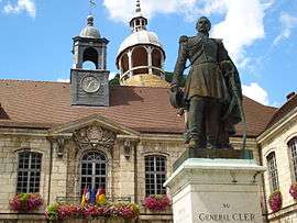
The town has a Romanesque church, St-Anatoile, which has been well restored, and an hôtel de ville from the 18th century. A 17th-century Jesuit chapel contains a library, established in 1593, and a museum.
Transportation
Salins-les-Bains is on the Paris to Lausanne (Switzerland) road. The closest railway station is in Mouchard, a few kilometres away.
Twin towns
 Horb am Neckar, Germany, since 1991
See also
References
 This article incorporates text from a publication now in the public domain: Chisholm, Hugh, ed. (1911). "article name needed". Encyclopædia Britannica (11th ed.). Cambridge University Press.
- INSEE statistics
| Wikimedia Commons has media related to Salins-les-Bains. |