Salzach
| Salzach | |
|---|---|
 Salzach in Salzburg, Austria | |
| Country | Austria, Germany |
| Basin | |
| Main source | Kitzbühel Alps |
| River mouth |
Inn 48°12′24″N 12°55′46″E / 48.20667°N 12.92944°ECoordinates: 48°12′24″N 12°55′46″E / 48.20667°N 12.92944°E |
| Basin size | 6,700 km2 (2,600 sq mi) |
| Physical characteristics | |
| Length | 225 km (140 mi) |
| Discharge |
|
The Salzach is a river in Austria and Germany. It is a right tributary of the Inn and is 225 kilometres (140 mi) in length. Its drainage basin comprises large parts of the Northern Limestone and Central Eastern Alps.
Etymology

The river's name is derived from the German word Salz, meaning salt. Until the 19th century, shipping of salt down the Salza was an important part of the local economy. The shipping ended when the parallel Salzburg-Tyrol Railway line replaced the old transport system.
Course
The Salzach is the main river in the Austrian state of Salzburg. The source is located on the edge of the Kitzbühel Alps near Krimml in the western Pinzgau region. Its headstreams drain several alpine pastures at around 2,300 metres (7,500 ft) above sea level, between Krimml and the Tyrolean state border, 3–5 km north of the Gerlos Pass on the slopes of the Salzachgeier (2,466 m (AA)) and the nearby Schwebenkopf peak (2,354 m).
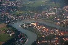
From here, it runs eastwards through a large valley via Bruck south of Lake Zell to Schwarzach im Pongau. It then turns northwards, passes Sankt Johann im Pongau, flows in-between the Berchtesgaden Alps and the Tennen Mountains to Hallein and the city of Salzburg.
From the junction with its Saalach tributary in the northern Salzburg basin, the Salzach forms the border between Bavaria, Germany and the Austrian states of Salzburg and Upper Austria for almost 70 kilometres (43 mi). Cities on the banks in this lower section include Laufen and its sister town Oberndorf bei Salzburg, Tittmoning, and Burghausen. All these towns have border crossings.
The river finally joins the Inn in Haiming between Burghausen and Braunau.
Tributaries
Upper and lower reaches: Putzengraben, Trattenbach and Dürnbach from the Kitzbühel Alps, Krimmler Ache, Obersulzbach, Untersulzbach, Habach, Hollersbach, Felberbach, Stubache, Kapruner Ache from the High Tauern, Pinzga from Lake Zell, Fuscher Ache, Rauriser Ache from the High Tauern, Dientener Bach from the Slate Alps, Gasteiner Ache, Großarlbach, Kleinarlbach from the High Tauern, Fritzbach from the Dachstein Massif, Mühlbach and Blühnbach from the Hochkönig.
Lower reaches: Lammer from the east, Torrener Bach (Bluntautal) from the Berchtesgaden Alps, Tauglbach and Almbach from the Hintersee, both from the Osterhorn Group, Königsseer Ache from the Königssee, Kehlbach, Fischach from the Wallersee, Klausbach, Saalach the largest tributaries, Sur and Götzinger Achen on the Bavarian side, Oichten near Oberndorf and Moosach in the Salzburg-Upper Austrian border region.
Hydroelectric power plants
Currently, there are 12 hydroelectric power plants on the Salzach. The power plants are listed beginning at the headwaters:
| Dam | Nameplate capacity (MW) | Annual generation (Mio. kwh) |
|---|---|---|
| Schwarzach[1] | 120 | 482 |
| Wallnerau[1] | 13 | 38 |
| St. Veit[1] | 16 | 67 |
| St. Johann[1] | 16 | 71 |
| Urreiting[1] | 16 | 76 |
| Bischofshofen[1] | 16 | 70 |
| Kreuzbergmaut | 18 | 80 |
| Werfen-Pfarrwerfen[1] | 16 | 81 |
| Gamp[2] | 8 | 53 |
| Sohlstufe Hallein[3] | 16 | 81 |
| Urstein[4] | 22 | 120 |
| Sohlstufe Lehen[5] | 13 | 81 |
Photos
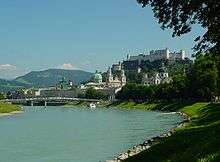
 Salzach in Salzburg
 Salzach in Salzburg
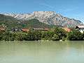 Salzach between Hallein and Salzburg
 Salzach between Tenneck and Pass Lueg
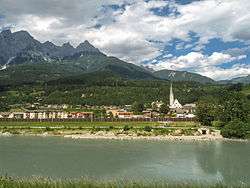 Salzach near Pfarrwerfen
 "Staatsbrücke" bridge over Salzach in Salzburg
See also
Sources
| Wikimedia Commons has media related to Salzach. |
- Österreichisches Bundesministerium für Land- und Forstwirtschaft, Umwelt und Wasserwirtschaft: Die Salzach - ein Fluss bewegt! (PDF, 7,94 MB)
- Norbert Winding und Dieter Vogel (Hrsg.): Die Salzach. Wildfluss in der Kulturlandschaft. Verlag Kiebitz Buch, Vilsbiburg 2003, ISBN 3-9807800-1-5
References
- 1 2 3 4 5 6 7 "Die Salzach" (in German). Verbund. Retrieved 2016-09-03.
- ↑ "Kraftwerk Gamp" (in German). Salzburg AG. Retrieved 2016-09-06.
- ↑ "Kraftwerk Sohlstufe Hallein" (in German). Salzburg AG. Retrieved 2016-09-06.
- ↑ "Kraftwerk Urstein" (in German). Salzburg AG. Retrieved 2016-09-06.
- ↑ "Kraftwerk Sohlstufe Lehen" (in German). Salzburg AG. Retrieved 2016-09-09.