Sam's Point Preserve
| Sam's Point Preserve | |
|---|---|
|
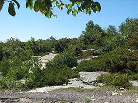
Pine barrens | |
 Map of New York | |
| Location | Ulster County, New York |
| Nearest city | Ellenville |
| Coordinates | 41°40′09″N 74°21′19″W / 41.66926°N 74.35521°WCoordinates: 41°40′09″N 74°21′19″W / 41.66926°N 74.35521°W |
| Area | 4,600 acres (19 km2) |
Sam's Point Preserve, or Sam's Point Dwarf Pine Ridge Preserve, is a 4,600-acre (19 km2) preserve in Ulster County on the highest point (2,289 feet [698 m]) of the Shawangunk Ridge in New York, on the Wawarsing, New York-Shawangunk town line. It is owned by the Open Space Institute and managed by the New York State Office of Parks, Recreation and Historic Preservation after having previously been managed by The Nature Conservancy. Its unique environment features dwarf pine trees along the ridgetop. Located within the park is Lake Maratanza, the highest lake on the ridge, and the Ellenville Fault Ice Caves.
History
The name derives from a story that a man named Sam, pursued by Indians, jumped off the cliff to avoid capture and miraculously survived the drop with the trees breaking his fall. Roads throughout the preserve were built as fire roads in the 1930s by the Civilian Conservation Corps.
The land was once owned by the nearby village of Ellenville to protect its watershed and partly by a company which offered tours of the ice caves. The Open Space Institute, working with The Nature Conservancy bought it with assistance from the Lila Acheson and Dewitt Wallace Fund for the Hudson Highlands, after the village considered selling the land to developers.
In 2005, the Preserve opened the Sam’s Point Conservation Center with education facilities, exhibits and a gift shop. A parking fee of $10 per vehicle is charged.
Management of the preserve was transferred to the New York State Office of Parks, Recreation and Historic Preservation and the Palisades Interstate Park Commission in April 2015, after having been managed by The Nature Conservancy since 1996. The preserve is currently managed as part of Minnewaska State Park Preserve.[1]
In April 2016, a fire of unknown origin burned 2,028 acres (821 ha) of the park and nearby woodlands. It has been closed to the public in the aftermath.[2]
Ellenville Fault Ice Caves
The Ellenville Fault Ice Caves is the largest known open fault in the United States with corresponding ice caves. As a result of the cool microclimate, ice is present throughout the year and more northern plants such as black spruce, hemlock, mountain ash, and creeping snowberry, and bryophytes such as Isopterygium distichaceum are able to survive.[3] It was designated a National Natural Landmark in November 1967.[4]
There are hiking trails to the ice caves which are open in the summer, but a permit is required to visit the area.
Trails
The Long Path long-distance hiking trail crosses it, eventually reaching VerKeerderkill Falls. A branch leads to Sam's Point (with a view of land for many miles, sometimes as far as High Point in New Jersey), and another to the ice caves, with solar powered lights. Visitors who want to get to Sam's Point have to go through Cragsmoor. Sam's Point Preserve is near the Mohonk Preserve and Minnewaska State Park Preserve.
Gallery
 Looking down the access road, just under the Point
 A portion of the CCC fire road
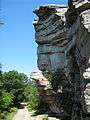
 Hiking to the Ice Caves
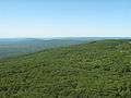 View from the Point, looking to the southeast
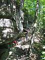 Along the trail to the Ice Caves
See also
References
- ↑ "Sam's Point Preserve". Nature.org. The Nature Conservancy. Retrieved February 6, 2016.
- ↑ Randall, Michael (April 29, 2016). "With Sam's Point wildfire contained, firefighters will focus on remaining hot spots". Times-Herald Record. Retrieved May 5, 2016.
- ↑ Significant Habitats and Habitat Complexes of the New York Bight Watershed: Shawangunk - Kittatinny Ridge
- ↑ "Ellenville Fault-Ice Caves". nps.gov. National Park Service.
External links
- Nature Conservancy page
- Open Space Institute page
- Point Preserve - Sam's Point Dwarf Pine Ridge Preserve Trail Details and Info
- Trail Map to Ice Caves
- Sam's Point Ice Caves Re-opened to the Public