San Miguel Arcángel Church (Cabo Rojo)
| Iglesia San Miguel Arcángel | |
|---|---|
 | |
| Basic information | |
| Location | Cabo Rojo, Puerto Rico |
| Affiliation | Roman Catholic |
| District | Roman Catholic Diocese of Mayagüez |
| Year consecrated | 1783 |
| Ecclesiastical or organizational status | Church |
| Website | |
| Architectural description | |
| Architect(s) | First Construction: Unknown |
| Architectural style | Neoclassical |
| Groundbreaking | 1773 |
| Completed | 1783 |
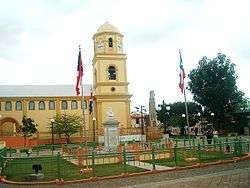
Iglesia San Miguel Arcángel is a Roman Catholic parish church located in Cabo Rojo, Puerto Rico. Construction on the building started in 1773 and was completed in 1783. The church's archives holds the birth records of Ramón Emeterio Betances, Salvador Brau, and the pirate Roberto Cofresi.[1]
History
A description of the church from 1843 indicates that it had three naves separated by arches of wood, covered with tiles, with a ceiling vault. In 1927, Father Joe Smith collected funds to build a dome over the altar and repair the sacristy. Father Benito Sanchez gave the task of commissioning a number of additional works, among them, raising the height of the nave an additional ten feet. In 1936, Father Benito died and is the only Augustine priest buried in the church.[2]
To free children from slavery, Ramón Emeterio Betances used to come to the door of the church on Sunday and, as the baby slaves were bought out from their christening ceremonies, he paid twenty five pesos (once baptized the cost for the slaves were doubled at 50 pesos).[3]
In 2004, the church was designated a historic monument by the Puerto Rican government.[2] The church is part of the Roman Catholic Diocese of Mayagüez.[4]
References
- ↑ "Municipio Autónomo de Cabo Rojo". Retrieved 2009-04-09.
- 1 2 "Ley Núm. 150 del año 2004" (in Spanish). Lex Lexis. Retrieved 2009-04-09.
- ↑ The way it was, and other writings. Arte Publico Press. 1993. p. 91. ISBN 1-55885-057-0. Retrieved 2009-04-09.
- ↑ "Diocesis Mayagüez". Retrieved 2009-04-09.
Coordinates: 18°5′12.36″N 67°8′45.61″W / 18.0867667°N 67.1460028°W