San Pedro de Inacaliri River
| San Pedro de Inacaliri River | |
|---|---|
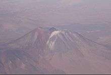 San Pedro volcano looking south to San Pedro River | |
| Country | Chile |
| Basin | |
| River mouth | Loa River |
| Basin size | 9,850 km2 (3,800 sq mi) |
| Physical characteristics | |
| Length | 76 km (47 mi) |
| Discharge |
|
San Pedro de Inacaliri River, or called simply San Pedro River, is a river of Chile located in El Loa Province, Antofagasta Region. It begins at the confluence of the rivers Silala and Cajón, at an elevation over 4,000 m asl.
A part of its flow is diverted (between 50 and 60 l/s) and conducted across the desert to Chuquicamata for domestic water supply. About 8 km south, the waters of the river disappear in a floodplain area to reappear 15 km downstream at the so-called Ojos del San Pedro in the form of a partially overground stream, at the eastern border of a salt flat with a surface of 5 km².
.svg.png)
Loa and its afluents San Pedro, Silala and Salado Rivers
Before discharging into Loa River, the river skirts the San Pedro volcano, where it has carved a 100-m-deep canyon through a rhyolite lava flow.
| Rivers | ||
|---|---|---|
| Lakes | ||
References
- This article draws heavily on the corresponding article in the Spanish-language Wikipedia, accessed August 31, 2007.
- Niemeyer, Hans; Cereceda, Pilar (1983). Geografía de Chile — Tomo VIII: Hidrografía (1º edición, Santiago de Chile: Instituto Geográfico Militar ed.).
This article is issued from Wikipedia - version of the 6/10/2016. The text is available under the Creative Commons Attribution/Share Alike but additional terms may apply for the media files.