San Pitch River
| San Pitch River (Sahpeech (Ute)) | |
| "SanPitch" | |
| river | |
| Country | United States |
|---|---|
| State | Utah |
| Part of | Escalante-Sevier subregion |
| Length | 65 mi (105 km) [1] |
| Basin | 480 sq mi (1,243 km2) [2] |
 The San Pitch is to the east of the Great Basin section but within the Great Basin (west of the Great Basin Divide). | |
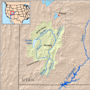
The San Pitch River, extending 65 miles (105 km), is the primary water course of the Sanpete Valley and drains into the Sevier River in southwestern Sanpete. The river is named for the Ute chief Sanpitch, who also gives his name to the San Pitch Mountains and Sanpete County.
Course
The upper San Pitch River begins north of Milburn, Utah near Oak Creek Ridge[3] on the Northern Wasatch Plateau and flows south to Moroni. The middle San Pitch River runs from Moroni where it crosses State highway 132. The middle San Pitch River runs from U132 to Gunnison Reservoir. The lower San Pitch River flows from Gunnison Reservoir to where it meets the Sevier River, west of Gunnison, Utah.
See also
References
- ↑ "The National Map". U.S. Geological Survey. Retrieved Feb 16, 2011.
- ↑ "Boundary Descriptions and Names of Regions, Subregions, Accounting Units and Cataloging Units". USGS.gov. Retrieved 2010-06-06.
- ↑ Millennium Science and Engineering; James A. Harris; Harry Lewis Judd (2003). San Pitch River Watershed San Pitch River Watershed Water Quality Management Plan (PDF). Utah Department of Environmental Quality/Division of Water Quality. Retrieved 8 June 2013.
Coordinates: 39°8′8.8596″N 111°52′31.7352″W / 39.135794333°N 111.875482000°W