Sand to Snow National Monument
| Sand to Snow National Monument | |
|---|---|
|
IUCN category V (protected landscape/seascape) | |
 | |
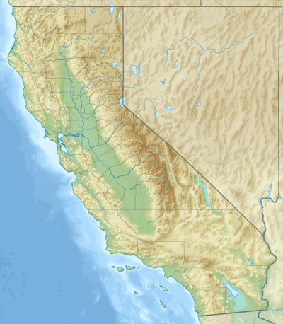  | |
| Location | San Bernardino County, California, USA |
| Coordinates | 34°05′N 116°41′W / 34.08°N 116.68°WCoordinates: 34°05′N 116°41′W / 34.08°N 116.68°W |
| Area | 154,000 acres (62,000 ha) |
| Authorized | February 12, 2016 |
| Governing body | Bureau of Land Management, National Forest Service |
| Website | Sand to Snow National Monument |
Sand to Snow National Monument is a U.S. National Monument located in San Bernardino County and into northern Riverside County, Southern California.
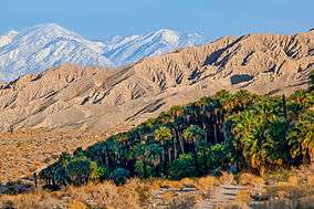
It protects diverse montane and desert habitats of the San Bernardino Mountains, southern Mojave Desert, and northwestern Colorado Desert.[1]
Geography
The national monument protects a total of 154,000 acres (62,000 ha), with the Bureau of Land Management (BLM) managing 83,000 acres (34,000 ha) acres, and the USFS−San Bernardino National Forest managing 71,000 acres (29,000 ha).[2][3][4] It extends from around 1,000 feet (300 m) on the Coachella Valley desert floor up to over 11,000 feet (3,400 m) in the San Bernardino Mountains.
Over 100,000 acres (40,000 ha) of the national monument are within the San Gorgonio Wilderness area, which was designated by Congress in 1964.[2][3] An eastern border in the Little San Bernardino Mountains abuts Joshua Tree National Park. A separate section expands the Bighorn Mountain Wilderness area to the northeast.
30 miles (48 km) of the Pacific Crest National Scenic Trail pass through the monument.[3] The headwaters of the Santa Ana River, Whitewater River, Morongo Creek, and San Gorgonio River are within it. The park protects a significant wildlife corridor and landscape linkage between the San Bernardino National Forest/San Gorgonio Wilderness area, Joshua Tree National Park, and Bighorn Mountain Wilderness area.[5]
Ecology
Diverse plant communities in the park support flora of the higher Mojave and lower Sonoran Colorado Deserts, chaparral, California oak woodland, coniferous forest, and alpine ecosystems, making it the most botanically rich national monument in the United States.[5]
Plant life native to the San Bernardino Mountains is influenced by their location at the convergence of three distinct ecosystems: California chaparral and woodlands to the west, Mojave Desert to the east, and Sonoran Desert to the south. There are over 1,600 different plant species native to the range.[5][6]
Sand dunes are home to the endangered fringe-toed lizard at the lower elevation confluence of the Whitewater and San Gorgonio Rivers, while Desert bighorn sheep are found at higher elevations.[5]
Designation
Sand to Snow National Monument was designated by President Obama on February 12, 2016 along with Castle Mountains National Monument and Mojave Trails National Monument.[2][7][8] It is governed by the United States Forest Service and the Bureau of Land Management.
The Sand to Snow National Monument was inspired by The Wildlands Conservancy’s twenty-year-old Sand to Snow Wilderness Interface Project that included more than 60,000 acres (24,000 ha) of privately-funded land acquisition, including private properties threatened with development.[5] The Conservancy established Whitewater Preserve,[9] Mission Creek Preserve,[10] and Pioneertown Mountains Preserve.[11]
See also
- Natural history of the Mojave Desert
- Natural history of the Colorado Desert
- San Bernardino Mountains topics
References
- ↑ BLM California: Map of Sand to Snow National Monument, with both BLM & USFS sections.
- 1 2 3 Whitehouse.gov: Presidential Proclamation − Establishment of the Sand to Snow National Monument, 12 February 2016 — "The USFS shall manage that portion of the monument within the boundaries of the San Bernardino National Forest, and BLM shall manage the remainder of the monument."
- 1 2 3 "BLM California: Sand to Snow National Monument". 1 March 2016. Retrieved 7 April 2016.
- ↑ USDA Forest Service: Sand to Snow National Monument webpage.
- 1 2 3 4 5 The Wildlands Conservancy: Sand to Snow National Monument
- ↑ The Wildlands Conservancy: Whitewater Preserve Plant List, flora of Whitewater River Canyon, San Bernardino Mountains.
- ↑ Sahagun, Louis (February 11, 2016). "Obama creates 3 new national monuments to protect 1.8 million acres of California desert". Los Angeles Times. Retrieved 2016-02-12.
- ↑ Eilperin, Juliet. "With 3 new monuments, Obama creates world's second-largest desert preserve". The Washington Post (February 12, 2016). Nash Holdings LLC. Retrieved February 12, 2016.
- ↑ Wildlands Conservancy.org: Whitewater Preserve
- ↑ Wildlands Conservancy.org: Mission Creek Preserve
- ↑ Wildlands Conservancy.org: Pioneertown Mountains Preserve
External links
| Wikimedia Commons has media related to Sand to Snow National Monument. |
- USFS: Sand to Snow National Monument website
- BLM California: Sand to Snow National Monument website
- Sand to Snow National Monument Map
- Sand to Snow National Monument Q&As
- Presidential Proclamation -- Establishment of the Sand to Snow National Monument